ATSC 113 Weather for Sailing, Flying & Snow Sports
Clouds > Convective Clouds
Learning Goal 1a. Identify & classify clouds, and relate them to local and larger-scale weather systems.
Convective clouds or cumuliform clouds (Cu) look like stacks of cotton balls. They form when warm humid air rises through cooler surrounding air in the atmosphere. The buoyancy (tendency of objects to sink or rise due to density differences with their surroundings) associated with the warm air drives strong updrafts. Even more buoyancy is created as water vapor in the air condenses to become cloud droplets, because condensation releases latent heat (energy required during a phase change — in this case, condensation).
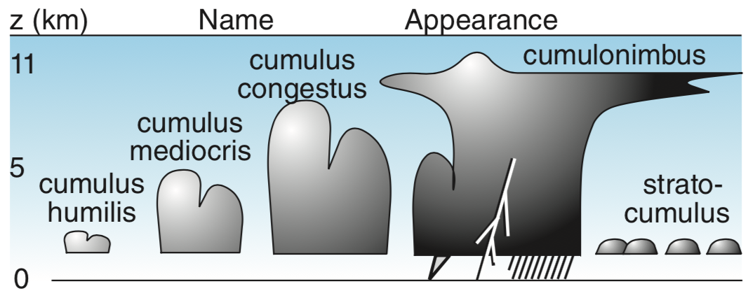
Convective clouds often have relatively flat bases that are somewhat near to the ground (roughly 1km above the ground, though this varies significantly from cloud to cloud). However, the vertical depth of the clouds can vary significantly. These clouds come in 4 sizes:
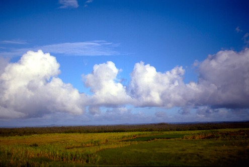
- Small: cumulus humilis (Cu hum), also called "fair weather cumulus"
- Medium: cumulus mediocris (Cu med)
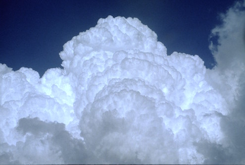
- Large: cumulus congestus (Cu cong), also known as towering cumulus (TCu)
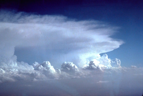
- Extra large: cumulonimbus
(Cb), also called thunderstorms (see learning goal 4)
The sketch below shows how cumuliform clouds are classified by their vertical depths (where z = height above ground):
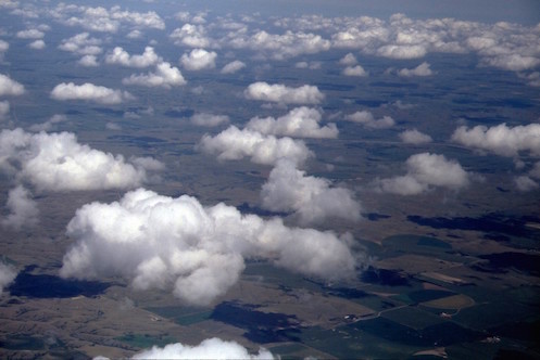
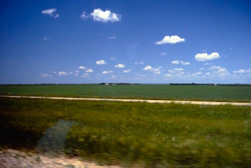
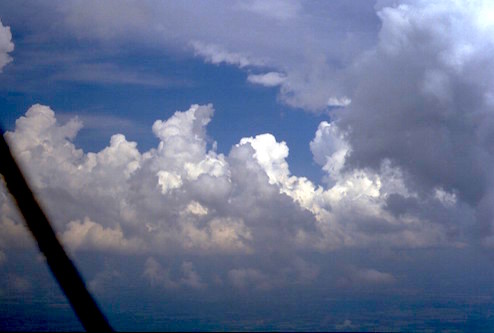
Here are some photos showing how these different sizes of cumuliform
clouds look, both from aircraft and from the ground. In the first
column are also links to timelapse videos from the weather cameras on
the rooftop of our institute at UBC.
Convective Clouds |
Viewed from Aircraft |
Viewed from Earth's Surface |
| 1. Small. Cumulus humilis (rooftop video) |
 |
 |
| 2. Medium. Cumulus mediocris (rooftop video) |
 |
 |
| 3. Large. Cumulus congestus (rooftop video. The Cu-con are over the mountains in the background.) |
 |
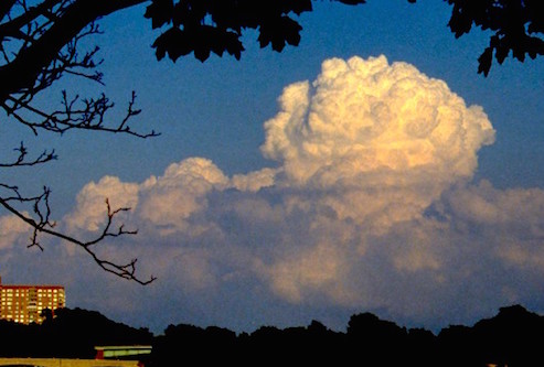 |
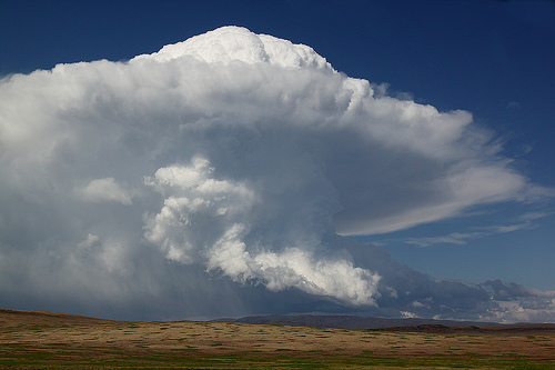
| 4. Extra Large. Cumulonimbus = Thunderstorm (rooftop video showing life-cycle of storms triggered over the mountains) |
 |
 |
Where do they form?
Convective clouds form wherever the air near the ground is colder than the ground- or ocean-surface. This can happen:
- behind cold fronts (where a warm air mass is forced upwards by collision with a cold air mass),
- on mostly clear days when sunshine warms the ground more than the overlying air,
- over urban and industrial centers that are warmer than the surrounding rural areas,
- or when cold air blows over a warmer ocean or lake, or over warmer land.
Also, mountains can trigger all sizes of cumulus clouds, including thunderstorms. Mountain clouds are explained in Learning Goal 1b "Recognizing Special Clouds".
Local Effects
For all size cumulus clouds, there is usually an updraft that starts near ground level and extends up into the cloud all the way to the cloud top. Birds and sailplane (glider designed for sustained flight) pilots intentionally circle in the updrafts to get a free lift to higher altitude. Between the updrafts are weaker downdrafts of clear air. Airplane and helicopter pilots flying at a constant altitude below cloud base would feel a bumpy ride as they fly through the up- and down-drafts.
At the earth's surface, the downdrafts of air hitting the ground cause windgusts that sailors can see as slightly rougher, darker-looking patches of water called "cat's paws". Similar gusts over pastures and grain crops can cause wavy fields of grain.
Hazards
Deeper cumuliform clouds have stronger updrafts. The deepest ones, cumulus congestus and thunderstorms, have such violent updrafts that they can be a hazard to aircraft. Namely, the strong updrafts can cause the pilot to lose control of the aircraft, or can over-stress the aircraft, causing things to break. The medium and smaller cumulus can be flown under and through, but will cause a bumpy ride — so be sure to have your seat belt fastened (and shoulder harness, if available), and provide barf bags to your passengers.
Key words: buoyancy, cat's paws, cold front, convective cloud, cumuliform cloud, cumulonimbus, cumulus congestus, cumulus humilis, cumulus mediocris, latent heat, thunderstorm
Extra info for experts; Not Needed for this Course.
Use this expert_resources link to find all the items listed below:
- Item - Topic
- World.A.1. - World Meteorological Organization (WMO) "International Cloud Atlas"
- USA.B.1. - Wikipedia list of cloud types
- World.A.2. - WMO: Manual on Cloud Observations (an old, outdated document)
- USA.A.1. - American Meteorological Society (AMS): Glossary of Meteorology
- USA.C.1. - Practical Meteorology (PrMet): Chapter 6, Clouds
Image credits. All figures by Roland Stull, except
the bottom right photo (thunderstorm viewed from the ground) © 2010
Wolf Read, used
with permission. All rooftop videos by the University of British Columbia.