ATSC 113 Weather for Sailing, Flying & Snow Sports
Visibility
Learning Goal 1e. Contrast horizontal visibility, vertical visibility, and runway visual range (RVR), and discuss how they affect aviation.
Aviation defines horizontal visibilities, vertical visibilities, and slant visibilities.
Suppose there is a thin layer of fog at an airport. A pilot flying over the airport looking straight down (vertical visibility) or at a nearly vertical angle (slant visibility) might be able to see the runway, hangars, and other aircraft because only a relatively short vertical distance along the line of sight is filled with fog droplets. So the pilot might (mistakenly) think that it is safe to land. But as the aircraft gets lower during its descent toward landing, the aircraft will enter the fog. The pilot needs to look straight ahead (horizontal visibility) to find the runway. But now, with both the aircraft and the destination in the fog, the sight line is along a much longer path through the fog, making it harder to see.
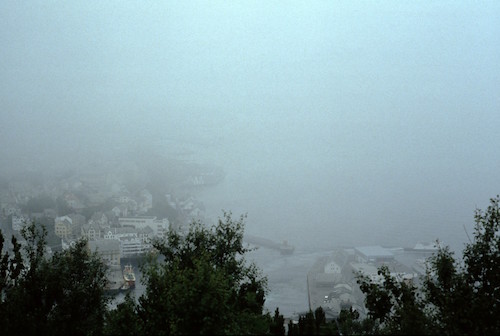
Slant visibility look down toward the town of Ålesund, Norway, from a tall hill. Imagine trying to find an airport and land in these conditions.
For this reason, horizontal visibilities are the ones measured and reported at airports, because it is the one most relevant for safety. If you hear the word "visibility" without any adjectives in front, then assume it is a horizontal visibility.
Horizontal Visibility
Visibility is a measure of how far away you can see a black object during daytime, or how far away you can see a bright light at night. It is measured as a distance, e.g. the visibility is 8 km. For Canadian aviation, visibility is reported in statute miles over land, and nautical miles over the ocean. US aviation uses statute miles. The World Meteorological Organization (WMO) recommends kilometres or metres.
If the visibility is poor (such as in hazy, foggy, cloudy, snowy, volcanic ashy, dusty, sandy, or smoky/polluted air, see Learning Goal 1i), then pilots will have difficulty seeing:
- the ground, for landmarks for navigation
- other aircraft or obstacles (such as tall towers), so they don't hit them
- the horizon, to help them keep the plane flying level
- the runway at an airport, for landing
The time between when the pilot first sees an obstacle and when the aircraft hits it depends on the visibility. Commercial airliners fly at roughly 300 knots (555 km/h) . If you are flying in a much slower general-aviation (small) aircraft at 200 km/h, and if the visibility is 2 km, then the time between when you first see an obstacle and when you hit it is (2 km) / (200 km/h) = 0.01 hours = 36 seconds. OK, that should be enough time for you to recognize the hazard, consider your options, and move the aircraft controls to change its direction or altitude, and for the aircraft to respond to your control inputs.
But suppose the visiblity is 0.5 km. Then you have only 9 seconds to react (or even less time if you are in a faster aircraft) — not a lot of time. Plus, consider this: pilots need to divide their attention between looking out the window straight ahead, checking different directions out the window, navigating (checking their charts and navigation instruments onboard), checking the aircraft engine instruments and fuel tanks, tuning their communications radio to different frequencies, etc. So the pilot might not be looking out the window when the obstacle first appears.
For this reason, visibility rules exist for flight safety. If visibility is good and exceeds a certain threshold (a condition called visual meteorological conditions, VMC), then the pilot is allowed to fly under the Visual Flight Rules (VFR). However, when visibility is poor (instrument meteorological conditions, IMC), only specially-trained pilots flying aircraft with special instruments can fly, on instrument flight rules (IFR), and following specific directions given by air traffic control (people on the ground with radar and other tracking methods such as GPS to make sure you don't hit other aircraft, and can get where you want to go without hitting any obstacles). See more info about VFR and IFR in Learning Goal 1g.
Measuring Visibility
Human observers often estimate visibility by trying to see landmarks of known distances from the airport, such as tall towers, mountains, trees, or smoke stacks. As viewed at eye level by an observer on the ground, such as in the photo below.

Some automated instruments (called transmissometers) shine an incident light beam across a known path length (e.g. 250 feet), and measure how much dimmer the received (transmitted*) light is compared to when the air is clean.
Other instruments measure how much light is scattered (bounced off in all directions) from tiny particles (of dust, fog, smoke, etc.) in the air.
Of these instruments, some detect forward-scattered light, which is scattered light leaving the tiny particles in roughly the same direction as the incoming (transmitted*) laser beam. Other instruments measure how much is back-scattered, roughly opposite to the incoming beam. Yet others measure how much is side-scattered, as sketched below.
| Back-scatter visibility meter | 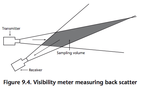 |
| Forward-scatter visibility meter | 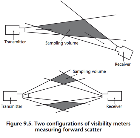 |
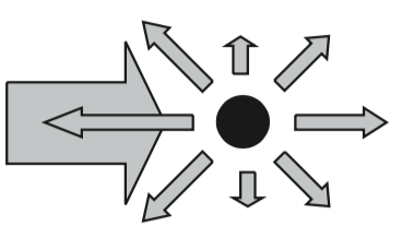
| Side-scatter (wide range of angles) visibility meter | 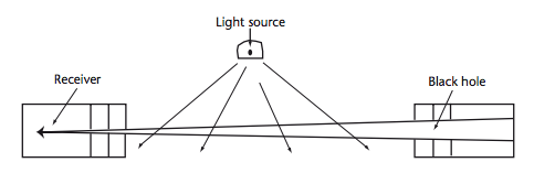 |
Diagrams courtesy of the World Meteorological Organization (WMO) Guide to Meteorological Instruments and Methods of Observation, WMO-No. 8 (2008 edition, updated in 2010), Part I, Chapter 9: Measurement of Visibility.
* The word "transmitted" is used in opposite ways in some of the figures above. For the transmissometer, the transmitted light is the dimmed light that is received at the detector. For the scattering visibility meters, "transmitted" is the incident laser light that is emitted from the laser, i.e. the transmitter refers to the light source.
Runway Visual Range (RVR)
For busy airports, sometimes these automated visibility sensors are installed close to a runway to measure runway visual range (RVR). This indicates how far (in meters or feet) ahead a pilot can see horizontally along a runway centerline. RVR is usually reported only when visibilities are poor (i.e. less than about 2,000 m or less than 6,000 feet). RVR 2600 feet ≈ 0.5 statuate mile. RVR 1200 feet ≈ 0.25 statuate mile.
Vertical Visibility (VV)
In the diagram below, the top frame shows clouds (grey) and non-cloudy air (blue). The height of the cloud base above ground defines the ceiling altitude. In the bottom frame is an obscuration (e.g. dust, smoke, fog, mist, etc., sketched as bluish grey) that reduces visibility in all directions. In obscuration conditions (i.e. an indefinite ceiling), the limit that you can see vertically is the vertical visibility (VV), and is used instead of the normal ceiling height.
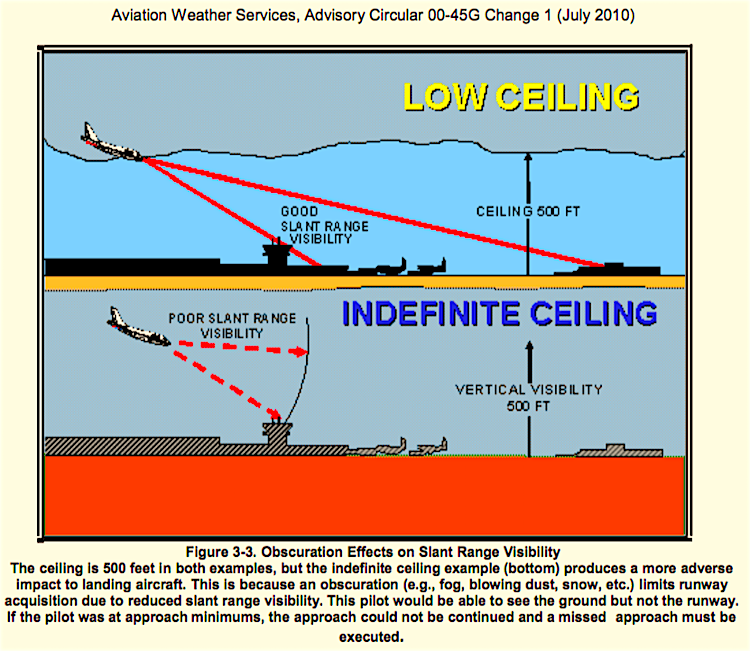
Vertical visibility is determined by either:
- The distance that an observer can see vertically into an indefinite ceiling;
- The height corresponding to the top of a ceiling light projector beam;
- The height at which a ceiling balloon (a bright red balloon filled with helium) completely disappears during the presence of an indefinite ceiling; or
- The height determined by the sensor algorithm at automated stations (based on horizontal visibility).
CAUTION: It is ambiguous (and wrong) to use the phrase "the atmosphere is clear" when discussing visibility. Instead, for visibilities, use "visibility is unlimited" or "visibility is OK", both of which mean the visibility is 10 km (6 statute miles) or greater. The phrase "clear skies" means no clouds.
Keywords: air traffic control, back scatter,
forward scatter, horizontal visibility, runway visual range (RVR),
scatter, side scatter, slant visibility, transmissometer, vertical
visibility (VV), visibility, World Meteorological Organization (WMO),
instrument flight rules (IFR), visual flight rules (VFR), ceiling
Extra info for Experts; Not Needed for this Course.
- Environment Canada: Manual of Observations (MANOBS)
- Canadian TC Low Visibility Operations FAQs. AC 602-002.
- ICAO report on visibility vs RVR
- ICAO Annex 3: Meteorological Service for International Air Navigation. See Chapter 1: Definitions.
- World Meteorological Organization (WMO) Manual of Observations, Chapter 9 Visibility.
- US Federal Meteorological Handbook No. 1
- Chapter 6 (for horizontal visibility)
- Chapter 7 Runway Visual Range
- Chapter 9 (for vertical visibility)
- USA FAA AIM, section 7-1-15 on RVR and section 7-1-17 on Prevailing Visibility.
- Comparison of different visibility sensors: Chan, P.W., 2016: A test of visibility sensors at Hong Kong International Airport. Weather, October 2016, vol. 71, No. 10, p241-246. doi:10.1002/wea.2772 .
Image credits. All figures by Roland Stull, except where otherwise noted.