ATSC 113 Weather for Sailing, Flying & Snow Sports
Fog
Learning Goal 1h. Anticipate when fog might occur based on location, humidity, temperature, winds, and cloudcover, and how fog affects aviation.
Fog reduces visiblity and makes it difficult to see where you are, where the airport is, and where other airplanes are. This video show how fog at an airport can cause confusion and danger.
You can improve your safety by understanding what fog is, and how it forms.
Fog Formation and Dissipation
Fog is a cloud that touches the ground. Most fog is made of tiny liquid water droplets that are falling
so slowly through the air that they seem suspended. In fog, the visibility is very poor, usually less than about 1 km (or 5/8
mile). [Compare this to "mist", which is a diffuse fog with visibilities greater than about 1 km.]
If the fog is made of supercooled tiny liquid water droplets (unfrozen liquid water at temperatures below freezing), then it is called freezing fog, because the supercooled droplets can freeze instantly when they touch something like an airplane or runway. Ice fog is made of tiny ice crystals (water that is already frozen).
Fog can form due to two mechanisms:
- When water is added to unsaturated (non-foggy) air, or
- When unsaturated air is cooled to its dew-point temperature (the temperature at which water vapor starts to condense into liquid droplets).
Sometimes both mechanisms work together to make or maintain fog. Cooling is common at night, which is why fog is most likely during late night and early morning.
If the air is not very humid, then fog is less likely, because (1) there might not be enough water available to add to the air to make it saturated (foggy), or (2) the air might not get cold enough to reach its dew-point temperature. Conversely, fog is more likely in humid air, and most likely in cool humid air.
Cool air is denser (heavier) than warm air, so the cool air often flows downhill and settles into valleys. For this reason, many fogs form in low spots or valleys as valley fog. Unfortunately, airports are often in valleys.
On windy nights, the wind makes turbulence that mixes cool humid air near the ground with warmer drier air aloft. The resulting mixture is often too warm and dry to become fog. So, fog usually forms when the winds are relatively slow or near calm. Conversely, if fog already formed at night when winds were light, then the fog will dissipate if the wind speed increases.
On nights with clear skies, the ground surface radiates heat upward to space. As the ground loses heat, it gets colder, and the cold ground cools the air above it by contact. If the air is cooled sufficiently, and has sufficiently high humidity, then fog can form. If there is a deep layer of humid air near the ground, then the ground surface does not cool as much, but the deep layer of humid air cools directly by radiating heat to space. If this humid layer cools enough, then a deep fog layer can form that is difficult to dissipate.
On nights with substantial cloud cover, the clouds prevent the ground from cooling rapidly, because the clouds are radiating heat back to the ground.This blanketing effect by the clouds often prevents the ground (and the air touching the ground) from cooling sufficiently to make fog.
Fog formation and dissipation times are very difficult to forecast.
Types of Fog
Fog Type |
Mechanism |
Photo |
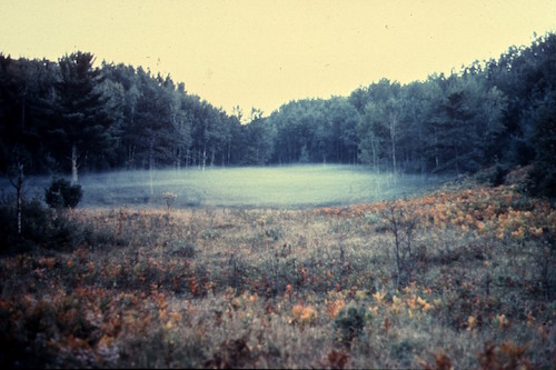
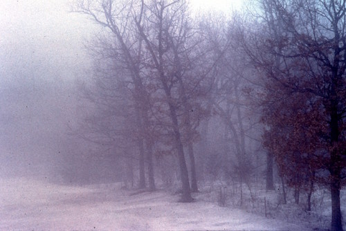
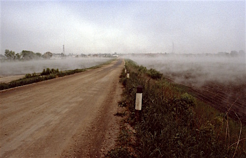
| Radiation | During clear, nearly-calm nights the ground cools by infra-red radiation to space. The cold ground cools the air that touches the ground. These fogs often form first as a very shallow fog, and gradually get thicker (deeper, and lower visibility) as the night progresses. If the fog gets deep enough, then IR cooling happens from fog top instead of from the ground, which quickly creates a deep fog layer that is difficult to dissipate. | 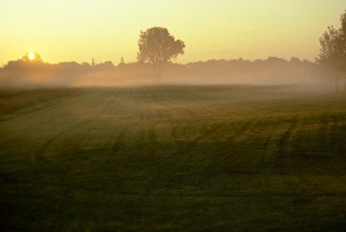 |
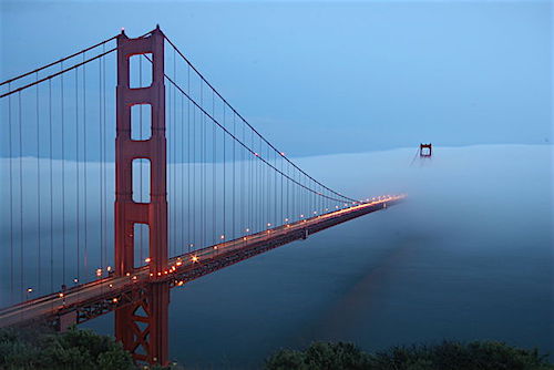
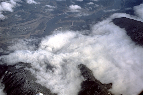
| Advection |
Humid air blows over a colder surface, causing the air temperature to decrease to the dew-point temperature.
These fogs can form as thick layers, sometimes with sharp, well-defined front edges. Second to last photo of the San Francisco Bay is courtesy of the NASA Earth Observatory. Last photo of fog at the Golden Gate Bridge © User: runner310 / Wikimedia Commons / CC BY 2.0. |
|
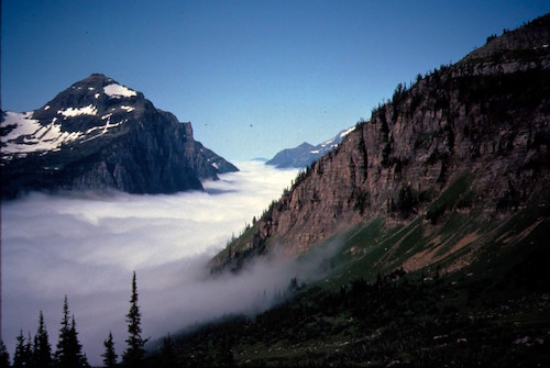
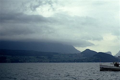
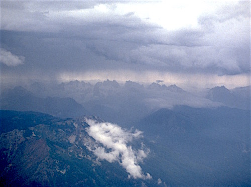
| Upslope |
When the wind blows air against a hill slope, the air is pushed upward. But upward-moving air cools adiabatically (without the transfer of heat) about 10°C for each 1 kilometer that it goes up. When the air rises sufficiently high and gets sufficiently cold, then fog can form. As the top photo shows, these fogs often appear as if the mountain top is in a cloud. If you were on the mountain top, you would be in fog. If you were at sea level in this photo, you would see the same phenomenon as a cloud that the mountain sticks up into. In the second photo example here, winds from the top left of the photo are blowing humid air toward mountains in the bottom right of the photo. As this air is funneled into the valleys and up the mountain slopes, upslope fog has formed. |
 |
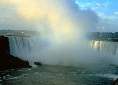
| Precipitation or frontal | Precipitation fog or frontal fog is formed by adding moisture, via the evaporation from warm rain drops falling down through the initially-unsaturated cooler air below cloud
base. This same situation creates fractus clouds, which could be reported as fog where the fractus clouds touch the ground or the mountain. It also forms from evaporation of other water drops, such as at waterfalls that produce large amounts of spray. |
 |
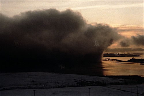
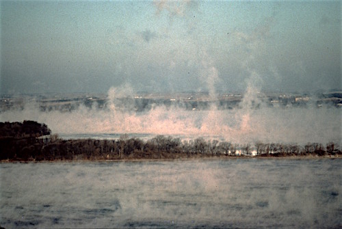
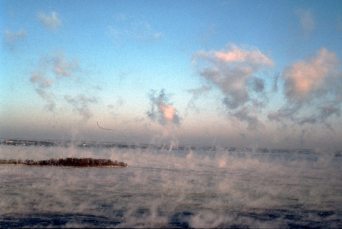
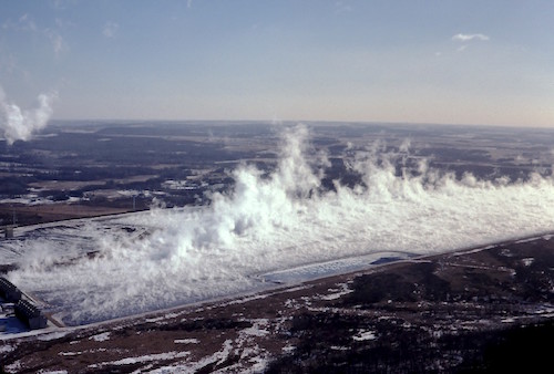
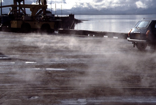
| Steam | Steam fog occurs when cold air moves over warm humid surfaces such as unfrozen lakes or oceans during early winter. The lake warms the air touching it by conduction, and adds water by evaporation. However, this
thin layer of moist warm air near the surface is unsaturated (not foggy). But the warm humid air is more buoyant than the rest of the cold air that is flowing over the lake. The warm air rises, creating a shallow (5 to 100
m) layer of convective turbulence touching the ground. As turbulence causes the humid air to mix with the colder air higher above the surface, the mixture becomes saturated, which we see as steam fog. One of the photos here shows steam fog over the warm water of a cooling pond next to a power plant. You can also see steam fog after a rain storm when the sun comes out and heats the wet surfaces, such as roofs, docks, and farm fields. |
|
Mechanism text is copied from Stull 2015: Practical Meteorology. Used with permission.
Some nice time-lapse photos of fog on YouTube:
- Vancouver, BC: https://www.youtube.com/watch?v=RHJXIXHhzKQ
- Golden Gate Bridge, California: https://www.youtube.com/watch?v=PFZFfaSKt5U
Landing a plane in dense fog using autopilot on YouTube:
- Landing a plane in zero visibility due to fog: https://www.youtube.com/watch?v=r-PB9JlyS_Q
Check your Understanding
- Which fog types are mostly caused by decreasing the air temperature?
- Which are caused mostly by adding water to the air?
- Which are caused by both mechanisms?
What you can do about fog
Unfortunately, fog and aviation do not play well together. Fog is considered to be an "obscuration" that reduces horizontal visibility to 0.5 statute miles or less. Fog prevents pilots from seeing where they are going (i.e. very reduced visibilty), and prevents weather observers from seeing the sky condition and weather above the fog.
There have been many occasions when I landed at an airport in nice weather one afternoon, and then woke up the next morning to find the airport "socked in" with fog. Even my instrument rating doesn't help, because pilots need a certain visibility to be able to see the runway to take off safely. Not much you can do, other than relax, read a good book, play with your smartphone, and wait for the fog to disappear before you take off...
When pilots do finally take off, if there is still a bit of reduced visibility due to a weak or thin fog, then pilots flying aircraft with carburated engines (engines that blend air and fuel) need to ensure that their carburator heat is turned on, to prevent ice from clogging up the air-fuel intake to the engine.
If you are already flying and find that your destination airport has become foggy before you arrived, then often your only choice is to fly to an alternate airport with nicer weather and spend one or more nights there. So be sure to have sufficient fuel on board if you intend to fly to a destination that is known to have a fog problem.
Fog can eventually dissipate (disappear / evaporate) or lift (change from fog into a low cloud). This improvement to the flying conditions can happen as the sunlight starts to warm the earth's surface, or as winds pick up and blow the fog away or turbulently dilute it with drier air. The thicker the fog, the longer it takes to dissipate. If conditions are really bad, the fog can persist all day.
Sometimes, the heat of a large nearby city, or the heat and turbulence from many commercial aircraft take-offs and landings at an airport, can delay the onset of fog, and can help dissipate it faster if it already exists. However, seeding the fog to make it disappear works rarely, and is very expensive. So we are just stuck with fog.
Fog depends so strongly on local conditions that many of the national weather prediction models do not forecast it very well. However, local forecasters with knowledge and experience with their local fogs can do a reasonable job estimating when fog will disappear. Fog forecasting is extremely difficult, and I commend the forecasters.
New Satellite-observed Fog products
The new GOES-18 (also known as GOES-West) geostationary weather satellite was launched on 1 March 2022 and became operational in 2023. GOES-18 replaced the earlier weather satellite GOES-17. GOES-18 provides a good view of the western half of the Americas. A corresponding GOES-East provides a similar view of the eastern half of the Americas.
These satellites have high spatial resolution (can see fine details), and observe many radiation bands (visible and infrared/heat). By combining several of these different bands, they can detect fog and low clouds at night, which is an amazing new capability.
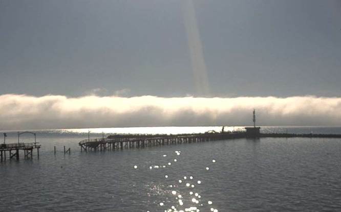
In the first photo below, at nighttime, the fog/low-clouds are coloured light blue. The corresponding photo taken later that same day during daytime (noon) is shown in the second figure, where all clouds, fog, and snow-capped mountains appear white. The third photo below shows corresponding ground-level view of the fog over the Georgia Strait, as viewed from the town of White Rock at 10:30 am that same day.
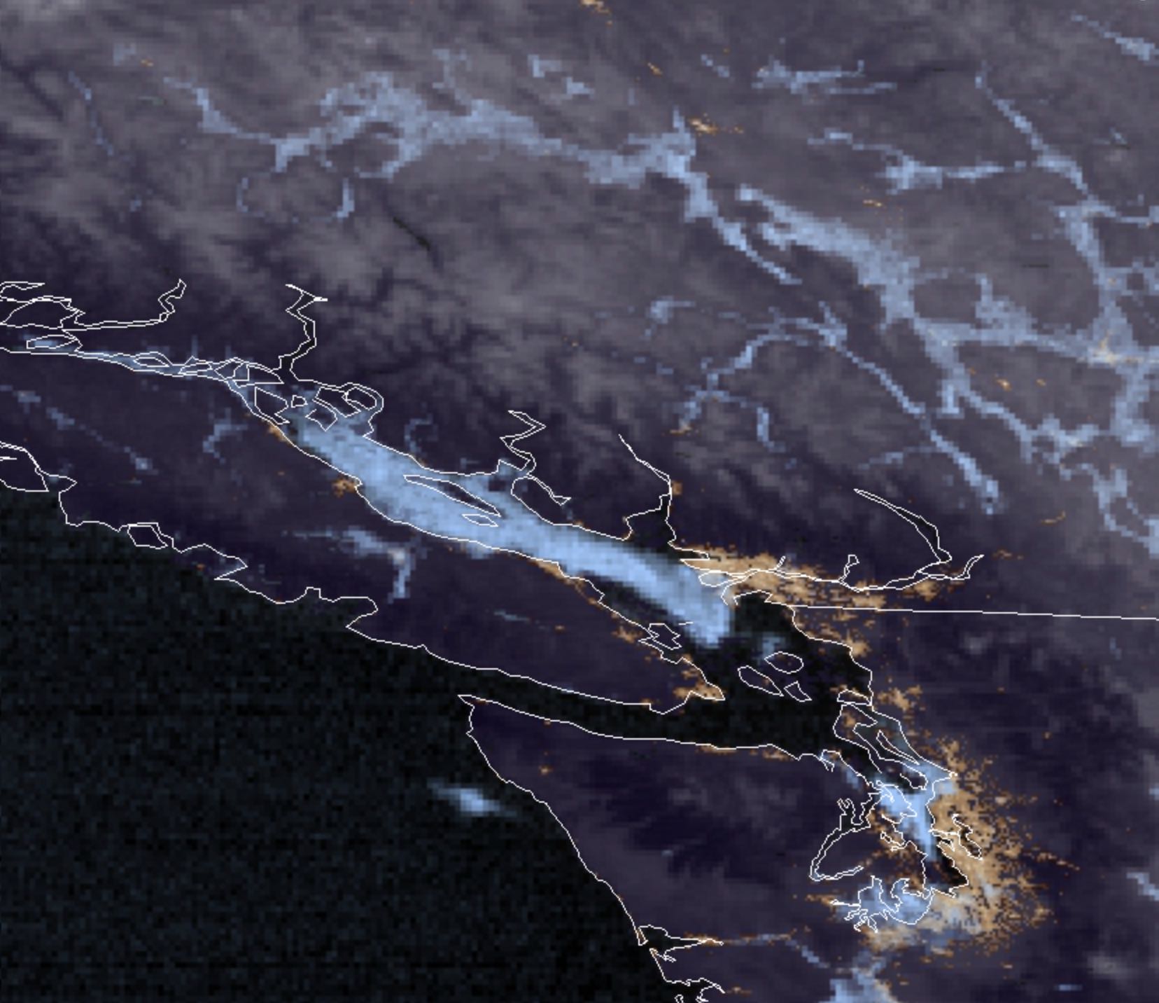
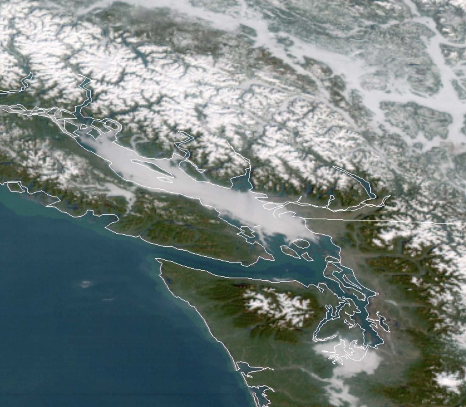
GOES 17 satellite images at night (top), and noon that same day (middle), on 14 January 2019. Fog appears light blue in the top (nighttime) images, and white in the middle (daytime) image.
Notice the fog in the mountain valleys in the upper-right portion of these top 2 images, and in the Georgia Strait (between Vancouver Island and the mainland). Also notice the snow-capped mountains in the middle
image. The bottom image shows the same fog as viewed from ground level at 10:30 am that same day, looking roughly south over the Georgia Strait from the town of White Rock. Top 2 images courtesy of NOAA/RAMMB.
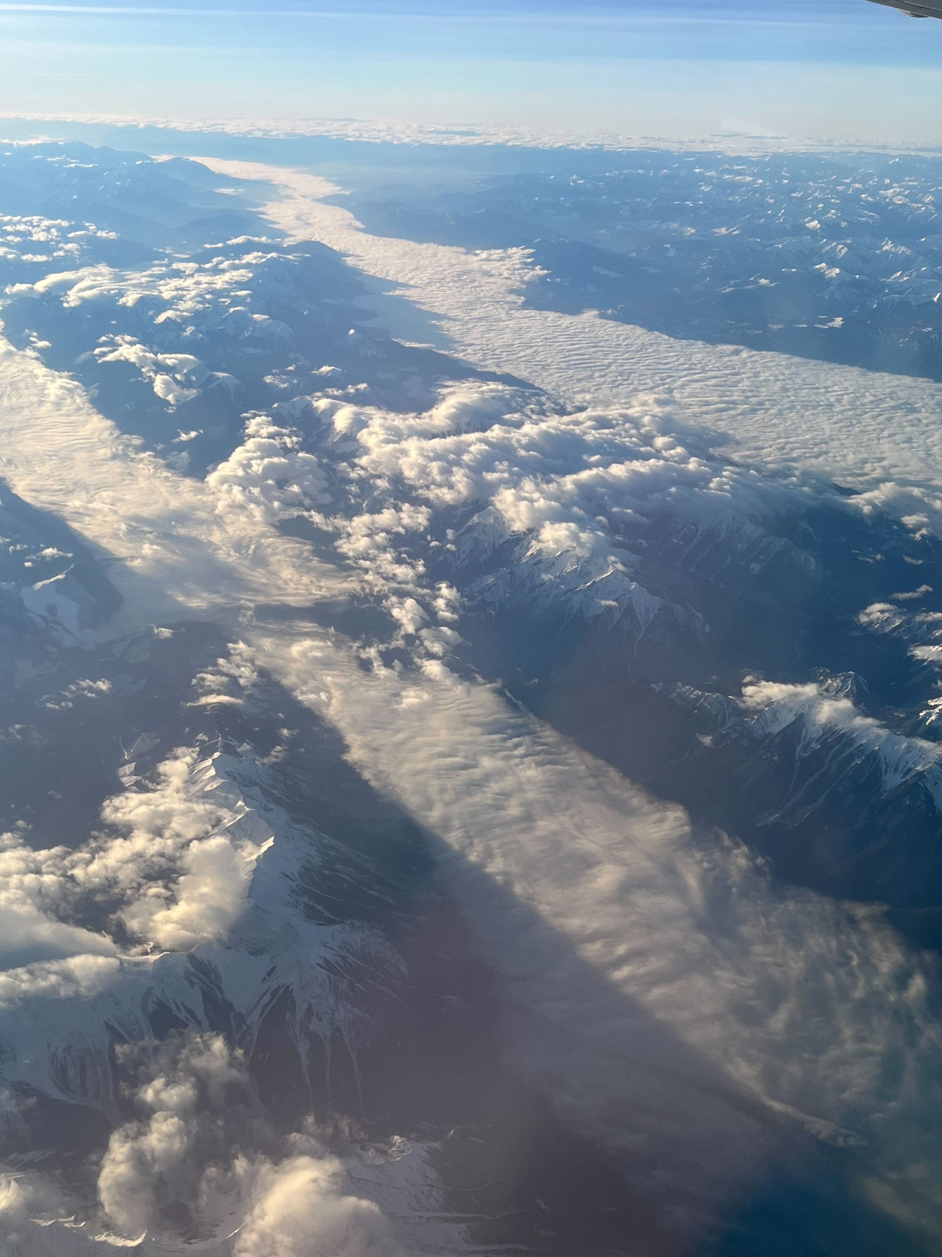
Photo taken from a commercial aircraft of valley low cloud or fog in the mountains of southeastern British Columbia. Photo by Lynn Engel, used with permission.
This fog-observation capability can be very important for aviation, especially for fog in remote locations for which there might not be weather stations or weather observers along your flight track.
For winter flights in Canada, when days are short and nights are long, information on fog along your route or at your destination can help you make better go/no-go decisions.
You can see a current loop of images from this satellite, zoomed
into British Columbia, at the rammb-slider/CIRA website
(it might take a long time to load these large images). This loop uses the infrared band at night and uses visible-light images during daytime, to make a movie that spans both day and night.
Key words: advection fog, dew-point temperature, dissipate, fog, freezing fog, ice fog, lift, obscuration, precipitation (or frontal) fog, radiation fog, socked in, steam fog, supercooled,
unsaturated, upslope fog, valley fog, horizontal visibility
Extra info for experts; Not Needed for this Course.
Use this expert_resources link to find all the items listed below:
- Item - Topic
- Canadian.A.1. - 2019 Manual of Observations (MANOBS): See chapter 6, section 7 on fog.
- World.A.1. - World Meteorological Organization (WMO) "International Cloud Atlas". See section on Fogs.
- USA.A.1. - American Meteorological Society (AMS): Glossary of Meteorology
- USA.C.1. - Practical Meteorology (PrMet): Chapter 6, Clouds
Image credits. All figures and photos by Roland Stull, except where otherwise indicated.