ATSC 113 Weather for Sailing, Flying & Snow Sports
Wind Shear at Aerodromes (Airports) > Downslope Windstorms
Learning Goal 2e. Identify the causes and typical locations of wind
shear at aerodromes (continued)
Downslope Windstorms
The following factors can create strong winds that flow down the lee (downwind) slope of mountain ranges:
- Chinook and Foehn
- Bora
- Mountain waves
Most of these downslope windstorms happen in winter when there is layer of colder-than-normal air near the ground and warmer-than-normal air at middle altitudes (3-7 km above mean sea level).
|
Aside One time when I was hiking in the front-range mountains near Boulder, Colorado, a strong downslope windstorm started. The winds got faster and faster, and started blowing over trees. One tree fell and just missed a pair of hikers behind me on the trail. When I got to the mountain top, the wind was so strong that I had to wrap my arms around the cairn (pile of rocks) at the mountain top to keep from being blown off. The wind sounds were scary - - a very loud but low-pitch pulsing and moaning sound. |
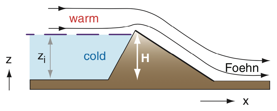
Chinook and Foehn
When the cold air layer is shallow enough that it is completely dammed behind the mountain range, then only the warmer-than-normal air at middle altitudes can flow over the mountains. But the suction behind the mountain brings the warm air down toward the valley. As this air descends, it is compressed by the increasing air pressure as it gets to lower altitudes, causing the descending air to warm at about 10°C for each kilometer is descends. (This dry adiabatic lapse rate is actually 9.8°C/km).
This phenomenon of a warm, dry, downslope wind is called a Foehn in Europe, and a Chinook in North America, and is sketched in the figure below. These winds can be strong enough to blow the roofs off of houses, so they can be a flight hazard and a landing/takeoff hazard.
There are not many photos of Chinook winds directly because it happens in clear air.
Foehns and Chinooks can also happen even without the initial cold-under-warm layering of air. For this to occur, the air approaching the mountain range must be humid, such as air approaching from over the ocean or large lakes. As this humid air is forced upward over the mountain range, the air cools, causing water vapor in the humid air to condense into water droplets. Much of this liquid (or solid) water falls out on the windward side of the mountain range (see the sketch below).
But the condensation process releases latent heat, causing the air to not cool as fast with increasing altitude as it normally would. However, when this air descends down the lee side of the mountain, it warms at the dry adiabatic lapse rate, causing it to be much warmer at location 6 in the diagram below than when it started at location 1. The net result is a warm, dry, downslope wind at location 5 on the sketch. When this happens in winter with snow on the ground, the warm dry air can evaporate the snow, nicknamed a "snow eater".
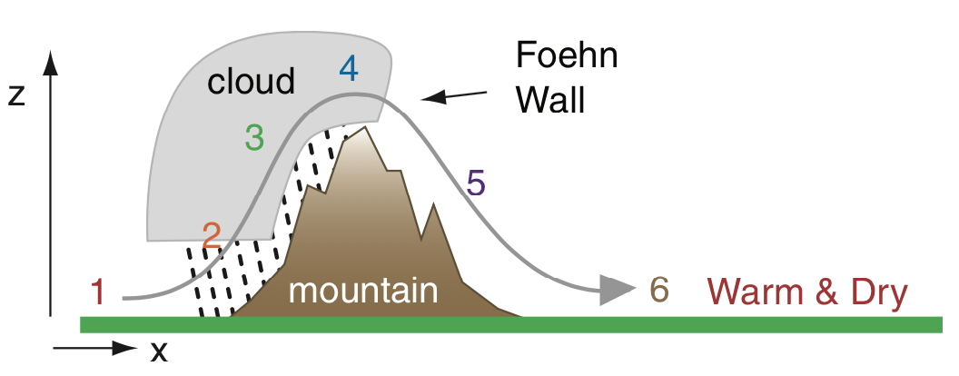
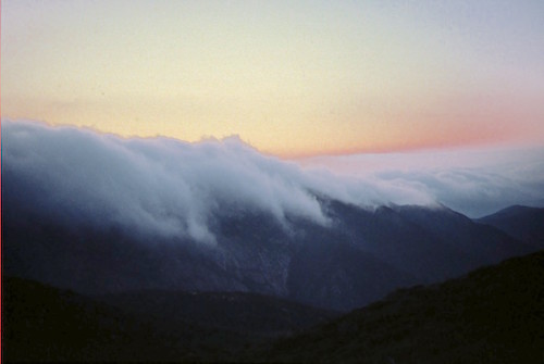
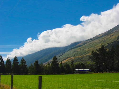
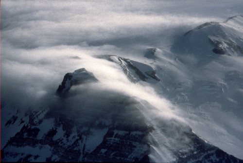
When viewed from point 6 looking back up toward the mountain top and the clouds at point 4, you would see a wall of clouds called a Foehn wall flowing over the mountains, where these clouds are evaporating as they descend and warm, as shown in the following photos.
 |
 |
 |
Here are some time-lapse videos of Foehn wall clouds:
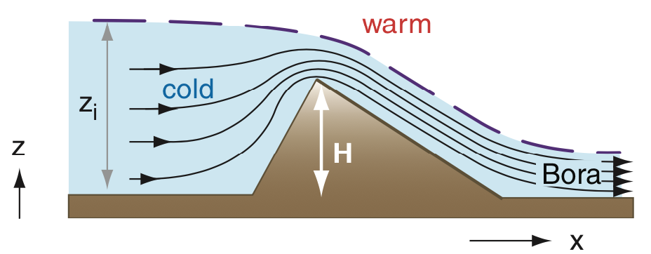
Bora
A bora is very similar to the first Chinook example, except that the layer of colder-than-normal air is deep enough so that the top of it is higher than the top of the mountain range (see the sketch below). This causes the cold air to spill over the mountain, creating a cool, dry, downslope windstorm.
Mountain Waves
Mountain waves are vertical oscillations of the air as it flows over mountains. They are discussed in much more detail in Learning Goal 3d, and mountain wave clouds (lenticular clouds) are described in Learning Goal 1b. So here we give only a brief overview of mountain waves.
Depending on how far from normal is the colder-than-normal air at low altitude and the warmer-than-normal air at high altitudes, different types of mountain wave phenomena can form, as shown in the sketch below. When the air layers have somewhat normal temperatures, the air flow over the mountains is as sketched in part (c) of the figure below.
If the bottom layer is slightly colder and top layer slightly warmer than normal, then the most violent downslope windstorms occur, as in figure part (b), where there are very fast winds down the whole lee side of the mountain. These strong winds can destroy houses and can roll trucks, and can cause airplanes to crash.
|
Aside I was flying traffic-pattern circuits practicing my takeoffs and landings (i.e., doing "touch and goes" ) in a small aircraft at Boulder, Colorado, airport just east of the Rocky Mountains, when a strong mountain wave began to form. The air became extremely windy and exceptionally turbulent. As I was approaching the airport to make another landing, another small aircraft in the traffic pattern ahead of me had just taken off when it suddenly fell out of the sky, killing both pilots on board. Needless to say, I decided to land and stay on the ground. But even taxiing was extremely difficult, as the winds kept trying to blow the aircraft over and push the vertical tail sideways. I finally taxied back to my parking spot, where luckily the airport provided strong chains to tie down the aircraft. |
But when the bottom layer is very cold and the top is very warm, then only a small amount of air spills over the mountain top and does not cause strong windstorms (figure part a).
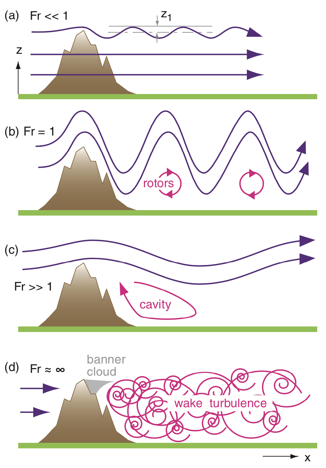
If the bottom layer is slightly warmer-than-normal and the middle
layer is slightly cooler-than-normal, then no mountain waves form at
all. Instead, there is obstacle wake turbulence behind the mountain, as
was discussed elsewhere in Learning Goal 3f.
Key words: dry adiabatic lapse rate, Foehn,
Chinook, bora, mountain waves, downslope windstorm, foehn wall
Extra info for experts; not needed for this course.
- YouTube: Explanation of Foehns.
Image credits. All the photos were taken by Roland Stull, and the drawings were made by Roland Stull, and all are copyright by him and used with his permission.