Thunderstorm Hazards > Downbursts, Microbursts, Gust Fronts & Low-Level Wind Shear
Learning Goal 4d. Identify thunderstorm hazards to flight &
how to avoid them. Downbursts & gust fronts.
Downbursts are rapidly descending downdrafts of air, found below clouds that have precipitation or virga (precipitation that evaporates before hitting the ground). The downbursts form when falling raindrops pass through drier air en route to the ground; if this air is dry enough, then water can evaporate from the rain drops as they fall. This evaporation cools the air (similar to the cooling you feel when you step out of the shower or bath). Because cold air is denser than the surrounding warmer air, this rain-cooled air is pulled downward by buoyancy force, with the descending air sinking faster and faster on the way to the ground.
Sometimes the downdraft speeds can be so fast (20 to 90 km/hr) that they are a hazard to aircraft. These fast downdrafts of air from thunderstorms are called downbursts, and can be 1 to 10 km in diameter. Those damaging downbursts with a small diameter (0.5 to 4 km) and short duration (2 to 5 minutes) are called microbursts. Here is a video showing a time lapse of a microburst: https://www.youtube.com/watch?v=a_G2KRzha7o.
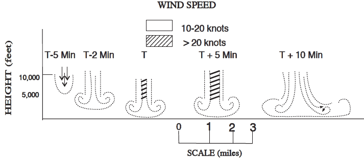
Evolution of a microburst. From FAA AIM section 7-1-26. T = time. (Note: 1 knot = 1.852 km / hr)
The next photo shows an example of a "wet downburst", where heavy rain from the thunderstorm is is falling through dry air near Phoenix, AZ.
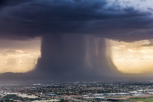
Wet downburst near Phoenix, Arizona, USA,
2016. Photo courtesy of Bruce Haffner, Chopperguy.com. Photographer:
Jerry Ferguson. Pilot: Andrew Park.
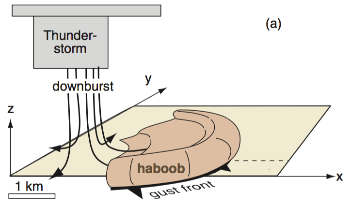
Also, when the cold downburst air hits the ground, the air spreads out as outflow winds in all horizontal directions away from the impact point. There is visual evidence of these ouflow winds by the shape of the downburst in the photo above. These radial straight-line winds can reach speeds of 125 km/hr — sufficient to cause damage to structures on the ground. The leading edge of these outrushing winds is called a gust front. (See YouTube video on downburst winds: https://www.youtube.com/watch?v=kFKzHg-5kko.)
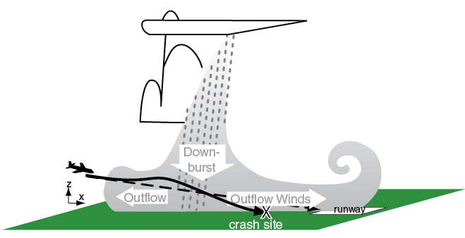
If the gust front advances over an airport (or if an aircraft flies through a gust front), there is a sudden change of wind speed and direction, known as low-level wind shear. This wind shear can cause different wind directions and speed over different parts of the runway, making landings and take-offs extremely challenging, as sketched above.
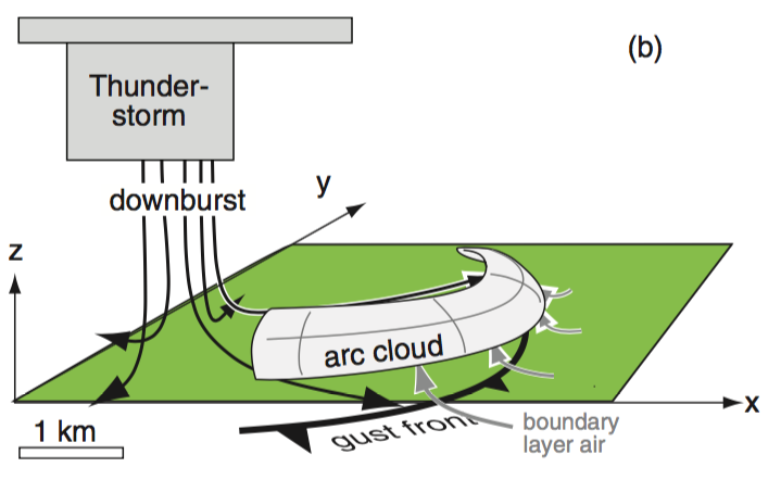
If there is sufficient moisture in the air hit by the advancing gust front, then a low-altitude cloud called an arc cloud can form along the curve of the gust front. In drier conditions, the gust front could stir up a wall of dust (called a haboob). The difference between the arc cloud and the haboob is that the haboob touches the ground, and dust or sand is in the turbulent outflow air. The arc cloud, on the other hand, does not touch the ground (although some can be relatively low), and consists of cloud droplets in the pre-gust-front warm air that was pushed up over the outflow cold thunderstorm air.
If present, the arc cloud or haboob is a good visual clue of a gust front.
| ARC CLOUD | |
|---|---|
 |
YouTube videos of
arc clouds (at leading edge of gust front):
|
| HABOOB | |
 |
YouTube videos of
haboobs (sand storms):
|
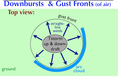
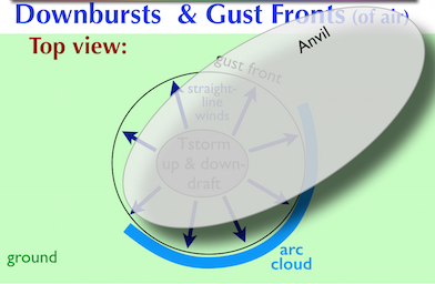
In the left diagram, the
dark
gray oval represents the violent core of the thunderstorm (Tstorm). The
right diagram is identical, but also shows the
anvil on the top of the storm.
Hazards to Aircraft
In addition to the violent turbulence caused by these phenomena, there are additional hazards to aircraft. A strong downburst can push an aircraft towards the ground, where the aircraft could impact buildings, trees, powerlines, or other structures. Also, the radial straight-line winds near an airport can cause wind shifts that make it very difficult to land or take off . (YouTube video of gust front hitting several light aircraft on the ground: https://www.youtube.com/watch?v=b_WmjWAGkLI)
Similarly, if an aircraft flies across a gust front, then the sudden increase or decrease of wind relative to the aircraft wings can cause the aircraft to unintentionally climb higher than the desired glideslope (the descending path toward the runway), or unintentionally sink below the glideslope toward impact with the ground. See these YouTube videos for some examples:
But don't worry — pilots are now trained to anticipate such violent winds to avoid accidents (YouTube instructions to pilots: https://www.youtube.com/watch?v=xIHFP4oHvds). For example, pilots might fly a bit faster toward the airport for landing, so that there is less threat that the aircraft wil get too slow and too low. Also, if the aircraft approach deviates too much from the desired glideslope, then the pilot will "go around" (doesn't land, but climbs back to the assigned altitude to try again later).
When thunderstorms and wind shears are present, the air-traffic controllers will alert the pilot that wind shear is detected, and if needed will tell the arriving aircraft to "hold" (temporarily fly a racetrack "holding pattern" in a less hazardous region of the sky) until the thunderstorm hazards have passed. Also, departing aircraft are held on the ground, and are not allowed to take off until the threat has passed.
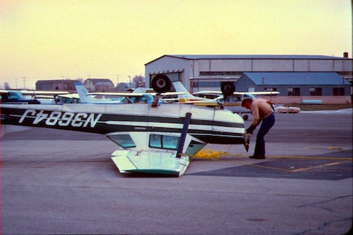
In a light general aviation aircraft, if you are parked at an
airport
where gust fronts or mountain waves can make strong winds at the
surface, then be sure to tie down your aircraft securely.
Key words: arc cloud, buoyancy, downburst, glideslope, goes around, gust front, haboob, holding pattern, low-level wind shear, microburst, outflow winds, straight-line winds, virga, wind shear
Extra info for experts; not needed for this course.
Downburst info for pilots:
- USA FAA AIM FAA AIM section 7-1-26.
- Canadian TC AIM, AIR-Airmanship, section 2.8 Low Level Wind Shear: https://www.tc.gc.ca/eng/civilaviation/publications/tp14371-menu-3092.htm
Image credits. All figures by Roland Stull, except where otherwise noted.