Aviation Weather Services
Learning Goal 4i. Access government sources of aviation weather observations, analyses, and forecasts.
Most of what we have covered until now has been on weather concepts and their application to aviation. These concepts are useful in many places around the world.
The new content below describes how you get current (live) weather data and forecasts, which varies from country to country. Here we focus on aviation weather services from the USA and Canada. If you are in a different country, you should do a web search to find out what aviation weather services are available to you.
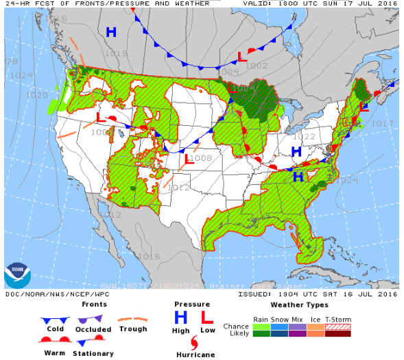
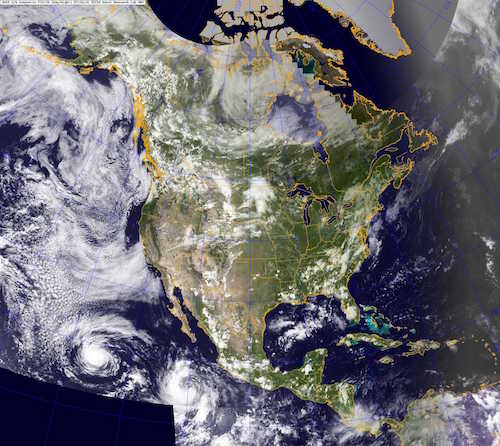
Samples of surface weather forecast (first photo, courtesy of the US NWS), and visible satellite photo (second photo, courtesy of the US Navy).
- In Canada, you can use the Aviation Weather Web Site (AWWS)
with data from NavCanada and from Environment and Climate Change Canada (ECCC).
- In the USA, you can access the Aviation Weather Center (AWC), which has aviation data from the National Oceanic and Atmospheric Administration (NOAA). Modern digital aviation weather data from the Data API is incorporated into many of the AWS products.
Much of this data is very technical and tailored to the needs of pilots. These technical details are NOT required for this course. Instead, I will give a quick overview of some of the different types of data, and where to find them on the web pages. You can click on the links below to see live (real-time) samples of some of the graphics products. (There are also detailed text products that are not linked here.)
For exams, just be aware of the different types of weather products available, as listed in the left column of the table below.
For example: satellite images, radar images, weather maps, weather forecasts, etc.
| Weather Product |
USA AWC & ADDS |
Canada AWWS |
|---|---|---|
| surface weather map (analysis & forecasts) — for the big picture overview of fronts, lows, highs |
Surface
, Detailed , Detail Zoomed |
Simple*, Detailed, Detail Zoomed , Pacific Ocean* |
| satellite images of clouds |
SatelliteA,
SatelliteB, Worldview , CSU GOES 16, CSU GOES 18, SSEC |
Satellite, Composite, GOES 18 zoomed on BC, |
| radar images of rain and storms |
Radar, BC WA OR* |
Radar, ECCC radar, BC WA OR* |
| regions of nice flying weather (VFR), not such nice flying weather (MVFR), and bad weather where pilots need to fly on instruments (IFR).
See Learning Goal 1g. |
Now,
Forecast |
Now & Forecast, Composite* |
| weather hazards overview map, including VFR vs. IFR, turbulence, icing, SIGMETs (warnings of significant weather hazards) |
Overview, Forecasts, |
Public Overview, Details |
| turbulence (from pilot reports, aircraft reports, and SIGMETS) |
Turbulence
|
Turbulence, GFA, local GFA |
| icing (from pilot reports, aircraft reports, and SIGMETS) |
Icing
|
GFA, local GFA |
| convection / thunderstorms (from various sources and radar) |
Thunderstorms
|
GFA, local GFA |
| ceiling and visibility |
Ceiling
& Vis. |
GFA, local GFA |
| wind and temperature at different flight altitudes |
Wind, Temp |
Upper Air, FD |
| pilot reports (PIREPs) and aircraft reports (AIREPs) of weather, made from aircraft in flight |
PIREP |
PIREP |
| airmans meteorological advisories (AIRMETs) and significant meteorological (SIGMETs) advisories |
AIRMET,
SIGMET |
SIGMET-mid, -high |
| volcanic ash |
International SIGMET , VAAC , Hysplit Research |
Volcanic Ash |
| current-weather observations at airports (METARs & SPECIs) |
METAR
|
METAR-text |
| weather forecasts at airports (TAFs) |
TAF
|
TAF-text |
* US data that is useful in Canada.
METAR - Aviation Routine Weather Report (or Routine Meteorological
Aviation Report, or Routine Meteorological Aerodrome Report)
The last two lines of the table above list METARs and TAFs.
Pilots use METARs to learn the
current observed weather
at their departure airport, destination airport, and other airports
near the flight track. METARs are text (not graphics) that are
coded using acronyms, abbreviations, and special formats. Pilots
can access these observations by computer or mobile phone while on the
ground, and can get it during flight by using the radio to talk to air
traffic controllers and flight service station specialists on the
ground. METARs are reported every hour, routinely. But what happens if the weather changes significantly between the routine reports. For that special case, a special report is issued, called a SPECI. It looks just like a METAR.
But METARs tell only the current weather, not the future weather.
TAF - Terminal Aerodrome Forecasts
TAFs are forecasts of the future weather,
produced by meteorologists using sophisticated computer simulations of
the atmosphere. Pilots can access these text-format TAFs the same
way that they get METARs. These are also coded using
special acronyms and formats. Luckily, the links above connect you to sites that also translate the METARs into plain English. Try it for the Canadian site METAR-text , typing in "CYVR" for Vancouver Airport, and selecting the "plain language" button before clicking "Get the bulletins". When I do it, I get a table of the past few METAR reports, where the top of the table shows the coded message and the rest of the table shows the decoded plain-English result. After the tables of METARS appears a table showing the coded TAF with the decoded result.
(For this course, you do NOT need to be able to code or decode METARs or TAFs. Just be aware that they exist, and that pilots can get these weather products. For the learning modules in this course, we will provide plain English METAR and TAF info when needed.)
None of the products listed above tell the pilot whether it is OK or safe to fly. The pilot must still gather the weather info for the flight and make a decision, given the often incomplete or conflicting data.
Key words: Aviation Weather Center (AWC), Aviation Weather Web Site (AWWS), METAR, TAF, SPECI
Extra info for Psychology Students
For those of you interested in the psychology of Aeronautical Decision Making see Chapter 2 pages 1 to 16 of the FAA "Aviation Instructor's Handbook".
Extra info for Pilot experts; not needed for this course.
- NavCanada has an Aviation Weather Services Guide (2017) —available for free as a PDF. 55 pages.
- An excellent user's guide: Aviation Weather Services, Advisory Circular, AC 00-45H — available for free as a PDF. 331 pages. It is updated every several years or so; AC 00-45H (2016) is valid at the time of this writing. Every US pilot should get a copy, because it explains how to interpret text products (METARs, PIREPs, TAFs, FAs, etc.), graphics products (including analysis and forecast charts, radar and satellite images), aviation hazards products (SIGMETs, AIRMETs, tropical cyclone and volcanic ash advisories, SIGWXs, icing and turbulence potential), and much more You can also buy printed copies of this advisory from online retailers.
- Also See FAA Aviation Weather, Advisory Circular AC 00-6B. https://www.faa.gov/documentLibrary/media/Advisory_Circular/AC_00-6B.pdf
Image credits. All figures by Roland Stull, except where otherwise noted.