Current – w22
The current table was taken from Fisheries and Oceans Canada’s ‘First Narrows’ current station. First Narrows is also known as Lion’s Gate Bridge, and is the narrowest point of Burrard Inlet as it passes between Stanley Park and the northern side of Vancouver. These currents are for Sunday and your travels back to Vancouver.
Source: Fisheries and Oceans Canada
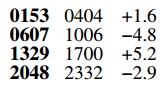
Caption: Current information for First Narrows. The first bolded column
gives you times for slack currents, the second column gives you times
for maximum currents, and the third column gives speed of the current
in knots.
Keep in mind that a flooding current would mean water coming into Vancouver (flowing west to east) under the bridge and an ebbing tide would be water flowing out (east to west) towards the Strait of Georgia under the bridge. I like to read the current table from top left to bottom right, e.g. “So, we have low slack at 01:53, reaching a maximum current coming in towards Vancouver at 04:04 of 1.6 knots (flooding, as indicated by the "+" sign), gradually weakening until high tide and high slack at 06:07. Then, the water started to flow in the opposite direction, away from Vancouver and out to the ocean (ebbing) reaching a maximum ebb (as indicated by the "-" sign) current of 4.8 knots at 10:06 am, then gradually slowing and coming to a complete stop (low slack) at 13:29…”, and so on.
What you need to consider is how fast the current will be flowing and in what direction at the time you intend to pass under the bridge. But note that these currents will also be present out in Burrard Inlet. How fast can your boat go under engine power? Are you going to be fighting against the current the whole way back, or travelling with it?