ATSC 113 Weather for Sailing, Flying & Snow Sports
Swell
Learning Goal 8d: Explain the parameters that need to be considered when forecasting swell from distant storms, and the affect of swell on sailboats.
Surfers will tell you everything you need to know about anticipating swell. They have it down to fine art. But really, all you need to know is the direction the swell is travelling, the wave height and period, and local conditions (wind and tide). These numbers will be presented to you in a swell forecast, but you need to know what they mean in order to use them. Here, I will describe how to anticipate swell from your sailboat, or from shore.
Recall from the previous learning goal 8a that swell
is a series of ocean-surface gravity waves created by distant storms
out at sea. These waves have the energy to travel (propagate)
long distances across the sea before reaching shores, where they are
dissipated by wave breaking or reflected back out to sea.
Swell Direction
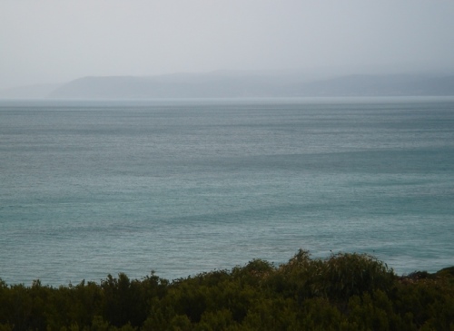
Source: dion gillard - originally posted to Flickr
as Ocean swell, CC BY 2.0, - https://commons.wikimedia.org/w/index.php?curid=4487407
The dark patches on the surface of the water show a series of waves,
‘swell’, coming in to shore.
Swell direction will be forecasted in degrees (as on a compass), with 0o being north and 180obeing south. The reported direction is where the swell is coming FROM. Knowing the swell direction is also important for knowing the angle at which the waves will approach your vessel or break on shore. If you are out on your boat, you could be getting swell from all directions, depending on your location. However if you are on shore and the beach you are standing on faces east, you can anticipate swells from the north east, east or south east, but will obviously not see any swell coming from the west.
If your boat is traveling parallel to the swell, it will be taking the waves side-on, which can cause your boat to roll violently from side to side or even capsize depending on the size of the swell. In a sailboat, it is best to be heading into the swell at an angle. You can also travel with the swell and wind behind you, in which case you’ll feel the boat ‘surfing’ the swell somewhat, but the boat will also roll considerably from side to side.
Wave Height and Period
Wave height, in conjunction with wave period, can give you a good idea of what kind of swell you will be seeing. These numbers will likely be from a weather buoy out at sea that measures the waves as they pass. For example, a forecast might say “Swell of 6 ft at 15 seconds,” meaning the swell has a wave height of 6 feet and a wave period of 15 seconds. Keep in mind that the buoys reporting these numbers are far out at sea, and will be more representative of what you will see if you’re out in your sailboat.
If you are on shore trying to predict how swell will break on the beach, the wave period can change what the swell looks like when it breaks. For instance, imagine a 6 ft swell with a wave period of 7 seconds. As the first wave hits the beach, the next wave is only 7 seconds behind it and doesn’t have a lot of time to build. It will likely break somewhere around 6 ft. However a 6 ft swell with a 15 second wave period has more than double the amount of time for a larger mass of water to build once the front wave starts to slow along the bottom. This wave could break as a 10 ft wave and will be carrying much more energy with it than the wave with a shorter wave period. A large wave height, or swell height, with a long period means good surf for surfers.
CAUTION:
Different countries report waves and swell in different units.
Canada (meters); USA (feet). If you use a USA website to
view swell info for Canada, the units might be feet. Be sure to
read the units as indicated on the maps or text messages.
Example of wave and swell forecast map from Environment and Climate Change Canada (ECCC):
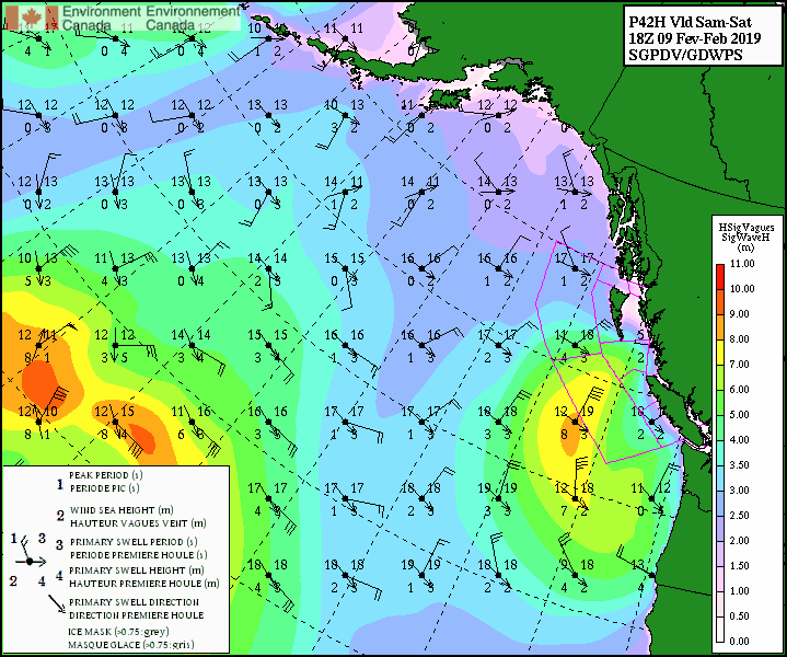
Real-time wave and swell forecasts:
- animated map from ECCC. https://weather.gc.ca/model_forecast/wave_anim_e.html?area=np&utc=00
Local Winds
Although distant winds may have created the swell you’re anticipating, local winds can also influence how the swell looks out at sea or how it eventually breaks on shore. Out at sea, strong winds on top of swell can create chop, or a confused sea. If you are on shore, there are two types of winds to consider: onshore wind and offshore wind. Onshore winds blow from the ocean onto the shore. This kind of wind creates chop on the incoming swell and can reduce the steepness of the wave. Offshore winds blow from the land out over the ocean. These winds tend to slow the speed of the approaching waves, smoothing the face of the wave before it breaks.
In the following picture, you can see how the onshore wind is blowing spray off the top of the breaker. These are not ideal surfing conditions, but some people still can’t resist.
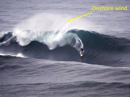
Source: Jeff Rowley - Jeff Rowley Big Wave Surfer Mavericks Left California 3of4 by XvolutionMedia 12 March 2012, CC BY 2.0, https://commons.wikimedia.org/w/index.php?curid=19513619
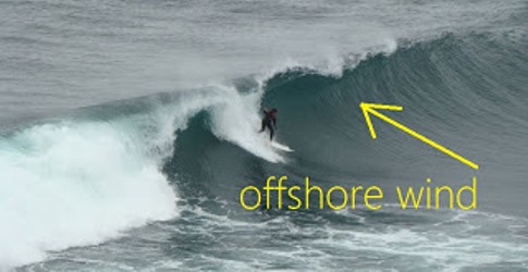
Source: Costa Rica Surf Institute - http://www.blog.costaricasurfinstitute.com/2012/03/surf-terms-defined-offshore-vs-onshore.html
Tide
The tide can also determine where a wave will break against the shore. As we’ve learned, waves start to break once they cross shallower water, and as the tide changes, the depth of water over the bottom and thus the contour of the seafloor beneath the wave changes.
For example, let’s say you have a long stretch of gradually sloping beach that drops off quite quickly closer to the mouth of the bay. When the tide is all the way in, the swell would be more likely to form spilling breakers due to the gradual slope of the bottom. When the tide is all the way out, the gradually sloping beach is now above water and the swell will break over the steeper bottom further out. This will cause the incoming swell to break as plunging breakers, rather than spilling breakers.
Swell Refraction
Imagine ice skating across a rink. When you drag your right skate, you’re creating frictional drag, and your body turns to the right. Incoming swell acts in a similar way. If a part of the wave hits shallower water sooner, or a reef or rock, it experiences more drag than the rest of the wave.
So, imagine an ocean swell travelling along a coastline that has a shallow reef close to shore. As the swell hits and starts to drag along the reef, the rest of the wave that is still in deep water will start to curve around towards the reef. This is swell refraction. Namely, the wave turns or refracts such that the wave crests become more parallel to the shoreline as the wave approaches the shallower water near shore. Swell with longer wave periods will refract more than short period swell. This can cause irregular breakers to form in areas you may not have been expecting.
Swell Decay
Swell decay is how quickly the waves lose energy (are attenuated) as they travel away from their initial source. Many factors can influence the rate at which swell decays, such as winds, currents, other waves, shallow water, and even the ocean’s own surface tension. Steeper waves with shorter wave periods decay more rapidly. However swell with long wave periods (and thus long wavelengths) have small wave steepness and can travel long distances across the ocean with little or no attenuation.
Additional Resources: (non-required material)
A mathenatical "Introduction to Ocean Waves", by Rick Salmon: http://www-pord.ucsd.edu/~rsalmon/111.textbook.pdf
Surfing Magazine Forecasts: https://forecasts.surfer.com/#place=48.28319289548349_-124.34326199999998_6_1418_height_none_terrain_-1
Swell decay tables: http://www.stormsurf.com/page2/papers/swell_decay.html
Keywords: swell, wave period, onshore wind, offshore wind, wave steepness, spilling breaker, plunging breaker, drag, swell refraction, swell decay.
Image credits are indicated near the figures.