ATSC 113 Weather for Sailing, Flying & Snow Sports
Global Wind Circulations
Learning Goals 9a:
- Identify the global wind circulations, including the Hadley cell, mid-latitude belt of extratropical cyclones, and Polar cell.
- Describe how the trade winds, westerlies, and easterlies are influenced by the Coriolis effect
Wind patterns exist at many different scales of motion, from the largest patterns over the whole globe, to winds associated with lows and fronts, to small turbulent eddies. All these scales are often superimposed on top of each other. In this section, we will focus on only the larger-scale (global) wind patterns at the earth's surface, as affect sailing large distances across oceans.
In meteorology, we often focus on three latitude bands in the
Northern Hemisphere, and similar bands in the Southern
Hemisphere. The figure below gives the terminology used for these
latitude bands, and for winds that blow mostly in the east-west
direction (zonal
winds), and winds that meander quite a bit to the
north and south (meridional winds).
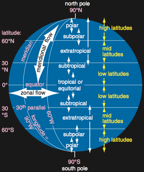
Figure. Terminology for weather in different
latitude bands on earth.
(Source: Stull, 2017: Practical Meteorology: An Algebra-based Survey of
Atmospheric Science. CC-by-nc-sa.)
Hadley cell
Sunlight heats the air in tropics more than the poles, causing a
temperature gradient (change of temperature across a distance) between
the equator and the poles. The warmer air near the equator rises
and creates a region of heavy rain and thunderstorms called the Intertropical
Convergence Zone (ITCZ), or the Doldrums.
Horizontal winds are are often light to calm, making it difficult to
sail at the ITCZ. This warm air rises to the top of the
troposphere, and spreads out toward the Northern and Southern
Hemispheres. But these winds get only as far as about 30°
latitude before they are turned toward the east (but still at the top
of the troposphere).
This turning is due to the Coriolis
effect
, which is related to the rotation of the earth. In the Northern
Hemisphere, the Coriolis force pushes to the right of the wind
direction. In the Southern Hemisphere, the Coriolis force pushes
to the left.
As air accumulates at 30° latitude, the pressure aloft increases,
and forces some of the air downward toward the ocean surface. Air
accumulates here, and creates a subtropical
high pressure zone
. This
is another region of light to calm surface winds where it is difficult
to sail. In the old days when sailing ships were becalmed in this
region, the ships often ran out of food and fresh water, causing any
animals such as horses on board to die. These latitude bands
became known as the horse
latitudes.
The descending air is very dry, so these latitude bands are where
deserts are favoured in both the Northern and Southern
Hemisphere.
As surface air blows back toward the equator, it is
turned to the right in the N. Hemisphere, and to the left in the S.
Hemisphere, due to the Coriolis effect. The result are the trade
winds (winds with a component from the east) over the ocean
surface. In the old days of sailing ships, trans-oceanic commerce
and trade could be conducted due to these winds -- hence their
name trade winds.
The figure below shows the Hadley cells.
Figure. Idealized global circulation for Northern
Hemisphere winter. The bulls-eye symbol indicates where a jet stream is
coming out of the page toward the reader, and the "X" with a circle
around it represents imagined tail feathers of jet-stream wind flowing
into the page. (Source: Stull, 2017: Practical Meteorology: An
Algebra-based Survey of Atmospheric Science. CC-by-nc-sa.)
Mid-latitude Cyclones
At mid-latitudes, such as Canada, there is not a strong vertical
circulation cell. Instead, the winds create large, horizontal
eddies or waves (see figure above). This is the latitude band of
swirling low- and high-pressure systems that we see on weather maps
(see figure below). The Coriolis effect causes the winds to rotate counterclockwise around
lows in the N. Hemisphere, and clockwise around highs. (Opposite in the S. Hemisphere.)
High-pressure regions (H), called anticyclones, are associated with fair weather, clear skies, but light winds (not good for sailing, but good for picnics and Ultiimate frisbee).
Low-pressure
regions (L), called extratropical
cyclones,
are associated with fronts, bad weather, and strong winds (not good for
pleasure sailing).
Often the best sailing at mid latitudes is in
between the highs and lows, where the winds are moderate and weather is
still OK.
At mid-latitudes is a general west-to-east air flow known as the
Westerlies. The mid-latitude Westerlies exist in both the Northern and Southern Hemispheres, but tend to be stronger
in the Southern Hemisphere since
they flow mostly over water (less frictional drag). Mid-latitude cyclones (Lows)
and anticyclones
(Highs)
are imbedded in a general westerly flow; hence, these weather systems
usually move from west to east.
The westerlies in both hemispheres are stronger in winter than in
summer.
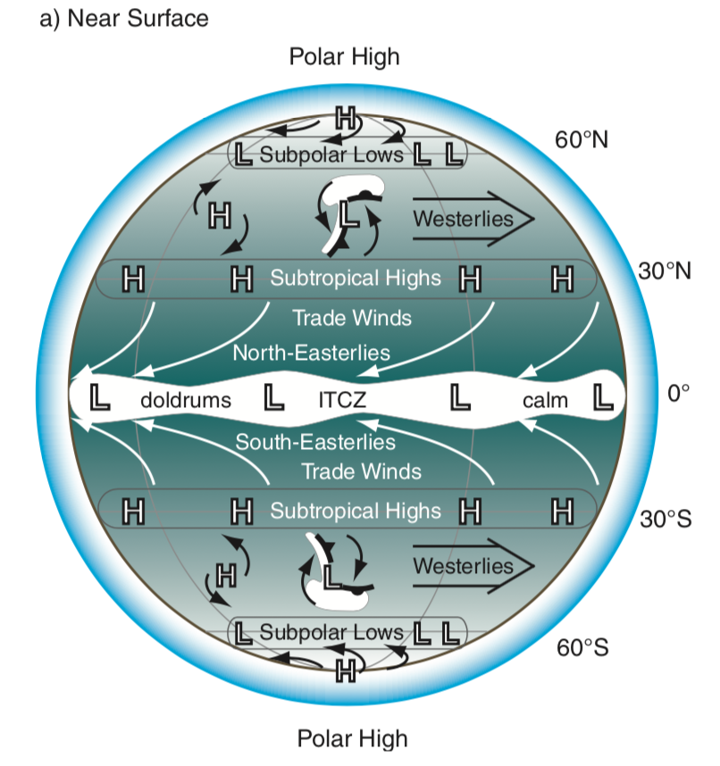
Figure. Surface winds around the globe, as is
useful for trans-oceanic sailing. L and H indicate low and high
pressure. (Source: Stull, 2017: Practical Meteorology: An
Algebra-based Survey of Atmospheric Science. CC-by-nc-sa.)
Polar Cell
The Polar cells occur between about 60° latitude and the poles. The air movements here are much weaker compared to those in the Hadley cells. The cool polar air meets the warmer mid-latitude air near the 60th parallel, where the warmer air rises over the colder air. This zone is known as the polar front. Here, winds blow from the east and north, shifting slightly east due to the Coriolis effect and are called the polar easterlies.
Summary
Near the earth's surface at mid-latitudes (such as the latitude of
southern Canada)
the prevailing winds are from the west . These winds are called
westerlies. Embedded within this general flow are extratropical
cyclones (lows) that are also blown from west to east by the prevailing
winds. But near these lows and their associated fronts, the local
winds can deviate from westerly - - the winds blow counterclockwise (in
the N. Hemisphere) around the low-pressure center. Also embedded
in the mid-latitude flow are moving anticyclones (highs) that are also
blown from west to east. But near these highs, the winds are very light, and rotation
is clockwise around the high center in the N. Hemisphere. Winds
rotation in opposite directions around highs and lows in the S.
Hemisphere.
Near the earth's surface at tropical (low) latitudes, the prevailing
wind is from the east. These are called easterlies, and are also
known as the trade winds. Embedded within this general flow can
be tropical cyclones (hurricanes, typhoons), which are also initially
blown from east to west by the prevailing easterlies.
The moving/traveling mid-latitude lows and highs are distinct from
the semi-stationary bands of high pressure at 30 degree latitude, and
semi-stationary bands of low pressure at roughly 60 degrees latitude.
Keywords: Coriolis effect, Hadley
cell, Polar cell, Intertropical Convergence Zone (ITCZ),
doldrums, subtropical high pressure zone, horse latitudes, trade
winds, westerlies,
polar easterlies, polar front, lows, cyclones, highs, anticyclones, zonal winds,
meridional winds.
Additional Resources: (non-required material)
Animation of Global Winds: https://earth.nullschool.net/
Videos: (non-required material)
Global Atmospheric Circulation: https://www.youtube.com/watch?v=Ye45DGkqUkE
Image credits: are given near the images.