ATSC 113 Weather for Sailing, Flying & Snow Sports
The Walker Cell and ENSO
Learning Goals 9c: Describe the phases of the El Niño-Southern Oscillation (ENSO) and how they affect the trade winds, ocean currents, and the Walker circulation.
This video provides an excellent overview of the material covered below.
Source: Stull, 2017: Practical Meteorology. Used with permission.
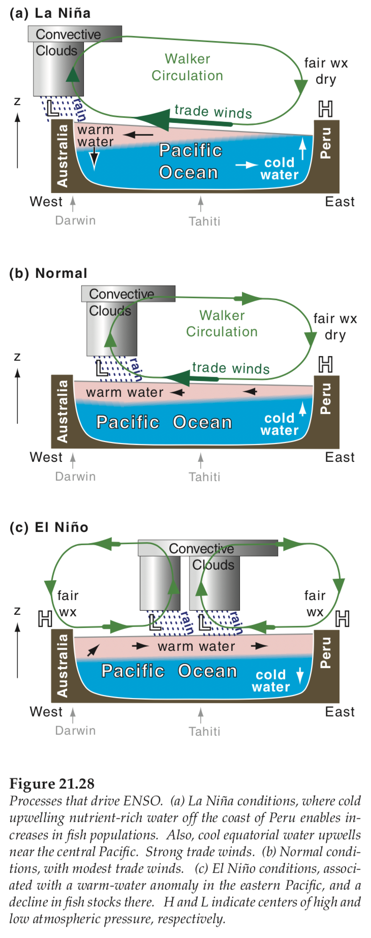
Walker Cell
In additional to the north-south circulations previously discussed
(i.e. Hadley, extratropical cyclones, and
Polar) there are other weaker east-west circulation patterns that can
signficantly affect the weather. The longitudinal (east-west)
circulation across the
equatorial Pacific is known as the Walker cell or
Walker circulation. We will start by looking at the "neutral"
phase (i.e., the normal middle phase) of this circulation.
(Neutral means not El Niño and not La Niña.)
The Walker cell is driven by temperature and
pressure gradients (see Fig 21.28b above). Areas of high pressure form over the cooler eastern
Pacific waters. Areas of low
pressure form over the warmer western Pacific. Winds near the equator flow from areas
of high pressure to low pressure, and so the near-surface winds cross the Pacific
move from east to west as part of the trade
winds.
These trade winds push some of the warm near-surface ocean water to
the west, helping to make the air temperatures warm there. The warm air
over the west Pacific rises and makes clouds, losing
its moisture as precipitation. The dryer air then travels back along the top of the troposphere towards
the eastern Pacific, creating a loop. This cool Pacific air then
converges with cool continental air and sinks along the eastern Pacific
coast. Because the air is cool and dry, there are fewer rainstorm
events in this high pressure region.
The Walker cell also drives longitudinal (east-west) air flows over the Indian Ocean and equatorial Atlantic Ocean, as sketched below.
In addition to the air circulations describe above, there are also ocean circulations associated with the Walker circulation (see figure 21.28b above). As warm near-surface ocean water is pushed from east to west, the deeper cooler water along the eastern Pacific coast rises to the surface to fill the gap. This is called upwelling. Once the cooler water reaches the surface, it is also blown across the Pacific towards Austral-Asia, warming along the way. The warm water is forced to sink once it reaches Austral-Asia (known as downwelling), where it is then drawn across the sea floor back towards the east.
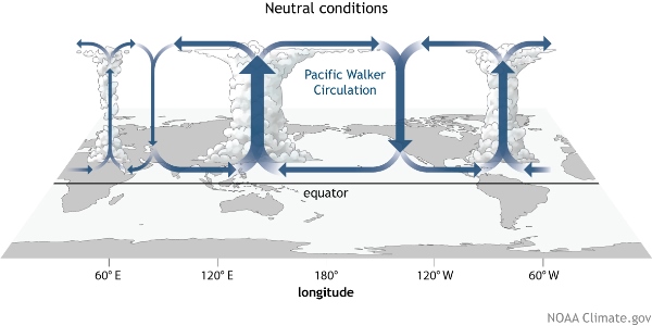
Source: NOAA Climate.gov drawing by Fiona Martin.
El Niño-Southern Oscillation (ENSO)
ENSO has three states: El Niño, La Niña, and neutral.
The neutral phase is the Walker cell functioning normally (Fig 21.28b above), while El Niño is the warmer phase of ENSO (Fig 21.28c above) and La Niña is the cooler phase (Fig 21.28a above).
El Niño
An El Niño phase occurs when the trade winds weaken (Fig 21.28c
above, and the figure below). Imagine blowing
water across your bathtub. As long as you’re blowing, the water
continues to move away from you and slighly piles up on the far side of
the bathtub as excess water. The moment you stop for a breath, the
excess water excess water surges back towards you, trying to make the
water surface level again.
A similar thing happens in the ocean. When the trade winds weaken, or even cease, the warm water from the western Pacific surges back towards the east and the upwelling of cooler water along the eastern Pacific coastline slows or stops entirely.
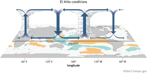
Source: NOAA Climate.gov drawing by Fiona Martin
La Niña
The La Niña phase occurs when trade winds are stronger than normal (Fig 21.28a above, and the figure below), causing increased upwelling of cool waters along the eastern Pacific and more cold water being pushed further across the Pacific.
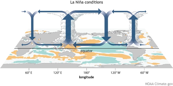
Source: NOAA Climate.gov drawing by Fiona Martin
Regional Effects of ENSO
These global oscillations can have significant effects on regional temperature and weather across the globe. It is important to know what phase of the ENSO you are in so you can prepare yourself for abnormal weather (where are the clouds and rain storms, where is the wind, what ocean currents and temperature might affect the fish you catch for food on your voyage). For instance, La Niñas can result in higher occurrences of fog due to increased upwelling along the coast. We will touch on fog again in Learning Goal 10e.
Don't memorize the figures below - - they are meant to just
illustrate how ENSO can affect your local weather. For example,
in Western Canada, ENSO does not have much of an effect in
summer. However, in winter, El Niño is associated with
warmer-than-average conditions, while La Niña is generally
cooler-than-average. Also, in the Vancouver area, La Niña can
also be wetter than average in winter, meaning more snow.
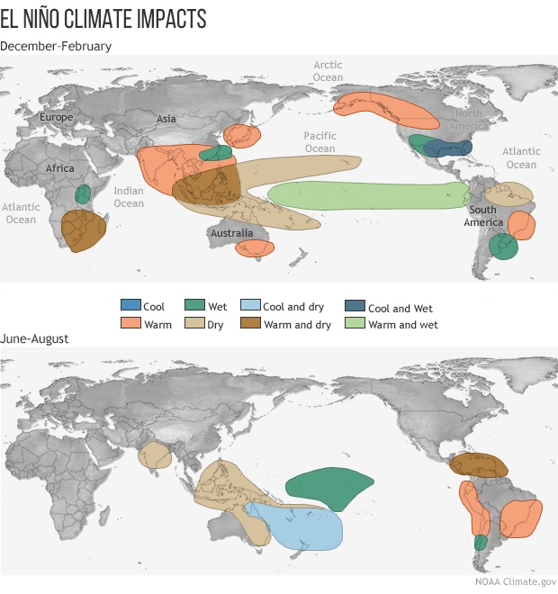
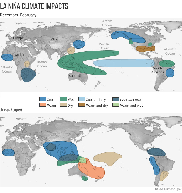
Source of the 4 images above: https://www.pmel.noaa.gov/elnino/impacts-of-el-nino , captured Feb 2019.
Additional Resources: (non-required material)
- Effects of ENSO on Canada: http://www.ocgy.ubc.ca/projects/clim.pred/enso.canada.html
- Effects of ENSO on Canada: https://www.canada.ca/en/environment-climate-change/services/el-nino.html#ENImpacts
- ENSO current state: https://www.climate.gov/enso
- ENSO Blog (with ENSO updates): https://www.climate.gov/news-features/department/enso-blog
Videos: (non-required material)
- ENSO explained: https://www.youtube.com/watch?v=WPA-KpldDVc
Keywords: Walker cell, trade winds, upwelling, downwelling, El Niño, La Niña
Image credits: are given near the images.