ATSC 113 Weather for Sailing, Flying & Snow Sports
Global Ocean Surface Currents
Learning Goal 9d: Explain the global ocean surface currents and gyres and how they are affected by wind.
Climatological Wind Patterns Worldwide
When the January pressure is averaged over 30 years, then the local weather variations associated with individual storms and fronts are smoothed out, and you are left with the climatological average. We could do the same for 30 years of Julys. The result is Fig. 11.31 below.
In this figure, the blue lines are isobars of equal pressure at sea
level. Centers of High (H) and Low (L) pressure are indicated,
and many of them are named (such as the Bermuda High).
Knowing these pressure patterns, we can anticipate the associated
winds (shown with brown arrows). Winds spiral clockwise OUT of
Highs in the Northern Hemisphere, and counterclockwise OUT of Highs in
the southern hemisphere. Winds spiral counterclockwise INTO Lows
in the Northern Hemisphere, and clockwise INTO Lows in the Southern
Hemisphere. Recall that the winds rotate around Highs and Lows
because of the Coriolis effect, associated with the rotation of the
earth.
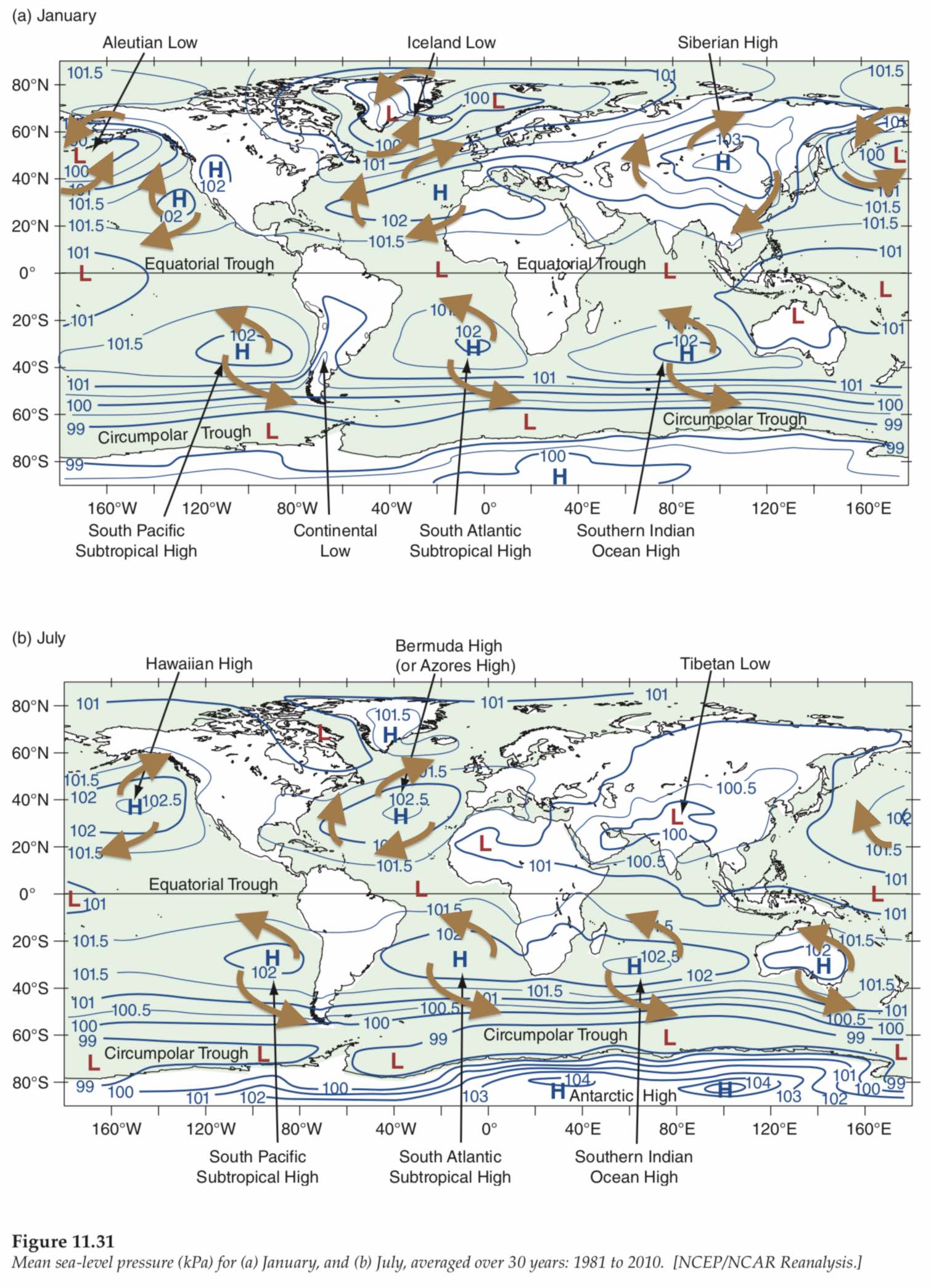
Source: R. Stull 2017: Practical Meteorology.
Used with permission. Length of brown arrows does NOT indicate
speed.
Ocean Currents Worldwide
The global ocean surface currents regulate the global climate. The oceans absorb a great deal of solar energy, and surface currents help to redistribute that energy around the world. The ocean currents carry warm water from the equator towards the poles, and cold water from the poles back towards the equator, making our planet’s climate more balanced.
Ocean surface currents transport water, as well as fish, plankton,
chemicals, thermal energy, plastic garbage, and rubber ducks across
vast distances. The next video shows how rubber ducks tell us
about wind-driven ocean currents.
Ocean-surface currents can also
help carry you and your boat long distances around the world! In fact,
if you look at the routes that sailors take when they race or
circumnavigate the globe, you will notice they travel with
the prevailing winds and currents to speed their journey.
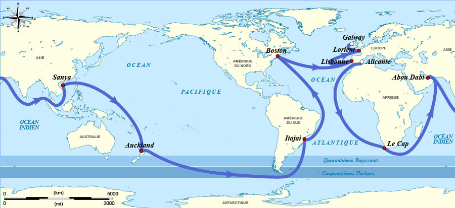
One Example: (non-required material)
As an example, look at this map of the Volvo Ocean Race for example. They start in Alicante, Spain, and travel with the wind and current all the way around the world and back to Scotland.
Source: Sémhur, Flappiefh - Golden Globe Challenge - 19690410 - map-fr.svg, CC BY-SA 3.0, https://commons.wikimedia.org/w/index.php?curid=26205337
Another Example: (non-required material) UBC Atmospheric Science graduate Eric Holden used his knowledge of meteorology and currents to win the Clipper Round the World race as skipper in 2014. https://www.youtube.com/watch?v=qHIN7Rd3kd0 . And: https://www.youtube.com/watch?v=qTIPAcerK1w . Also see his other work as navigator: https://www.youtube.com/watch?v=bT5u_FRewxo . And as solo skipper on the Oh Canada yacht: https://www.youtube.com/watch?v=3xkN_yn6ZDA .
The ocean’s surface currents are driven predominantly by frictional drag from the global winds, such as the winds we just learned about in previous learning goals (e.g. trade winds, westerlies, etc.). Their direction is also determined by the Coriolis effect, and Ekman transport.
If you look at the direction of the majority of the ocean’s surface currents (see figures below), you will notice a great similarity to the wind patterns we looked at earlier. That is because ocean currents are driven (in part) by winds. The north easterly trade winds push the North Equatorial Current across the Pacific from east to west and the northern westerlies push the North Pacific Current back across the Pacific from west to east. The temperature of the water affects the air pressure above it, which affects the winds, which in turn drive the ocean currents. It’s one big positive feedback loop.
We have already discussed how the rotation of the Earth causes the winds to turn to the right or left (the Coriolis effect). Well, Coriolis force has the same effect on the ocean. Surface currents in the Northern Hemisphere flow slightly to the right of the surface wind, and surface currents in the Southern Hemisphere flow slightly to the left of the surface wind. This deflection is what causes the ocean’s surface currents to form gyres that rotate clockwise in the northern hemisphere and counter-clockwise in the southern hemisphere.
Ekman transport also influences the direction of surface currents. As wind blows along the ocean’s surface, it has a diminishing effect on the water the deeper into the water you go, as was described in the "rubber duck" video. Each layer of seawater is pushed by the friction of the movement of the layer above it. So although a westerly wind could be pushing the surface water east, the drag throughout the water column results in a turning of the current with increasing depth. This turning is called the Ekman spiral. The average movement of water ends up being 90o to the right of the wind in the northern hemisphere and 90o to the left of the wind direction in the southern hemisphere.
There are five major gyres (circulating currents) in the ocean. These are the North Pacific, South Pacific, North Atlantic, South Atlantic, and Indian Ocean Gyres.
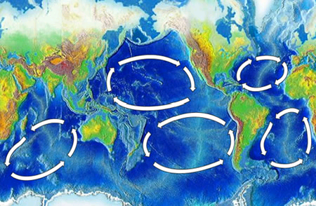
Source: NOAA - here, img, Public Domain, https://commons.wikimedia.org/w/index.php?curid=3830157
The water circulating through each gyre makes up the ocean’s currents. Let’s look at the North Atlantic Gyre, for example. Each gyre has a stronger western boundary current and a weaker eastern boundary current. In the North Atlantic Gyre, the Gulf Stream is the western boundary current, flowing fast, deep, and narrow along the eastern United States, bringing warm water with it. The Gulf Stream then turns into the North Atlantic Current, carrying that warm water from the US all the way to Iceland and northern Europe. Upon reaching Europe, the water continues south to northwest Africa. This is the eastern boundary of the North Atlantic Gyre and is known as the Canary Current (named for the Canary Islands). The water then flows along the North Atlantic Equatorial Current back across the Atlantic, completing the cycle.
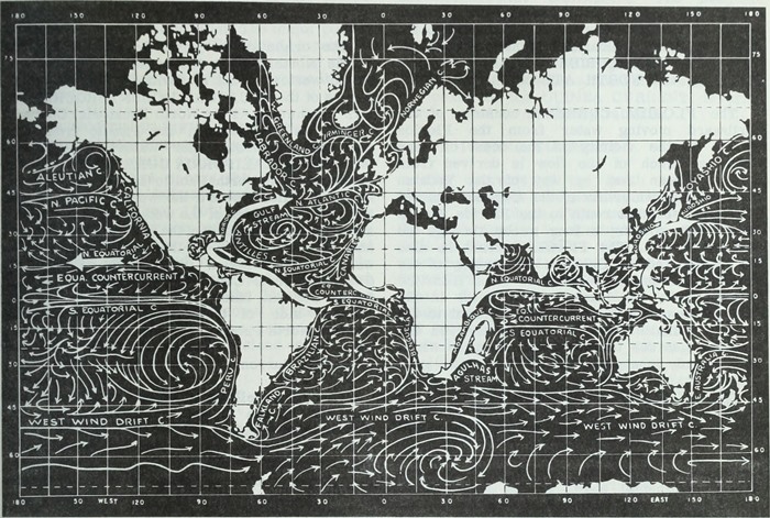
Source: Internet Archive Book Images - https://www.flickr.com/photos/internetarchivebookimages/17942647452/
Source book page: https://archive.org/stream/aerographersmate00nava/#page/n392/mode/1up
No restrictions: https://commons.wikimedorg/w/index.php?curid=43913256
The currents making up the North Pacific Gyre are the North Pacific Current along the north, the cold California Current along the coast of North America, the North Equatorial Current along the equator, and the warm Kuroshio Current along the coast of Japan.
As mentioned earlier, the trade winds push ocean waters towards the equator. These currents are called equatorial currents and flow more or less directly along the equator without deflection. This is because the Coriolis force is zero along the equator.
The water in the centre of an ocean gyre tends to be calm and unmoving. This is where you find the ocean’s garbage patches, with huge amounts of debris and garbage slowly getting sucked into the middle where it remains for years on end. This is a major concern with plastics, which degrade into micro plastics over time and are detrimental to the sea animals that consume them.
The European Space Agency produces a product that shows global ocean
characteristics including ocean-current speed, as shown in the figure
below.
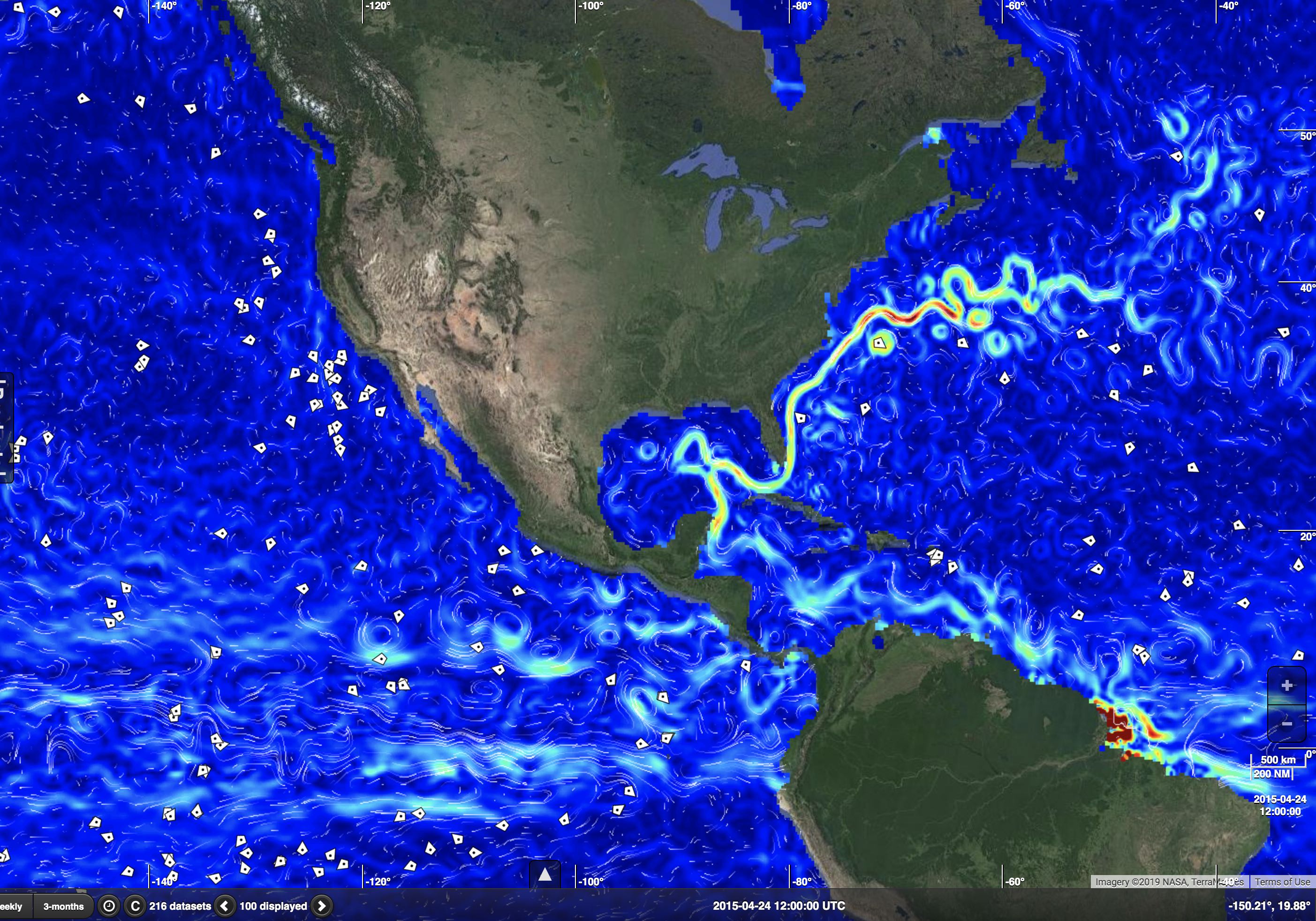
Source: http://www.globcurrent.org/ . Slower
surface current speeds are dark blue. Faster are lighter blue and
green. The fastest currents are red. The small white polygons are
locations of drifting buoys that make measurements of ocean conditions.
In this image, the Gulf Stream around Florida
and along the east coast of North America is clearly visible as a
ribbon of very fast ocean-surface current.
Currents on BC’s coast
The North Pacific Current flows from west to east across the Pacific, hitting North America near southern BC.
- See a nice map at: https://oceantracks.org/library/the-north-pacific-ocean/major-currents
This current carries warm water across the bottom of the North Pacific Subpolar Gyre and also the top portion of the North Pacific Gyre. The warm current then reaches Americas near southern British Columbia, causing relatively mild weather at Vancouver and other locations in southwest BC. The North Pacific Current then splits, with some water turning north as theAlaska Current (part of the North Pacific Subpolar Gyre) along BC’s north coast and Alaska. The rest of the water turns south to become the California Current (which is a relatively cool current compared to the subtropical waters further west of California).
Additional Resources: (non-required material)
NOAA’s Ocean Explorer – Ocean Currents: http://oceanexplorer.noaa.gov/edu/learning/8_ocean_currents/ocean_currents.html#slide
Ocean Surface Currents: http://oceancurrents.rsmas.miami.edu/
Videos: (non-required material)
NASA – The Ocean: A Driving Force for Weather and Climate: https://www.youtube.com/watch?v=6vgvTeuoDWY
Ocean Currents: https://www.youtube.com/watch?v=Hu_Ga0JYFNg
Garbage in the North Pacific Gyre: https://www.youtube.com/watch?v=Pbq5g73tkxI
Keywords: surface currents, drag, trade winds, westerlies, Coriolis effect, Ekman transport, gyre
Image credits: are given near the images.