ATSC 113 Weather for Sailing, Flying & Snow Sports
Hurricanes, Typhoons, & Tropical Cyclones
Learning Goal 9e: Describe hurricane structure, and how and where they form and move.
Climatology of these Storms
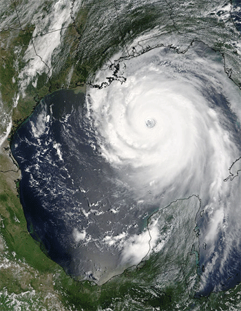
Source: NASA.
A hurricanes, also known as a tropical cyclones or typhoons in other parts of the world, are rotating storms about 150 to 300 km in horizontal diameter, and about 15 km thick in the vertical. They have extremely strong winds and high waves, so ==> all ships should avoid them <==.
- hurricane force wind and waves hitting a ship: https://www.youtube.com/watch?v=oiH-GsrihWw
- waves hitting cruise ships: https://www.youtube.com/watch?v=7UHgshcjNSw
- compilation of big ships in big waves: https://www.youtube.com/watch?v=cMNH4nmOims
Hurricanes form over tropical oceans having sea-surface
temperatures greater than about 26°C, because these high temperatures
cause very strong evaporation rates from the ocean into the air.
Thus, most hurricanes form between the
Tropic of Cancer (23.5o N)
and the Tropic of Capricorn (23.5o S), where the warmest ocean-surface waters are located (see first figure below).
- animation of sea surface temperature variations during the year: https://www.esrl.noaa.gov/psd/map/clim/sst.anim.year.html
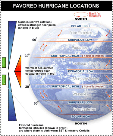
However, hurricanes cannot form at the equator, because Coriolis force is zero there. The Coriolis effect is what gives hurricanes their rotation, which is needed for storm longevity. As a result, the latitude bands that favour hurricane formation are indicated by the green bars in the second figure below.
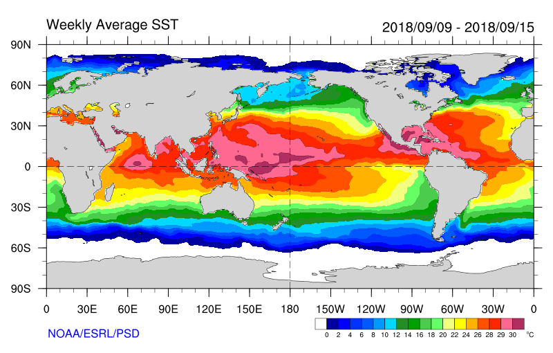
Source for figure above: NOAA ESRL PSD. https://www.esrl.noaa.gov/psd/map/clim/sst.anim.year.html
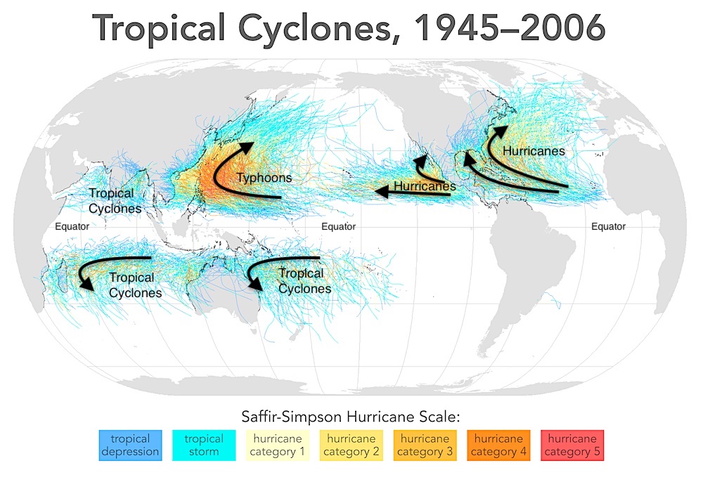
Tracks of hurricanes, typhoons & other
tropical cyclones during 1945 - 2006. No hurricanes at the equator. Attribution: Citynoise at English
Wikipedia.
https://commons.wikimedia.org/wiki/File:Tropical_cyclones_1945_2006_wikicolor.png
. CC BY-SA 3.0. Captured 15 Feb 2019, and annotated by R. Stull.
These storms typically form in the late summer and fall seasons, when the ocean surface is hottest. Thus, in the Northern Hemisphere, these storms are most frequent during 1 June to 30 November, with peak occurrence in August or September. In the Southern Hemisphere, these storms a most frequent during 1 November to 30 April. But in the Pacific, typhoons and tropical cyclones have been observed in every month.
If you are sailing in tropical waters at locations where these
storms are found, during months when these storms frequently occur,
then you should carefully monitor all cyclone predictions and warnings
via radio and satellite-internet and sail away from the path of these
storms. Hurricane/typhoon/tropical-cyclone prediction has a lot
of uncertainty, so it is best to stay well clear of the predicted paths
of these storms and frequently monitor the weather bulletins for updates.
Hurricane triggering, structure and evolution
Hurricanes start as clusters of thunderstorms over tropical
oceans. These thunderstorm clusters can be triggered several
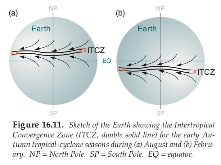
different ways. One triggering mechanism is the Intertropical Convergence Zone (ITCZ),
where the horizontal trade winds from the northern and southern
hemispheres converge (come together) force the air to rise to make a
band of thunderstorm clusters (see first figure below). Another
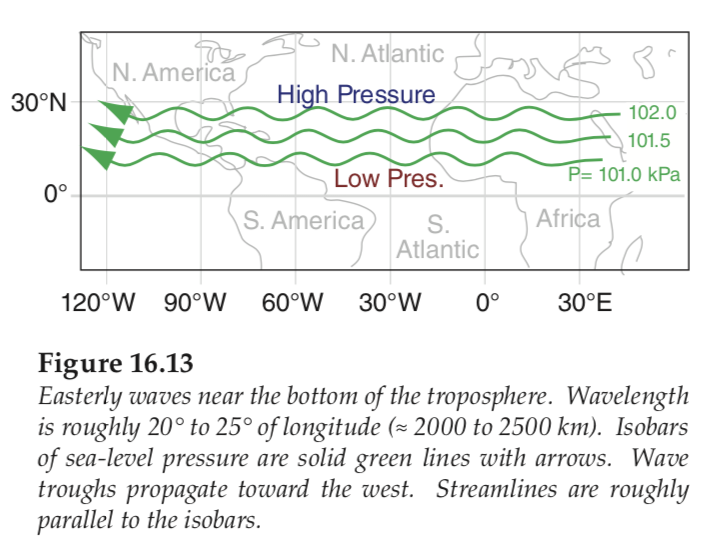
triggering mechanism are meanders (easterly waves)
in a low altitude (3 km above mean sea level) stream of fast moving air
called the African Easterly Jet (see second figure below).
Convergence of air triggers clusters of thunderstorms on the east side
of each crest (poleward meander) of the waves.
As water vapour condenses in these thunderstorm clusters, the
condensation releases latent heat, causing the stormy air to get
warmer. As more heat is released, the atmospheric pressure near
the tops of these storms start to increase, creating a pressure
gradient that drives air horizontally out of the top of the
thunderstorm cluster. This upper-level outflow is the "exhaust
system" for the storm, which removes some air molecules from the stormy
region. The net result is that the air pressure near sea level
begins to decrease, because of the less weight of air above.
A feedback occurs where this low-surface pressure under the thunderstorms will suck in more low-altitude, warm, humid air from outside the storm. This is the "intake system" or fuel supply for the storm, allowing the thunderstorms to intensify by causing more condensational warming of the core (center) of the storm, thereby creating faster outflow at the top of the storm (exhaust system). The first level of progression is a tropical depression, which has winds of 37-63 km/hr. As the storm intensifies, the tropical depression then becomes a tropical storm as winds continue to build to 64-118 km/hr, and once winds build beyond 119km/hr, the tropical storm becomes a hurricane (or typhoon or tropical cyclone).
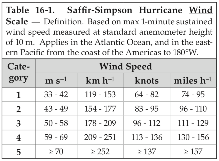
Hurricane intensity is classified according to the Saffir-Simpson
Hurricane Wind scale (see table below). Similar scales are used
to classify typhoons and tropical cyclones. (Compare this
classification with the Beaufort Wind scale from Learning Goal 8e.)
Source: R. Stull: Practical Meteorology. Used with permission.
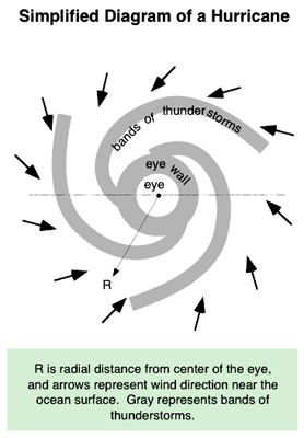
The hurricane usually has a well-defined "eye" with nearly calm winds, somewhat clear skies, and no precipitation. Surrounding the eye is an "eye wall"
of intense thunderstorms, which has the strongest winds and heaviest
rain. As near-surface air is drawn in toward the low pressure at the
eye of the storm, Coriolis force
causes the winds to turn to their right in the N. Hemisphere, or to the
left in the S. Hemisphere. As a result, the near-surface winds in
hurricanes spiral counterclockwise in the northern hemisphere and
clockwise in the southern hemisphere.
- Satellite loop of Hurricane Irma in 2017, showing storm rotation and movement: https://www.youtube.com/watch?v=ywQBfPtgEOM
Hurricanes are some of the most severe weather events experienced on the planet. Some of the worst hurricanes in history have claimed hundreds of thousands of lives.
When planning a sailing trip across the open ocean, it is important
to consider your course and how it relates to areas of hurricane
formation during hurricane season. It is also important to be able to
recognize conditions that could progress into a hurricane and avoid
sailing anywhere near these areas.
Swell
Hurricanes will also produce large ocean swell (recall Learning Goal 8d), which could reach you
days after the hurricane
has died down, or the swell could propagate ahead of the storm and
reach your sailboat before the hurricane arrives. Swell from
distant hurricanes can create large, dangerous waves close to shore.
Storm Surge
As hurricanes
approach land, the winds push large amounts of water up against the shore,
creating what is known as a storm surge
(a local rise in sea level). This mass of water can inundate (flood)
a coastline and destroy its
infrastructure (marinas, docks, port facilities). High tides, high
breaking waves, and onshore winds can increase the severity
of the storm surge. At coasts hit by hurricanes, boats at dock
are often destroyed and/or driven up onto the beach by the wind and
waves.
Additional Resources: (non-required material)
Earth Observatory, NASA – Hurricanes: http://earthobservatory.nasa.gov/Features/Hurricanes/
Videos: (non-required material)
Hurricanes 101: https://www.youtube.com/watch?v=zP4rgvu4xDE
For a more thorough description of hurricanes, see Stull, 2017: Practical Meteorology. https://www.eoas.ubc.ca/books/Practical_Meteorology/prmet102/Ch16-TropCycl-v102.pdf
Keywords: hurricane, tropical cyclone, typhoon, eye, eye wall, tropical depression, tropical storm, Coriolis effect, warm core, subtropical high pressure zone, storm surge, Intertropical Convergence Zone (ITCZ), trade winds, easterly wave
Image credits: Images from R. Stull, unless other sources are cited near the images.