ATSC 113 Weather for Sailing, Flying & Snow Sports
Wind and Current on the Water
Learning Goal 9g:
- Describe what different weather systems (ie. High and low pressure, warm and cold fronts) look like when you’re on the water; and
- Describe the effects that wind, tide and current can have on your travel speed and access to certain areas.
Now you know about the global circulation systems, how the atmosphere and the currents interact, and about some of the more dangerous characteristics of wind. The trick is going to be using this knowledge to plan your trip. Weather is hugely important to sailors. An unexpected change in wind or seas can greatly reduce how efficiently you travel across the water or even threaten your safety. You need to know what the winds and currents are going to look like ahead of time, and how to look for changing conditions once you’re out on the water.
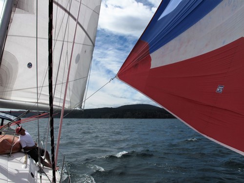
Sailing near a High-pressure center, with light wind and mostly clear skies. Source: Samantha James.
Surface Pressure Systems and Winds
If you know roughly where the high- and low-pressure systems are going to be during your trip, you can navigate through them more effectively, selecting for optimal winds and fair weather. High-pressure systems are typically associated with mostly clear skies and light to calm winds (see photo above) because you have warm, dry air descending. Low-pressure systems are typically associated with unfavourable weather such as rain, storms, and fronts, because you have warm, humid air rising and causing the water vapour to condense to form clouds.Sailing Tips
- Faster winds and higher waves are often found closer to the Low
center, and also near the fronts. Strong lows can be dangerous
for sailors.
- A
wide band of stratiform clouds with associated drizzle or snow
is often found AHEAD of warm fronts. Very low clouds and possibly
fog can occur at the warm front. After the warm front passes, the
skies clear and the winds are warmer. But often cold fronts will follow
behind warm fronts.
- A narrow band of thunderstorms (cumuliform clouds with lightning, gusty winds, very heavy rain, and downbursts) is often found along or just ahead of cold fronts. These squall lines were discussed in more detail in Learning Goal 9f. As the front passes, the temperature and humidity drops, pressure rises, and skies eventually clear. The winds usually shift from southwest to northwest (in the Northern Hemisphere), and you can expect a period of clear but cooler weather to follow.
- Away from fronts, the air can be clear or partly cloudy, but
winds can still be strong if there is a strong pressure gradient
(change of pressure across a distance) between High- and Low-centers.
- High-pressure centers have light to calm winds - - bad for
sailing.
- For long-distance sailing, it is good to pick a route around lows
and highs so that you have a tailwind, as discussed in the next
paragraphs.
Using synoptic-scale pressure patterns to good advantage
In the figure below, suppose you wanted to sail across the North Pacific
from Vancouver (point A) to Asia (point B).
BAD route: The
shortest route would appear to follow the green dashed line straight
from A to B. However, soon after starting from point A, you would
approach the center of the first High-pressure (H), where you would be
becalmed. So you would need to turn on your engine to get through
this region because there is no wind to fill your sails. Then, as
you approach the Low (L), winds would get so strong and stormy with
high waves that sailing would be very difficult, and you would need to
use reefed sails (reduced sail area) to not destroy your sail or your
mast or sink your boat. Then on to the next High (H) where you
would be stuck in calm winds again.
Conclusion: the shortest route is not necessarily the best or
fastest or safest route.
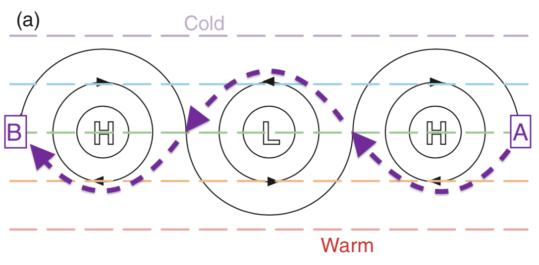
Sketch of synoptic-scale highs (H) and lows
(L) over the North Pacific Ocean. Wind directions are shown with the
thin black lines. Adapted from R. Stull, 2017: Practical
Meteorology.
GOOD route:
However, if you sailed following the thick dashed purple line, then
you would have nice tailwinds around the highs and the lows, allowing
you to "run" downwind. Between the highs and lows would be nice
crosswinds ("beam reach", see "Points of Sail" in the sailing basics
web page) that would provide fast and fun sailing. You would stay
out of the calm centers of the Highs, and you would stay far enough
away from the Low center to avoid most of the bad weather. Your
trip would be fun and fast.
Thought exercise: If you wanted to sail from Asia (point B) to Vancouver (point A) as plotted in the figure above, what path would you want to sail for the best speed and safety?
Cross-ocean and "round-the-world" skippers take good advantage of
the synoptic-scale weather systems (lows and highs), while trying to
avoid the difficult sailing near fronts. They also try to take
advantage of planetary-scale winds such as the trade winds at low
latitudes if they are traveling from east to west, or they take
advantage of the westerlies at mid-latitudes if they are sailing from
west to east. They are also avoiding
planetary-scale problem areas of calm winds such as the doldrums (near
the equator) and horse latitudes (near 30 degrees latitude). When
sailing, it is important to know where the highs and lows are and where they are moving, in order to know
how the wind is moving around them.
We will look at how to read these systems on weather maps later in Topic 11 on Marine Weather Services.
Wind and Waves
It’s important to remember that winds also affect waves. If the pressure gradient between high and low pressure areas is large, the winds will also be large. Large winds can create large waves and dangerous sailing conditions (remember ‘8e Beaufort Scale’). Winds travelling in the opposite direction of the waves can also create large choppy waves, or a confused sea state.
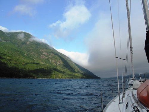
Sailing toward a front, with increasing clouds, wind, waves, and rain. Source: Samantha James.
Tides and Current
Missing the right tide or current can mean not getting to your destination when you planned or even entering dangerous waters. It is immensely important that you are familiar with the daily tides and the local currents of where you will be sailing (recall Learning Goal 9d).
For longer trips, sailors often use the global ocean currents to help carry them long distances. The global currents are steady and consistent. If you are sailing across the Atlantic, ride the Gulf Stream up to the North Atlantic Current and you’ll end up somewhere in Western Europe. If you were to aim straight across the Atlantic for northern Africa, you would be fighting the North Atlantic Equatorial Current and the trade winds the entire way. If you ever want to cross a current, you will need to account for the amount of drift you will experience (see ‘School of Sailing- Currents’ in the Additional Resources for an example of crossing the Gulf Stream).
For smaller trips, the tides will be more likely determine the direction of the current than the larger circulations. Timing your travel with the tidal current will make your trip much more enjoyable. We will look at local tides in greater detail in Learning Goal 10d, however for now, know that tidal currents vary in speed and direction, and travelling with the tidal current is favourable to travelling against it.
Travelling with the current can also help you save fuel if you’re driving under motor power.
This is a basic introduction of things to consider when planning a route. In the next set of Learning-Goal topics, we will introduce you to a few more pieces of the puzzle and provide you with some hands on tools to help you plan the optimal route. Finally, Sailing topic 11 will show where to get weather, tide, and current forecasts and how to interpret them.
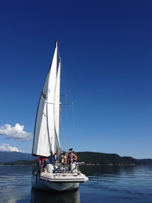
Sailing at a location between high and low pressure, with partial clouds and enjoyable winds caused by a moderate pressure gradiant. Source: Samantha James.
Additional Resources: (non-required material)
School of Sailing – Currents: http://www.schoolofsailing.net/currents.html
Video: (non-required material)
Sailboat struggling against fast current in Deception Pass: https://www.youtube.com/watch?v=4B3sd0XRFBE
Keywords: high-pressure system, low-pressure system, warm front, cold front, squall line, trade wind, tide, current
Image credits: are given near the images.