ATSC 113 Weather for Sailing, Flying & Snow Sports
Inflows and Outflows
Learning Goal 10b: Describe how inflow and outflow winds work in a coastal inlet
While synoptic weather (meaning large scale regional weather) determines the general wind patterns in British Columbia (BC), local land features can create localized wind patterns. The west coast of BC has numerous fjords and inlets reaching from the coast to the interior. These inlets act like highways carrying winds to and from the coast. These winds are known as inflows and outflows.
An outflow
is when air flow out from the mountains via fjords and valleys toward
the water. An inflow is when
air from the water is flowing into the inlets, fjords and
valleys.
In summer in fair weather, the daytime solar heating of the land and the mountains combines to create sea-breezes and anabatic winds that flow from the cool water toward the warmer land as an inflow. At night in summer when the earth's surface cools by radiating energy to space, the opposite happens where katabatic winds combine with land-breezes to channel colder air from the cold land to ward the water as an outflow.
In winter,
cold arctic air masses sometimes move into the BC interior, creating
strong high pressure east of the coast-range mountains. But lower
pressure is often on the other side of the mountains, over the Pacific
coast. The resulting pressure difference pushes air from the
interior of BC through the valleys and fjords to the coastline as a
very strong winter outflow wind. The leading edge of
a strong outflow can bring clouds, rain, or even snow with it,
followed by clear skies. Details of summer and winter inflows and
outflows are described next.
Summer Inflows and Outflows
Inflows typically occur in the spring and summer, when summer weather creates higher temperatures in the interior than on the coast. The pressure gradient reverses, causing the air to rush from the coast inland to the area of lower pressure. Although inflow winds are useful for sailors and wind surfers to know about, they are not usually strong. Outflow winds, on the other hand, can be stronger and hazardous.
The inflow and outflow winds are often named by local towns in the valley or fjord FROM where the wind first passes over the water.
Aside (not testable): Traditional Names for Local Winds.
Recall from our homepage: “We acknowledge that the UBC Point Grey campus is situated on the traditional, ancestral and unceded territory of the Musqueam People.”
The following message is from an English teacher at a Vancouver high school, the UBC Continuing Studies program, and a First Nation’s advocate for reconciliation:
"My uncle taught me a long time ago when we were fishing near his home in Alert Bay about the Nimpish wind and how the Namgis people wait for it to sail their longboats back, and always have. This is one of those winds of which the ATSC 113 course speaks about. We are from a different nation, but we respect other nations as well."
"The naming was done by the local First Nations, and European settlers named towns after these people when they began settling. "
"Thus, when we sail up the Salish Sea, we see the local winds, including the most famous Squamish winds. They were named as winds by these nations, not after towns which were also named after them, but as living entities under their beliefs, many thousands of years ago."
"As the towns are colonial enterprises, it suggests that is when the naming occurred, and perhaps even less sensitive in nature, by whom the naming was done."
"Perhaps the best way here is to also put these names into the appropriate language next to the anglicized version, using agreed upon and well accepted First Nation terms:
Qualicum wind (in Pentlatch language): Xwkwa’luxwum
Squamish wind (in Squamish Nechim - language): Sḵwx̱wú7mesh "
"The Westerlies coming across the Salish Sea are from the Great Tyee of the West, Sagalie to Coast Salish peoples. When they reach the "battle ground" off Pt. Grey, they face the cold wind from the North billowing down Howe Sound, the Sḵwx̱wú7mesh. Holmosom Rock off Wreck Beach is the point where the Creator deemed the battle to stop. To the West Sagalie is in command, to the East is the land airs, of the upriver and upland peoples, and to the North it is the Squamish which reverses track during its day."
"UBC campus is on Point Grey. The First Nations name for Point Grey is Elḵsn. English sea captain George Vancouver named the headland on his chart in 1792 after his friend, Captain George Grey.""Pauline Johnson, the famous Canadian poet of the late 19th and early 20th century, wrote of the First Nations legend of Point Grey:
https://www.legendsofvancouver.net/point-grey-vancouver "Source:
Stephen Culhane, PhD
English Department, Templeton Secondary
UBC Continuing Studies and Faculty of Education (retired).
Howe Sound is a fjord that is immensely popular with kite surfers (https://en.wikipedia.org/wiki/Kitesurfing) for its inflows and outflows (see image below). In the summer, Howe Sound typically sees outflows (called Squamish Winds because they come from over the town of Squamish, BC) over night and early in the morning, switching to an afternoon inflow. This is because overnight, the air over the Coast Mountains cools and becomes denser, falling through the mountains as a katabatic wind that gets channeled into a mountain wind that then passes out through Howe Sound. By about noon, however, the air over the BC interior will have warmed up and lost density, pulling the winds in from the coast.
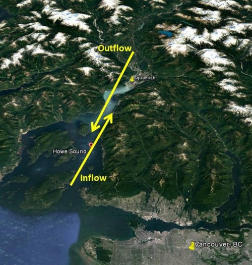
Inflows and Outflows through
Howe Sound, just
northwest of the city of Vancouver, BC. Source: Google Maps
annotated by S. James.
In summer, both the outflow and inflow winds can be strong. Here is a video showing very strong inflow winds in August.
- Porteau Cove to Squamish Yacht Race (fierce inflows!): https://www.youtube.com/watch?v=KpNZRRof3xU
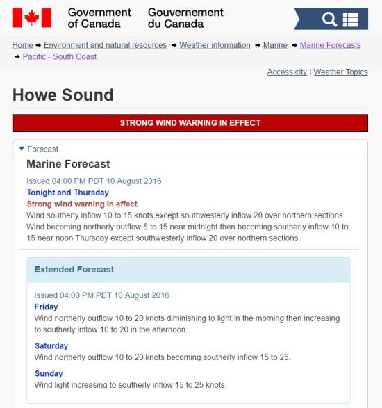
Here is an example of an Environment Canada weather warning (image below, for a different year, not for the video linked above) for the Howe Sound area for a late summer situation under sunny skies. Note the dramatic switch from morning outflows to afternoon inflows with stronger winds at the head of the channel.
The synoptic winds (meaning the larger-scale winds in the region) can also influence the strength of local inflows or outflows in summer. Often in summer there is high pressure and weak synoptic-scale winds over BC and the northeast Pacific Ocean. When these light synoptic winds blow from the south, they can build the strength of the afternoon inflows. However, if the synoptic winds are blowing from the north or northwest, they can diminish the inflow and strengthen the outflow. (Check out the yacht race video at the bottom of the page if you want to see some fierce inflow winds in Howe Sound!)
Another unique local wind system is the Qualicum wind on Vancouver Island. When a high pressure ridge forms on the west side of Vancouver Island, a southwesterly inflow funnels through Port Alberni Inlet, across the island through a gap in the mountains, finally emerging as strong outflow winds into the Strait of Georgia. Winds just off Qualicum Beach tend to be much higher than the surrounding areas during an inflow, and while the larger winds might be blowing down the Strait of Georgia from the north, strong westerly outflow winds will be blowing off Qualicum Beach. These outflow winds have sometimes torn apart the log booms pulled by tugboats down the Georgia Strait, when the tugs travel through the Qualicum outflow winds.
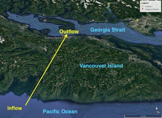
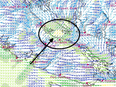
Winds (black arrow in the image above) are channeled from
the
Pacific Ocean past the towns of Bamfield and Port Alberni, finally
exiting Vancouver Island near the town of Qualicum (not shown, but it
is near the tip of the black arrow). Notice the Qualicum outflow
winds are 16-20 knots (yellow-orange coloured arrows) over the Georgia
Strait (near the center of the black oval), while the winds elsewhere
in the Georgia Strait are generally 2 to 8 knots.
When sailing, it is important to look at both local and regional wind conditions (see some of the weather resources below). Start with the regional forecast, and then look at local conditions for where you will be sailing. In Howe Sound, for instance, there are numerous kite surfing wind forecasts that will tell you what the inflow will look like that day. Or, you can try to figure it out yourself by looking at the temperature gradient between Vancouver and Lillooet to determine whether or not there is a big enough pressure differential to generate an inflow that day. When sailing up the Strait of Georgia, check the winds off Qualicum Beach and be aware that they could be abnormally high.
Another thing sailors should be wary of is crossing the inlet mouths. Outflow winds can come whistling down the inlet, creating strong winds and rough seas at the mouth, while seas might be calm and quiet further along the coast.
Winter Outflows
In winter, when a cold Arctic airmass is over central
British
Columbia, a strong high pressure often forms at the earth's surface
under the cold air. However, warmer air with lower pressure is
often just off the BC coast, over the Pacific Ocean. The figure below
shows a February example. The brown lines are the isobars,
connecting points of equal pressure.
A stationary front (red and blue line) is along the Pacific Coast (thin black line), marking the dividing line between colder air over land and warmer air over water. Higher pressure (H) is under the cold air east of the Coast Range Mountains, while Lower pressure (L) is associated with the warmer air over the ocean. The resulting pressure gradient is in the direction of the green arrows, which are perpendicular to the brown isobar lines.
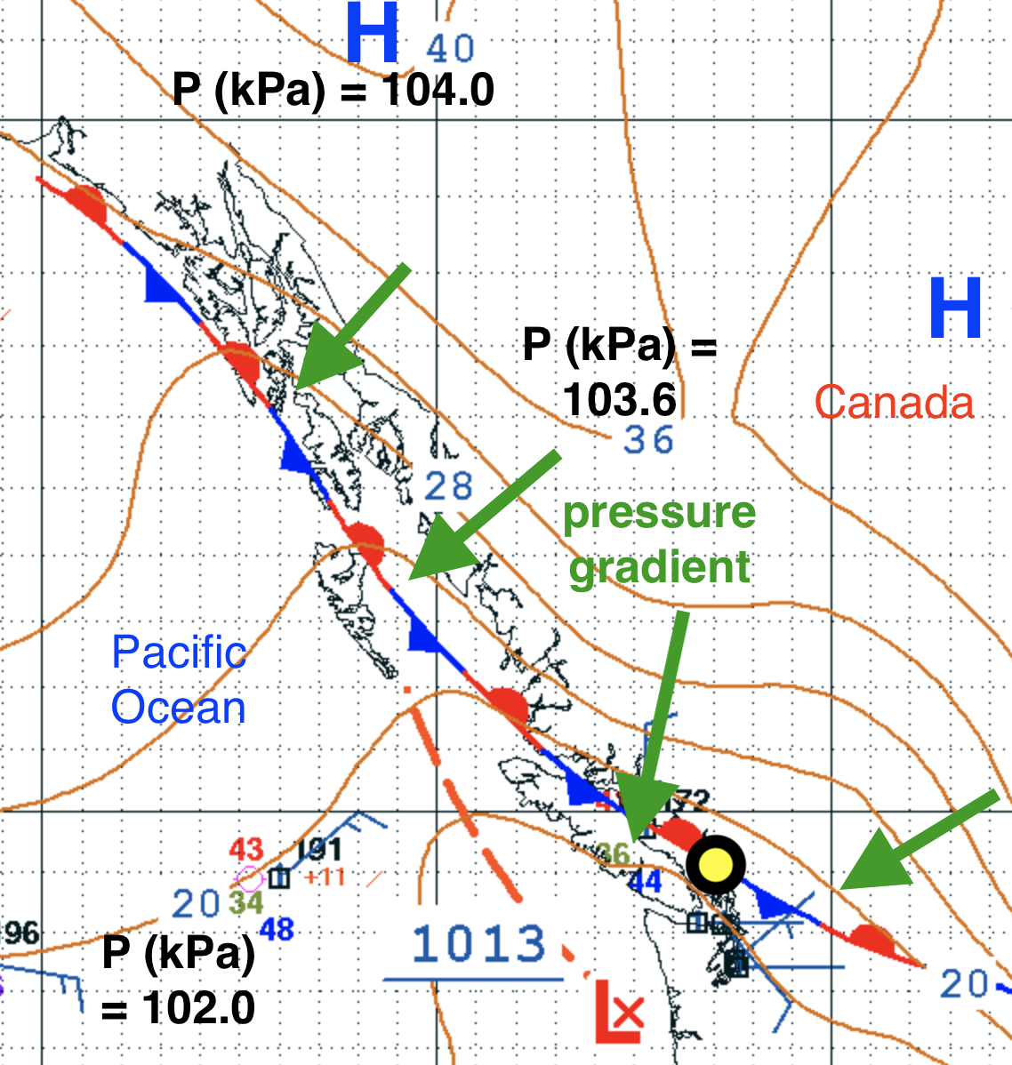
Source: NOAA Ocean Prediction
Center, annotated by Stull. 24 Feb 2019
https://ocean.weather.gov/Pac_tab.shtml
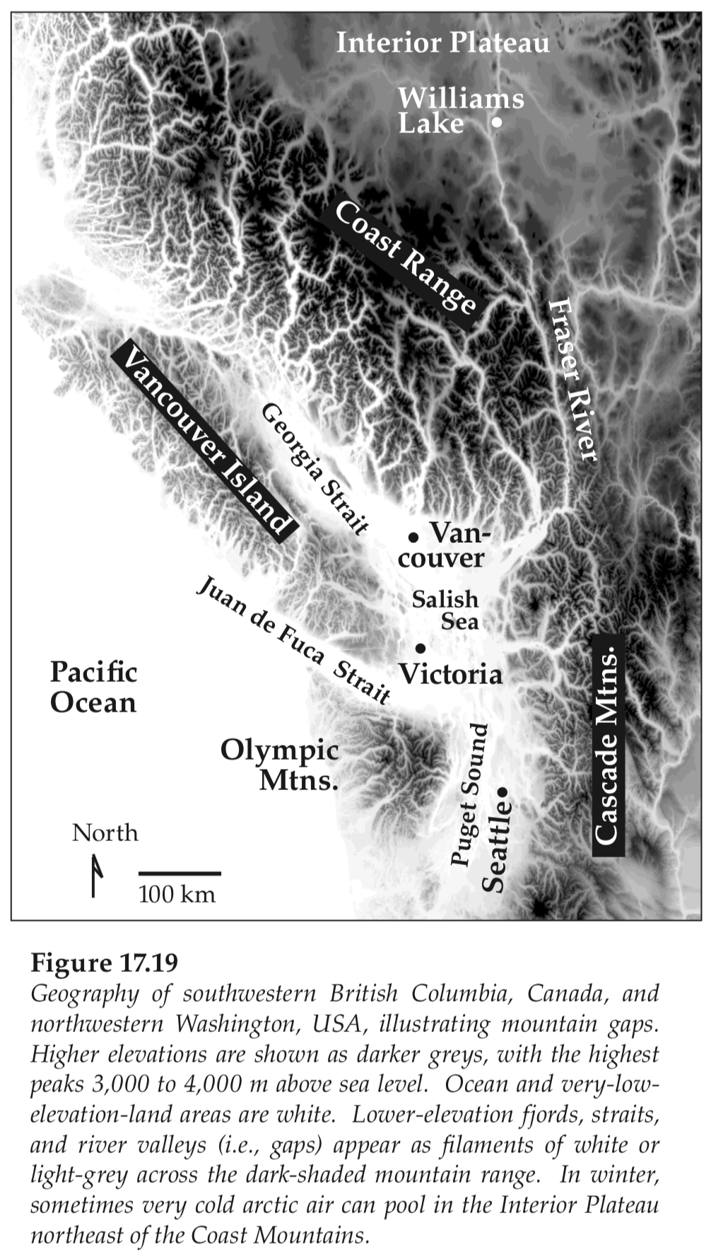
The but Coast Range Mountains (see figure below) right along
the
coastline act as a dam trapping the cold air in the interior of BC,
except where there are holes in the dam associated with valleys and
fjords. The figure below shows the higher mountains in the darker
colours, and the lower fjords and valleys as white or lighter
greys. The pressure gradient pushes the cold air through these
fjords and valleys toward the straits, sounds, and coast, to create
very strong outflow winds.
The net result in British Columbia is that cold air rushes
out of
the valleys and fjords towards the west, where it can create jets of
fast moving air over the water, disrupt shipping, sailing, and ferry
crossings. The figure below show the faster winds in red, orange
and yellow, and the slower winds in blue and green. You can see
the red colors (25 - 30 knots winds) spreading down Howe Sound and into
the Georgia Strait
(also known as the Salish Sea). There are also outflow winds down
the Lower Fraser Valley that sweep across the Georgia Strait towards
the Gulf Islands (northeast of Victoria) and towards parts of
Washington (WA) state including the San Juan Islands (which are popular
sailing destinations in summer).
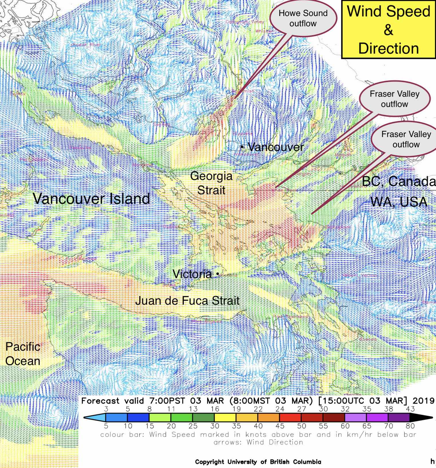
High resolution wind forecast produced by the Weather Forecast Research Team, directed by R. Stull, UBC. To see the outflow winds in more detail, here is a pdf of the same event, which you can zoom in your pdf viewer.
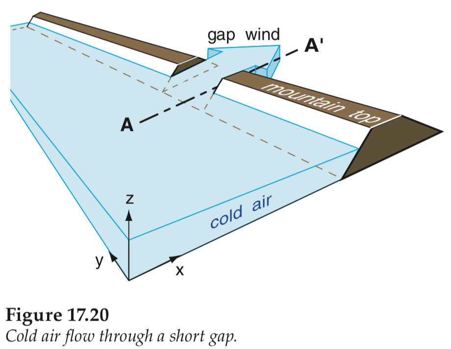
To get a different perspective, the sketch below is the view from over central BC looking southwest across the Coast Range Mountains toward the Pacific Ocean. The cold air rushing through the mountain gap creates gap winds that are the strong outflow winds over the ocean.
The winter example below, from February, shows an outflow wind WARNING for the Pacific central coast of British Columbia, where the outflow warnings are circled. Notice that the winds in this winter case are GALE warnings (with speeds up to 45 knots for this case), which are stronger than the summer case that was shown above.
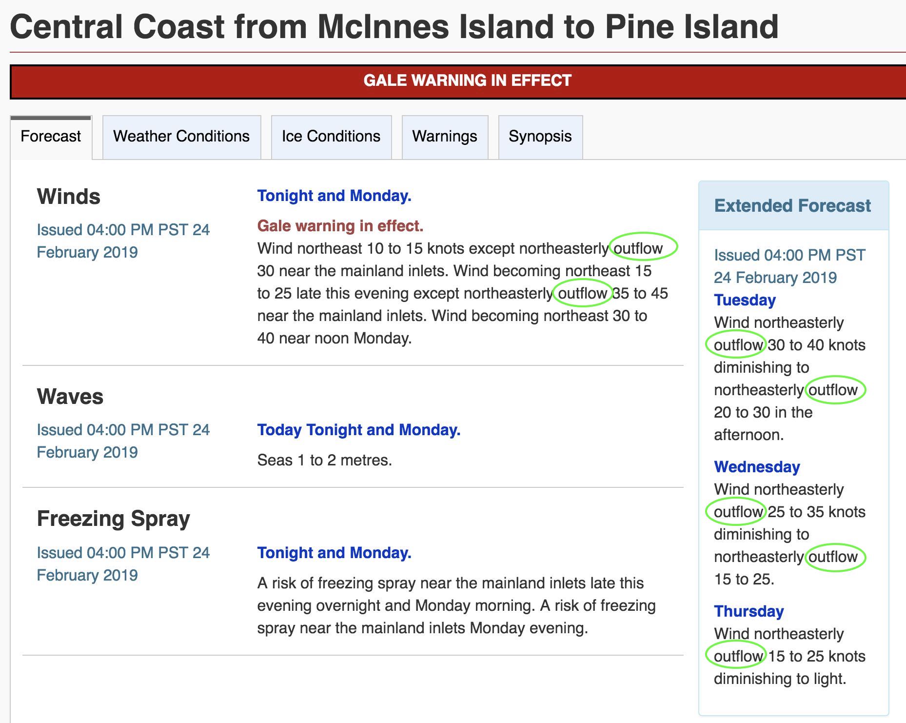
Source: Courtesy of
Environment and Climate Change Canada. https://weather.gc.ca/marine/
Additional Resources: (non-required material)
Seasonal Weather and Local Effects – BC: http://www.navcanada.ca/EN/media/Publications/Local%20Area%20Weather%20Manuals/LAWM-BC-4-EN.pdf
Wind Patterns in the Georgia Basin – the Salish Sea: http://depts.washington.edu/uwconf/2005psgb/2005proceedings/papers/E7_LANGE.pdf
Weather Talk for BC: http://wtfbc.ca/viewforum.php?f=11
Keywords: synoptic weather, inflow, outflow, synoptic winds
Image credits: Stull 2017 Practical Meteorology, except where otherwise given near the images.