ATSC 113 Weather for Sailing, Flying & Snow Sports
Mesoscale Cellular Convection
Learning Goal 10c: Identify areas of mesoscale cellular convection (open and closed cells) and horizontal roll vortices in satellite imagery and describe how they are formed.
Convection is the upward movement of warm air. Mesoscale cellular convection occurs in the
boundary layer between the Earth’s surface and the troposphere. It is
most common over the oceans behind cold fronts, where colder air from the continents blows
out over the warmer ocean air. This process is known as cold-air advection.
As warm air converges on the ground, it rises due to buoyancy a few kilometers and then hits a temperature inversion causing the air to spread sideways. An adjacent cell does the same and air aloft spreads until it hits the air spreading from adjacent cells. The converging air aloft between the two cells is then forced to sink back toward the sea surface. This pattern of convergence and divergence creates a honeycomb pattern of convective clouds that are recognized as open or closed cells.
Open cells have clear centres with surrounding by clouds, often in a honeycomb shape (adjacent hexagons of cloud rings). Closed
cells have convective clouds in the centre surrounded by clear sky.
Both are sketched below. Typical diameters of these cells are 10 to 50 km (which is a size called mesoscale), while their depth is
only 1 or 2 km.
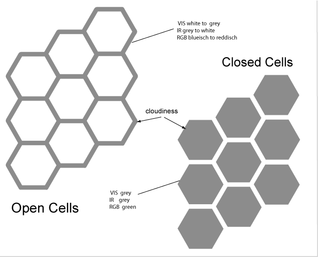
Source: image with permission from http://www.eumetrain.org/satmanu/CMs/OCC/print.htm
When looking at satellite imagery, it is easy to spot the
honeycomb-like convective clouds trailing behind a cold front.
The satellite photo below shows open and closed MCC over the Pacific
Ocean just southwest of Vancouver Island in February. The winds
on this day were blowing from the northeast toward the southwest;
namely, from the cold ground to over the warmer (unfrozen) ocean.
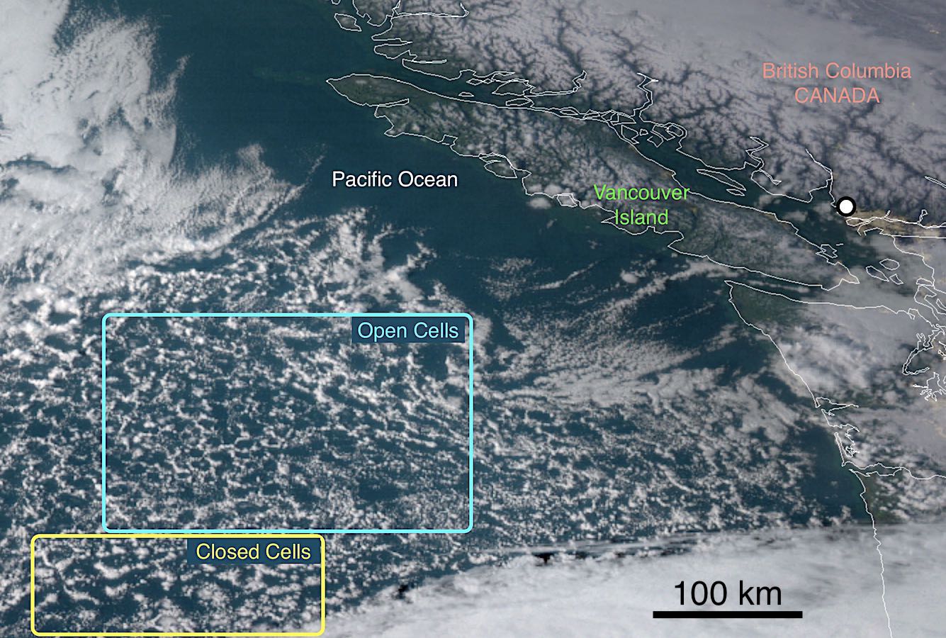
Source: NOAA/NESDIS/RAMMB.
Horizontal Roll Vortices
Horizontal roll vortices happen often when the following conditions are met:
- the synoptic-scale winds are light to moderate
- the earth's surface (or ocean surface) is warmer than the air, and
- cold-air is advecting under a strong temperature inversion.
Often these gentle roll vortices are invisible unless there are
clouds in the air. The gentle roll vortices sweep the rising
thermals and their associated cumulus clouds into parallel rows
called cloud streets. They are called cloud
streets because of the long rows of cumulous clouds that look like parallel streets or highways.
These are
similar to the open and closed convective cells; however, rather than
taking a honeycomb shape, the synoptic-scale wind causes them to form
long lines of cloud that are roughly parallel to the wind direction. Typical vertical thickness of each roll vortex is 1 or 2
km, and each pair of counter-rotating roll vortices has a pair width
about 3 times the vortex depth.
In the sketch below, the synoptic scale moderate wind speed (yellow
arrows) is blowing from bottom left to upper right in the figure; namely,
parallel to the horizontal rolls. In addition to that dominant
wind direction, sailors would notice the gentle left and right
crosswind components associated with the winds on the undersides of the
roll vortices.
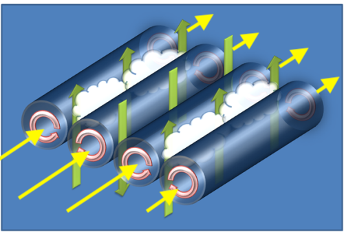
Source: Daniel Tyndall, Departmant of Meteorology,
University of Utah. - User created schematic, Public Domain, https://commons.wikimedia.org/w/index.php?curid=11974912 Annotated by R. Stull 2019.
Note the long rows of clouds that form as cold air is blown off the continent from the northwest toward the southeast over Hudson’s Bay, Canada:
Source: NASA Goddard Space Flight Center from Greenbelt, MD, USA - NASA Satellite "Drove Over" the Cloud Streets of Hudson Bay, CC BY 2.0, https://commons.wikimedia.org/w/index.php?curid=25673539
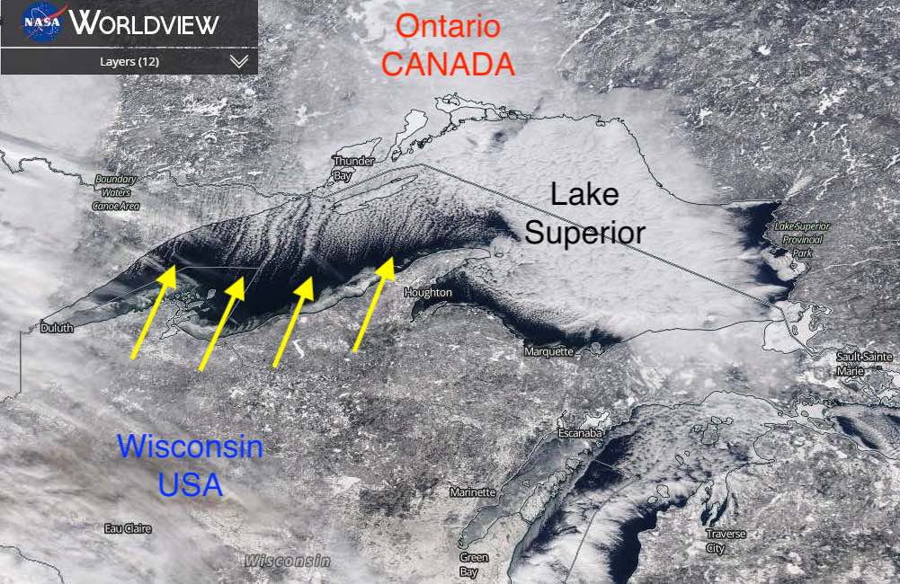
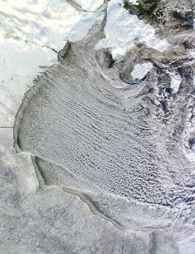
The cold air from Wisconsin is blowing (yellow
arrows) across the unfrozen Lake Superior (dark blue colour). The
lake is warmer than the cold air, so as the air travels further away
from the Wisconsin shoreline it picks up more moisture via evaporation
from the unfrozen lake. Eventually there is enough moisture in
the air for cloud streets
start to form about halfway across the lake. These cloud streets
continue a short distance into Ontario just north of Lake
Superior. Source: NASA Worldview polar orbiting satellites.
Additional Resources: (non-required material)
Open Cell Convection and Closed Cell Convection: http://www.eumetrain.org/satmanu/CMs/OCC/print.htm
CIMSS Satellite Blog – Open-cell vs closed-cell convection over the Pacific Ocean: http://cimss.ssec.wisc.edu/goes/blog/archives/4402
Meteorology Glossary: http://glossary.ametsoc.org/wiki/Mesoscale_cellular_convection
Wikipedia – Horizontal Convective Rolls: https://en.wikipedia.org/wiki/Horizontal_convective_rolls
Keywords: mesoscale cellular convection, cold-air
advection, convective clouds, inversion, open cell, closed cell,
cyclone, anticyclone, horizontal roll vortices, cyclones, anticyclones
Image credits: are given near the images.