ATSC 113 Weather for Sailing, Flying & Snow Sports
Weather Warnings
Learning Goal 11b: Access marine weather warnings and relate them to wind speeds and other hazards that could affect your voyage.
Environment & Climate Change Canada (ECCC) provides detailed information on weather warnings along with the marine forecast.
Not only can you access these data via internet while you are in port, most cross-ocean sailors also have satellite-internet receivers onboard to access the same data while at sea.
How to Get the Warnings
As mentioned in section 11a, the first
page you will come to when using ECCC’s marine weather forecast link (given above) is a map that
shows any regions with weather warnings in effect in red.
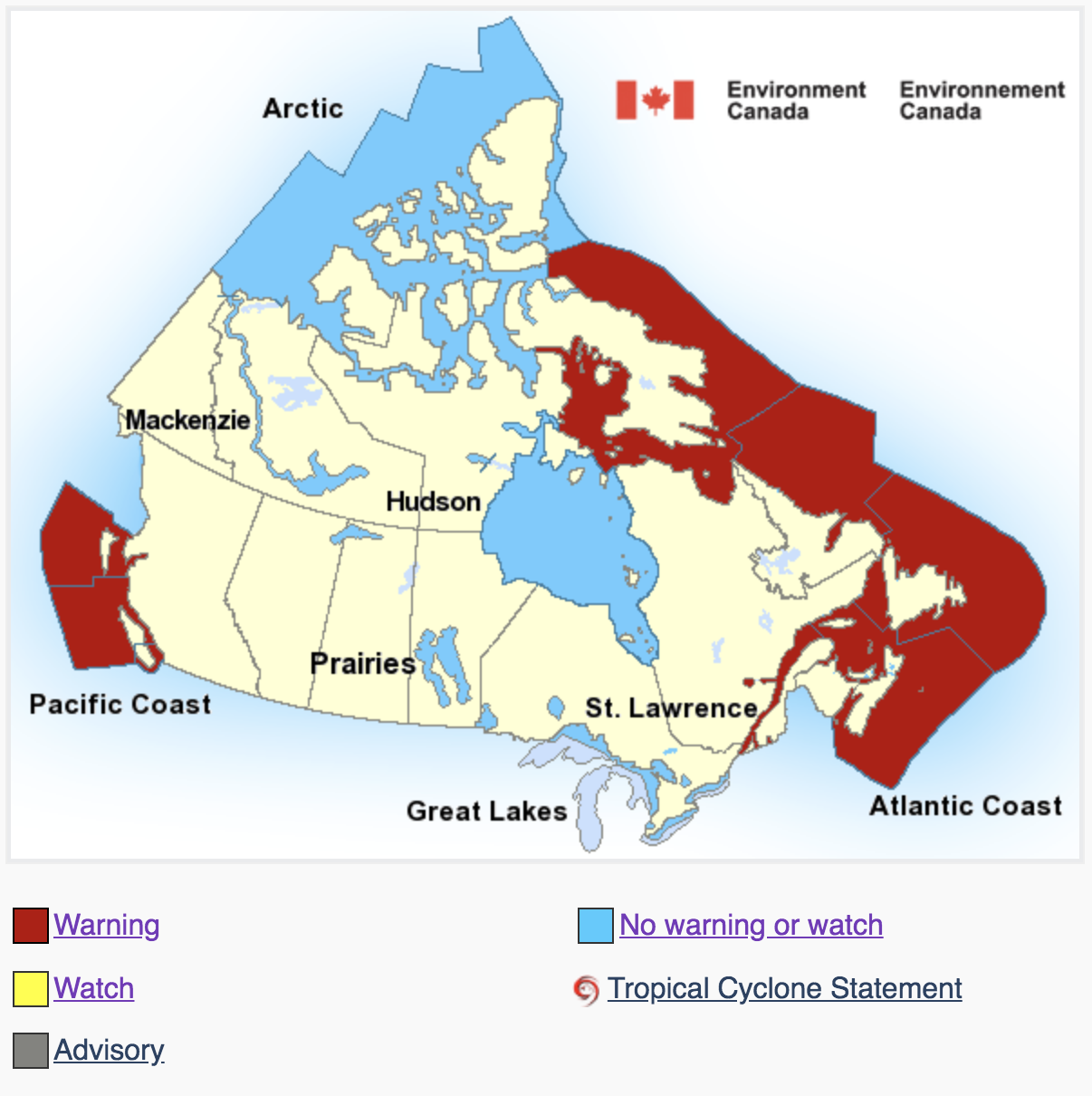
Map of Marine Warning Areas: Source: https://weather.gc.ca/marine/index_e.html
Next, when you click on any of the red areas in the map, it will zoom to provide a map with finer details of the warning areas, as shown below:
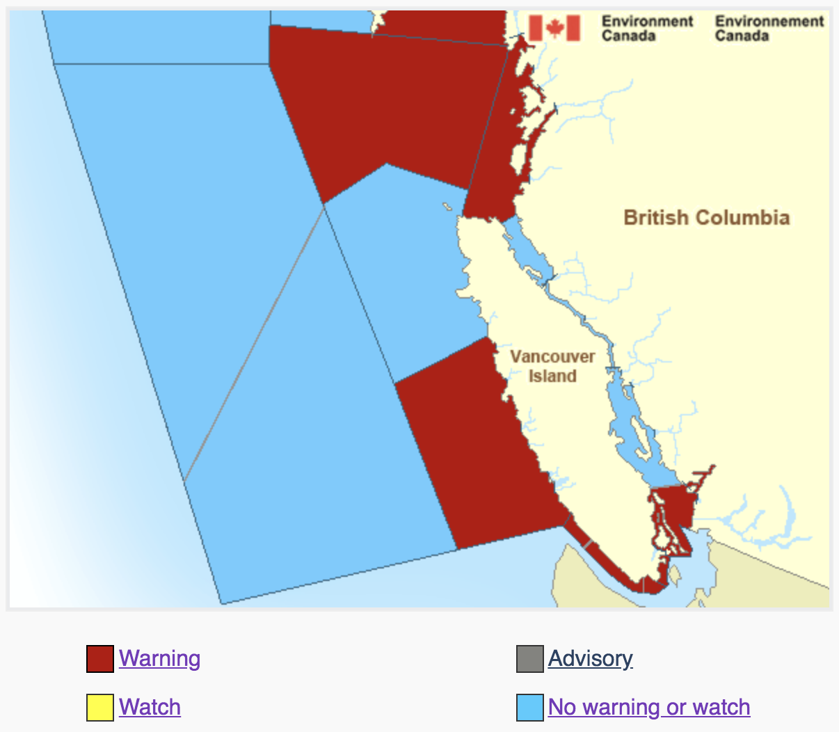
Map of Marine Warning Areas: Source: https://weather.gc.ca/marine/index_e.html
If you then click on a red area, such as the one shown on the west coast of Vancouver Island, you will get the details of the warning as shown in the following example:
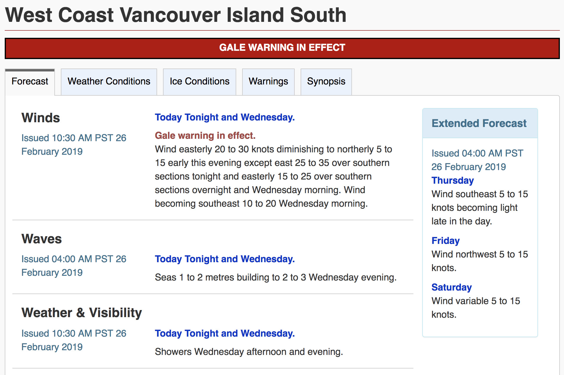
Example of Marine Warnings: Source: https://weather.gc.ca/marine/index_e.html
As a different example, below are warnings off the coast of Nova Scotia, in Atlantic Canada:
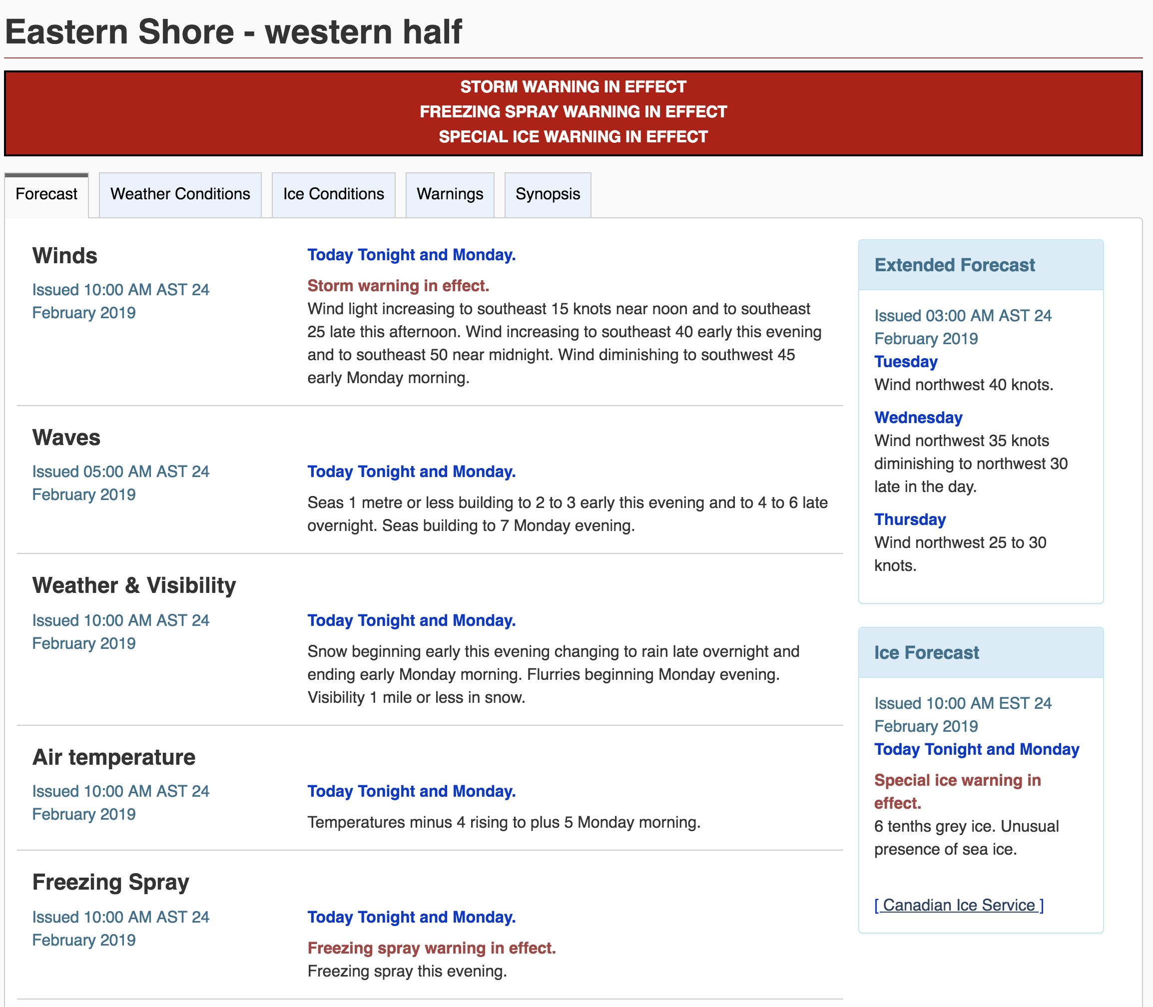
Freezing Spray:
When breaking ocean waves makes lots of sea spray (airborne droplets),
and when the air is very cold, the droplets can freeze almost instantly
when they hit a ship and its rigging, exposed cargo, or rigging.
This problem also happens in the Great Lakes, because the fresh water
sea spray can freeze at any temperatures below 0°C, compared to
salt-water spray that needs to be colder than about -2°C to
freeze.
The resulting ice can accumulate to dangerous thicknesses
because it makes the ships heavier (so they ride lower in the water)
and it makes them top heavy (so they tip over and capsize). Here
are a couple videos showing what freezing spray can do to ships.
List of Marine Warnings
Here is a list of the marine weather warnings and their associated wind speeds and hazards.
Synoptic Warnings:
- Strong Wind Warning: 20-33 knot
winds. Strong wind warnings are only issued for coastal or inland
waters during the recreational boating season.
- Gale Warning: 34-47 knot winds
- Storm Warning: 48-63 knot winds
- Hurricane Force Wind Warning: >64 knot winds
- Freezing Spray Warning: risk of ice formation on vessels due to low temperatures and strong winds
Notice that the wind speeds used for the marine weather warnings are the same as those used for the Beaufort Wind Force Scale (Learning Goal 8e).
As mentioned in Learning Goal 10b, the wind warnings will also state if they are associated with outflows or inflows.
- Tornado Warning: over the water,
regardless of whether it first formed over land or water
- Squall Warning: gusts > 34 knot associated with a squall line, or line of storm clouds
- High Water-level Warning: issued
only for Ontario and Atlantic Regions
- Special
Marine Warning: other hazards
- Waterspout Warning: given when a waterspout has been detected by radar or by observers (see Learning Goal 9f)
Localized Marine Watches:
- Tornado Watch. for possible tornado forming later in the day
- Squall Watch. for possible squalls forming later in the day
- Waterspout Watch. for cold-air waterspouts forming later in the day
- Special Marine Watch. for other potential hazards
NOAA Ocean Prediction Center (OPC)
For voyages across the Pacific Ocean, a good place to start for an overview of conditions is the Pacific Analysis weather map produced by the Ocean Prediction Center (OPC) of the US National Oceanic and Atmospheric Administratino (NOAA). You can find it at https://ocean.weather.gov/Pac_tab.php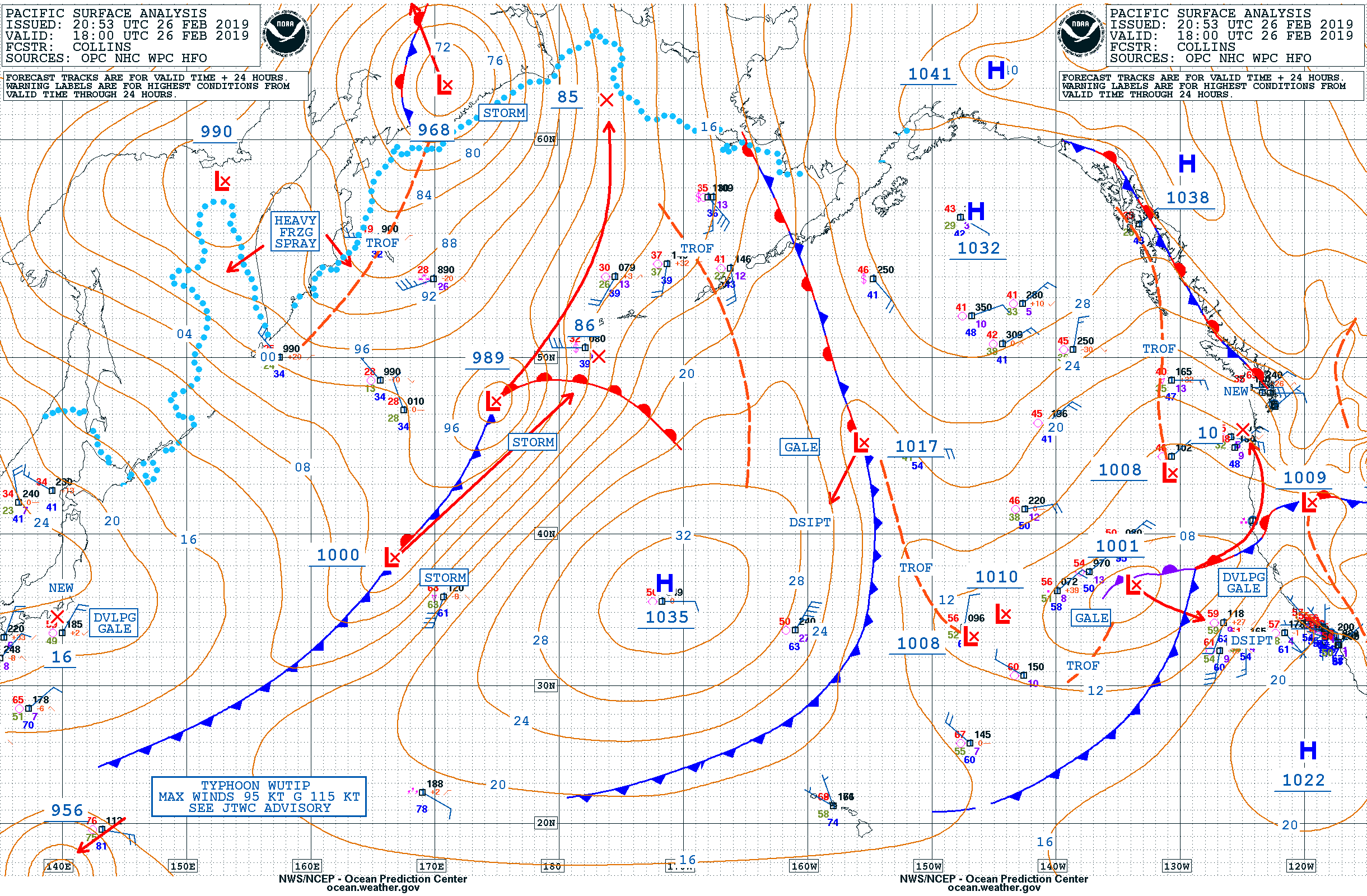
Example of weather map for the eastern North
Pacific Ocean. Source: https://ocean.weather.gov/P_sfc_full_ocean_color.png
We will learn how to read these weather maps in Learning Goal
11c.
But for now, notice that the example above also has warnings
highlighted with blue boxes. In addition to the GALE and
Developing
GALE warnings shown above, other warnings of these maps can include:
- DVLPG GALE (= Developing Gale)
- GALE
- DVLPG STORM (= Developing Storm)
- STORM
- HURCN FORCE (= Hurricane Force winds in an extratropical cyclone
that is not a tropical hurricane)
- TYPHOON
- STYPH (= Super Typhoon)
- HVY FRZ SPRAY (= Heavy Freezing Spray)
Additional sources of info across the Pacific are satellite images. These will be discussed in more detail in Learning Goal 11d.
Additional Resources: (non-required material)
- Guide to Marine forecasts for Canada: https://www.canada.ca/en/environment-climate-change/services/general-marine-weather-information/publications/guide-forecasts.html
- Marine Forecasts and Warnings for Canada: https://weather.gc.ca/marine/index_e.html
Keywords: strong wind warning, gale warning, storm
warning, hurricane force wind warning, squall warning, freezing spray
warning, waterspout warning, tornado warning
Image credits: are given near the images.