ATSC 113 Weather for Sailing, Flying & Snow Sports
6 - Snow Sports: Winter Mountain Weather
Learning Goal 6b: Describe the diurnal evolution of slope flows
A diurnal process is one that happens on a daily basis. A diurnal slope flow is induced by thermal (temperature) changes over the course of a day, as a result of the sun heating the earth's surface (which in turn heats the air above it), and then the earth's surface cooling after the sun sets (which in turn cools the air). This diurnal cycle is most pronounced when under the influence of a high pressure system, with fair weather and calm or light winds.
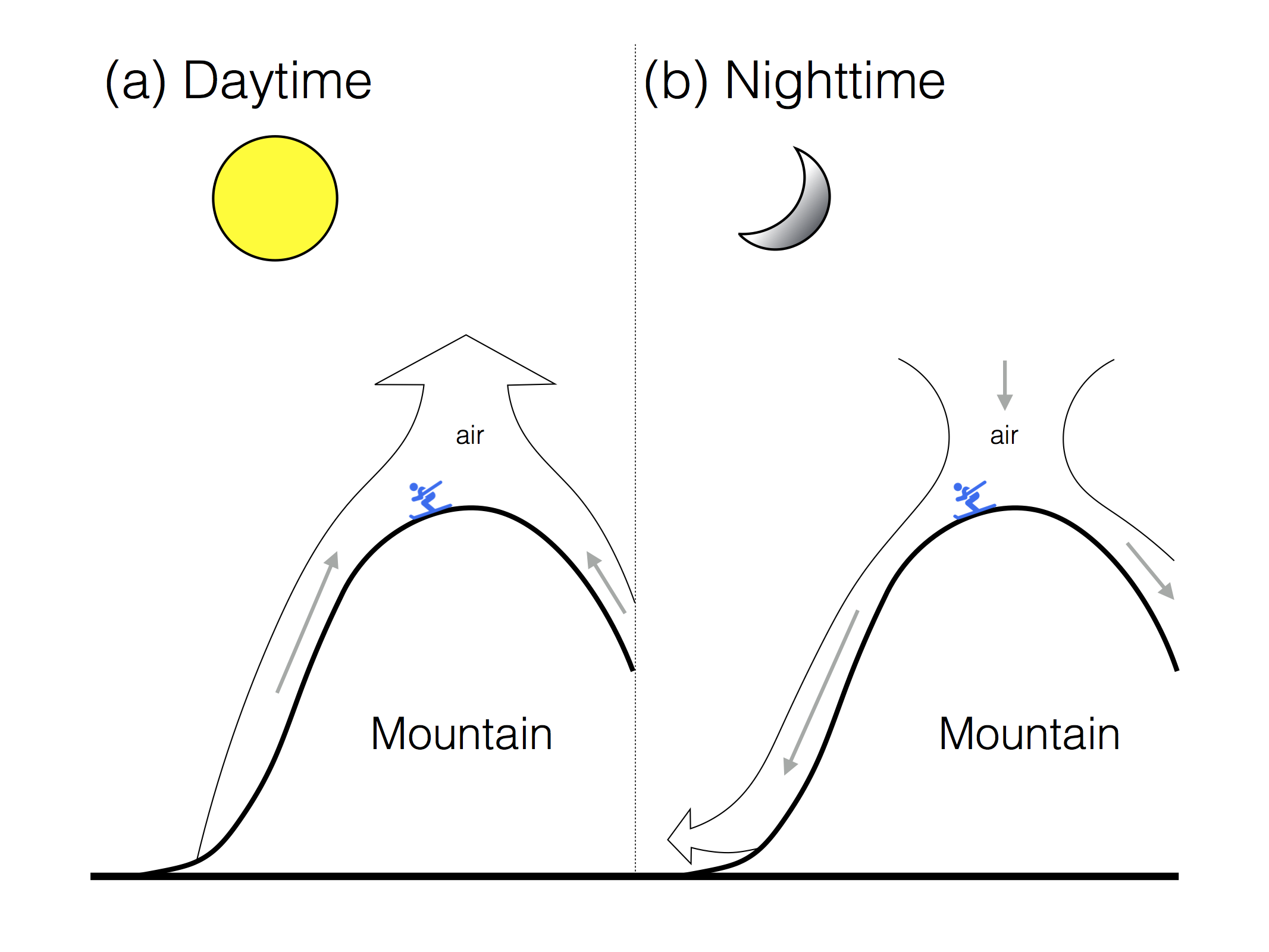
Fig. 6b.1 Diurnal slope flows in the (a) daytime, when warm air ascends the mountainside and rises vertically at the mountaintop, and (b) nighttime, when cold air drains down the mountainside, leading to cold air pooling in the valley. (Credit: Howard, inspired by Stull. Skier icon, not to scale, made by Freepik from www.flaticon.com).
Daytime slope flows
During the day, the incoming shortwave radiation (sunlight) from the sun heats up the ground surface. This is called radiative heating . The ground then heats the air just above the surface. The warm air rises and travels up the mountainside (as opposed to rising vertically). This upslope thermally-induced motion is called an upslope flow , or anabatic wind (Fig. 6b.1a).
Anabatic wind speeds are usually around 10-20 km/h, and the depth of the rising layer can be hundreds of metres. As the warm air reaches the ridgetop or mountaintop it rises vertically, often combined with the air from the next valley over. If there is enough moisture present, cumulus clouds (called anabatic cumulus clouds) can form over the mountaintop (Fig. 6b.2). In the summer, if these updrafts are strong enough, showers and thunderstorms can form. This is not a concern for skiers except maybe in late spring, when solar heating is stronger.
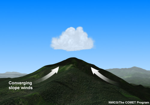
Fig. 6b.2 Anabatic cumulus cloud over the top of a mountain ridge due to upslope, or anabatic winds (Credit: COMET/UCAR).
When the sunshine is strong and sustained, for example over the course of a whole afternoon or day, a return flow can form in the valley. As the rising air ascends the mountainside, air must descend from aloft (directly above the valley floor) to replace the heated air leaving the valley bottom. In turn, the heated air that has ascended the slope and risen above the mountaintop moves towards the centre of the valley above the valley floor, to replace the air that has descended. This "recycled" air then descends to replace the next cycle of air that is rising up the mountainside due to the heating from the sun. As the recycled air descends, it warms, meaning it can ultimately be warmer than the next cycle of air, since it has already undergone one (or more) cycles of heating by both (a) the mountainside and (b) descending over the centre of the valley. In reality the individual "cycles" of air discussed are all joined together with no gaps, and the process is continuous.
As a skier or snowboarder, you should not be concerned about anabatic winds producing hazardous wind speeds. However, you should be aware of the warmer temperatures it can bring to the mountain slopes, on top of the regular daytime heating, in fair weather. It can also help to dissipate valley fog/cloud, and cold pools/inversions, as we talk about in Learning Goals 6a, 6c, and 6d.
How does the land surface itself affect this heating from the sun?
Snow cover reduces the amount the air is heated by the ground surface, since most of the sunlight is reflected by the snow. The amount reflected depends on how old, dry, and dirty the snow is. Generally speaking, new, dry, pristine snow reflects the most sunlight at around 95%, and old, wet, dirty or contaminated snow reflects the least, as low as 35%. The remaining sunlight is absorbed by the snowpack and usually goes into either warming the snow, or melting it.
In the absence of snow on the ground, the ground absorbs about 10% of incoming shortwave radiation. And even if there is snow on the ground inhibiting the heating, the dark trees, rocks and any vegetation that is exposed can get hot during the day by absorbing heat from the sun directly; they can get much warmer than 0°C (and they don't melt!). In this scenario, air temperatures might get warmer than expected (recall that when the ground warms, it also warms the air above it). Lower elevations in particular may have little to no snow.
Nighttime slope flows
Learning Goal 6a on cold air pooling explains how thermally-driven downslope winds, or katabatic winds, develop at nighttime when there is a high pressure system. Recall that once the sun sets and the ground is in the shade, the ground is no longer being heated by the sun. Instead, it cools, losing energy by radiative cooling . In turn, the air next to the ground surface also cools down. This colder, denser air drains down the mountainside into the valley, due to gravity (Fig. 6b.1b).
Katabatic wind speeds reach 10 to 30 km/h and typical depths of the sinking layer are 10 to 100 metres. They are shallower than anabatic winds, mainly because there is less turbulence and upward motion. As the shallow layer of cold air moves downslope, it converges into small valleys and gullies. The air in these gullies converge into larger river valleys, and eventually into a valley cold pool of air (Learning Goal 6a).
Try to visualize what would happen if you were to slowly pour a huge amount of water evenly over a mountaintop with valleys surrounding it. The water would flow downhill draining first through the smaller mountainside gullies then into the wider valleys. Air is a fluid just like water, but water is more dense (essentially heavier for the same volume), so sinks beneath the air. Now, for our nighttime katabatic flow, imagine the water and air in the scenario just described are cold air and warm air, respectively. The effect is not as pronounced as you may have visualized, since the density difference between cold and warm air is much less than the density difference between water and air. However, the physics is the same.
One of the main concerns with katabatic winds for skiers is the cold temperatures in these drainage flows. These can make your first and last ski runs of the day pretty cold. Also, the resulting cold air pooling in valley bottoms (Learning Goal 6a) and valley cloud/fog formation present additional concerns (Learning Goal 6d).
Keywords:
diurnal slope flow, thermal, radiative
heating, upslope flow, anabatic wind, anabatic cumulus clouds, return
flow, radiative cooling, katabatic wind, cold pool
Figure Credits: Howard: Rosie Howard, West: Greg West, Stull: Roland Stull