ATSC 113 Weather for Sailing, Flying & Snow Sports
Temperature Inversions
Learning Goal 6c: Explain what a temperature inversion is and why it is important to mountain recreation
In Flying Module Learning Goal 3a you were taught that temperature generally decreases with height in the troposphere (Fig. 6c.1). However, occasionally temperature can increase with height for some layer of air in the troposphere. This is known as a temperature inversion .
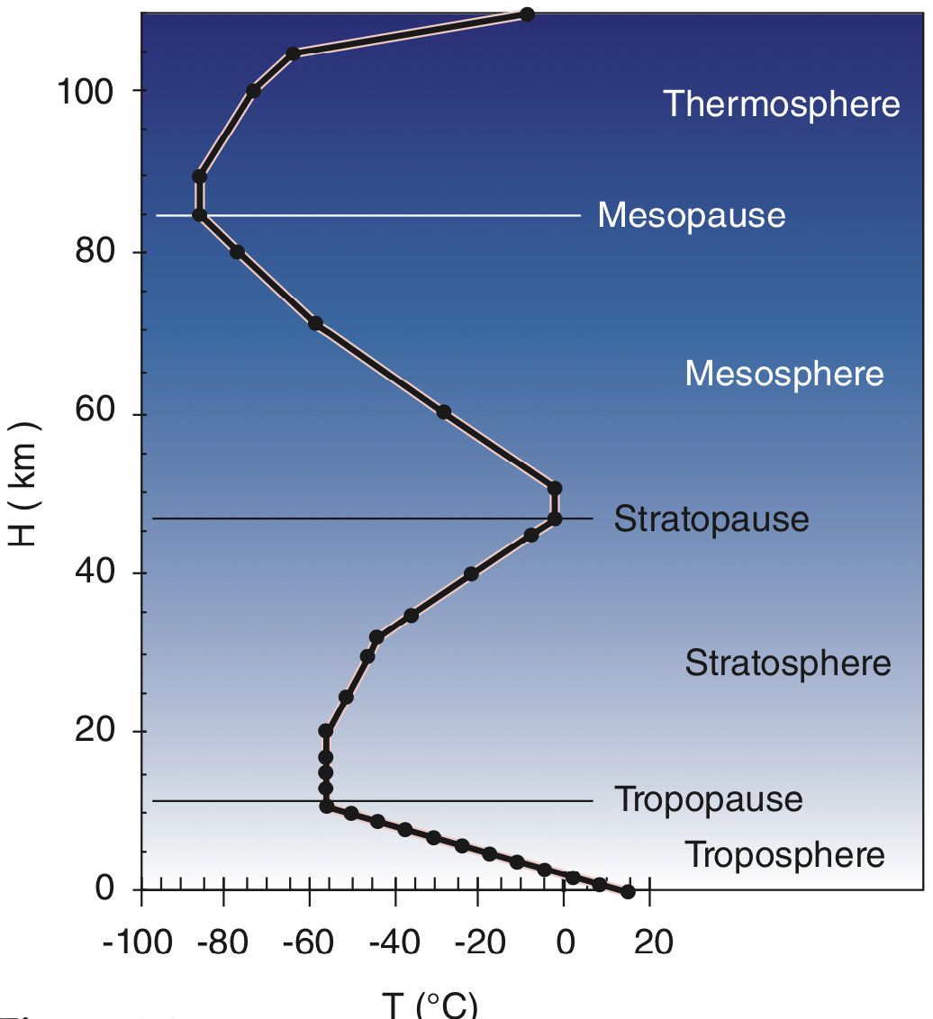
Fig. 6c.1 Temperature variation with height according to the Standard Atmosphere. (Credit: Stull).
Cold air is more dense (heavier for the same volume) than warm air. If a layer of cool air lies beneath a layer of warmer air, then those layers are statically stable , and there is little or no vertical motion, because the heavier layer is already at the bottom. So when there is an inversion, and temperature increases with height (cold air under warm air), the atmosphere is very stable. Due to the adiabatic lapse rate , even if the temperature decreases slowly with height, i.e. the air near the surface is very slightly warmer than air above it, it's also considered stable, though not as stable as when there is an inversion.
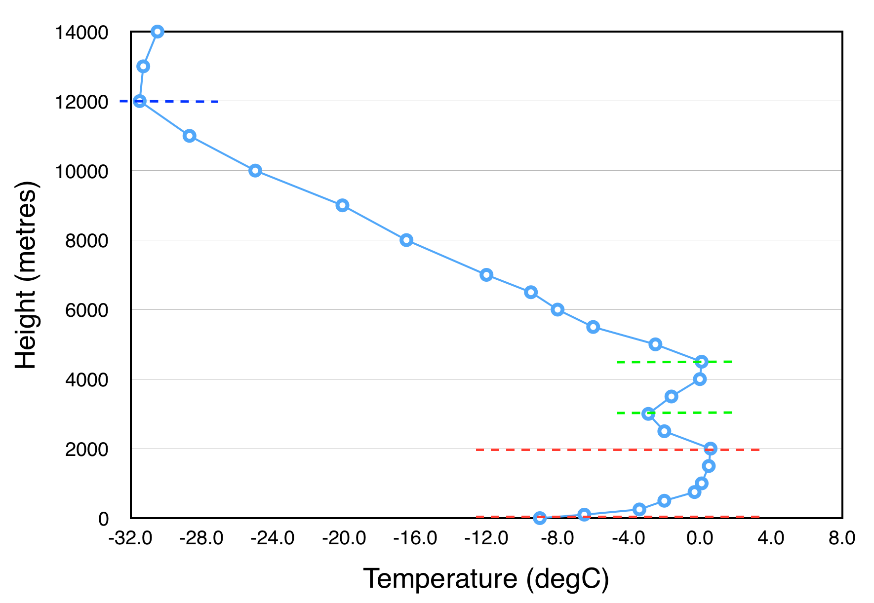
Fig. 6c.2 Example of a vertical temperature profile with a deep inversion at the ground surface at 0-2000 metres (between red dashed lines), a second inversion at 3000-4500 metres (between green dashed lines), and the usual inversion found as we head from the troposphere into the stratosphere (above the dark blue dashed line). The light blue line joins temperature measurements (blue circles) throughout the troposphere. (Credit: Howard).
In snow sports, it is important to know the conditions under which an inversion may be present; otherwise, you would experience unexpected temperature changes up and down the mountain. That is, when there is an inversion, you will find warmer temperatures at the middle-to-top of the mountain and colder temperatures in the valley. This affects the gear you choose to wear. It also affects the snowpack, leading to cold processes in valley locations, e.g. surface hoar formation (Learning Goal 7i), and at upper elevations the warmer temperatures can cause melting, potentially even contributing to wet-type avalanches (Learning Goal 7j).
In mountain valleys, an inversion can trap moisture within the valley (since stable air resists vertical motion), leading to valley cloud and fog formation (Learning Goal 6d). Pollution from cars and industry can also get trapped, sometimes for days or even weeks! If pollution and moisture both get trapped under an inversion, it can lead to a situation like the one in Fig. 6c.3. Usually, pollution is not an issue for skiers in mountain valleys in the winter, but the picture helps you to see how strong the effect of an inversion can be.
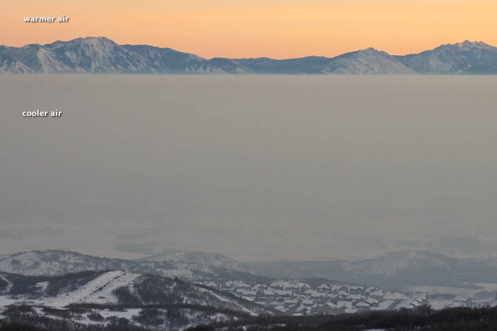
Fig. 6c.3 Pollution and moisture trapped under an inversion layer combine to form a thick haze within the Salt Lake Valley. (Credit: NASA)
Inversions do not only happen in the air just above the surface. Since stable air resists vertical motion, if a temperature inversion occurs anywhere else within the troposphere (e.g. dashed green lines in Fig. 6c.2), it behaves like a lid or cap, trapping the air below. Generally speaking, air rising from below does not travel any higher than the inversion layer. You may hear this referred to as a capping inversion .
How do inversions occur?
The processes that make inversions relevant to snow sports are:
-
Subsidence due to high pressure
Recall from Learning Goals 5e and 5i that high pressure systems are associated with large-scale subsidence or sinking motion. As the air descends, it warms (at the dry adiabatic lapse rate) and becomes drier. When the high pressure system is strong and sustained over time, that descending air layer may become warmer than the layers below it, e.g. those within a mountain valley. This sets up a warm layer over cold layer, or an inversion. In winter in particular, other processes (see below) may reinforce the cold air within the valley.
-
Radiative cooling of the ground
On clear calm nights, the Earth's surface radiates heat into space. Since there is no heat from the sun during nighttime to counteract this heat loss, the ground cools. The air in contact with the surface also cools down over time. This leads to (or strengthens) an inversion at the ground like the one shown between the red dashed lines in the temperature profile in Fig. 6c.2.
In winter in the mountains there is often snow on the ground, which amplifies the effect. The surface is already at or below 0°C, and the snow surface loses heat even more quickly than bare ground.
In addition, during the daytime in the winter, the sun angle is low (Learning goal 6i). This reduces incoming solar energy, and in turn, the heating of the ground/snow surface, compared with other times of the year. This means that the surface and air just above it does not ever get very warm (like it would in the summer, for example). Also, snow reflects most of the incoming radiation from the sun during the day. Valley cloud and fog can reduce incoming solar radiation further. The end result is that wintertime inversions in mountain valleys can be sustained for weeks on end under persistent high pressure.
It is common for the processes described above to interact, with radiative cooling at and just above the surface, and warming of the atmosphere aloft due to subsidence above. This leads to a very pronouced, very stable temperature inversion.
Keywords: temperature inversion, statically stable, adiabatic lapse rate, valley cloud and fog, capping inversion, subsidence
Figure Credits: Howard: Rosie Howard, West: Greg West, Stull: Roland Stull