ATSC 113 Weather for Sailing, Flying & Snow Sports
Wind-Exposed Locations
Learning Goal 6f: Identify and explain areas in the mountains that are likely to be wind-exposed.
What is a wind-exposed location and why is it more windy there?
Over flat land, friction slows down the wind at the ground surface, so you experience slower wind speeds than higher up in the free atmosphere. Typical wind-exposed locations include mountain peaks and ridgetops. At these elevations there is hardly any upstream (the direction the wind is coming from) landmass or ground to slow down the wind by friction. Essentially, fast winds from higher up in the troposphere hit the mountain peaks and ridgetops head on.
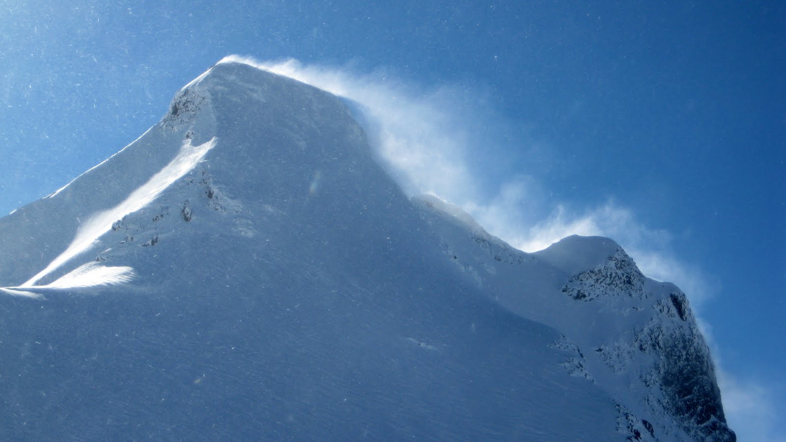
Fig 6f.1 - The exposed peak of Mount Matier is one of the highest in the Duffey Lake region of BC. The photographer is standing in a less exposed location, and you can see that the peak is significantly windier due to blowing snow. (Credit: West.)
If you're on a ridge within a mountain range with many other ridges and peaks at similar heights, the friction and turbulence induced by the surrounding ridges will slow down the winds somewhat. That being said, do not underestimate ridgetop wind speeds. They are usually much stronger than wind speeds not too far below.
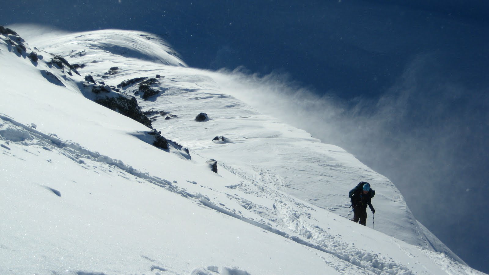
Fig. 6f.2 - Windy ridgetop conditions in the Duffey Lake region of BC. Ridgetop winds and blowing snow usually leads to cornice formation (snow that overhangs on ridgelines). This can present a fall hazard if a skier is traversing on top of it and it breaks off. Also, it can be an overhead hazard for skiers below. If it breaks, not only could it hurt skiers directly, but it could cause an avalanche. (Credit: West.)
The most extreme examples of wind-exposed locations are isolated volcanic peaks, because they can rise so far above surrounding terrain (Fig. 6f.3).
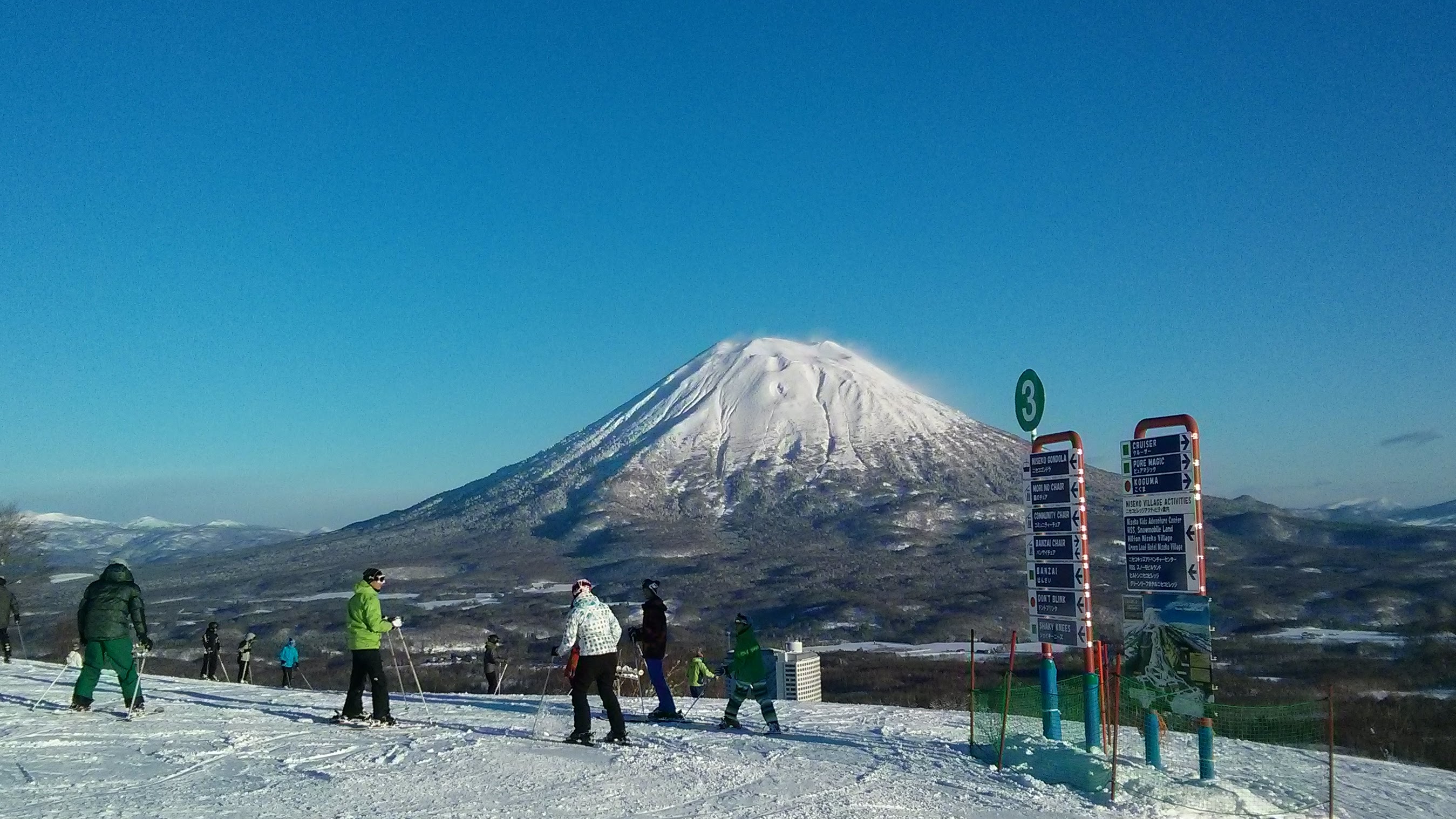
Fig. 6f.3 - Volcanos often rise far above surrounding terrain. Here, some spindrift, or snow blowing off the peak, can be seen on Mount Yotei-san in Niseko, Japan. The skiers in the foreground at lower elevations on a nearby mountain are enjoying a sunny day with calm winds. (Credit: West.)
The Venturi or Bernoulli Effect
A second reason that winds can be stronger on ridges and mountain tops is something known as the Venturi or Bernoulli effect. Under certain atmospheric conditions, the flow may become more constricted as it flows over a ridge or peak (Fig. 6f.4). This convergence of wind into a constricted area behind the mountain accelerates the flow over the ridge or peak. Picture the grey area to the left of the mountain (on the windward side) as water. In this scenario, for all the water to flow into the grey region on the right side of the mountain (the leeward side), it must speed up.
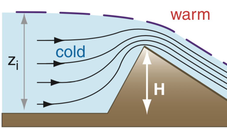
Fig. 6f.4 - Air converging into a constricted area over a mountain barrier, accelerating the flow over the peak/ridge. (Credit: Stull.)
Other wind-exposed locations
Winds on slopes and within valleys are only loosely related to the speeds indicated on pressure-level maps because they are relatively sheltered by the higher surrounding ridgelines. If wind speeds are shown as strong on pressure-level maps, winds that travel down slopes off a ridge at that pressure-level will likely be weaker than those at ridgetop. However, they may still be moderate to strong or gusty in alpine or other treeless areas.
High wind speed hazards
Research shows that in real life people almost always overestimate wind speeds. They might say, "It was super windy on Whistler Peak chair yesterday! 80 km/h for sure!", when in reality, the wind speed was probably 40 km/h. A sustained wind of 40 km/h is very unpleasant to be out in, and will cause significant snow transport. (The threshold at which dry powdery snow starts to get picked up and moved by the wind is just 14 km/h.)
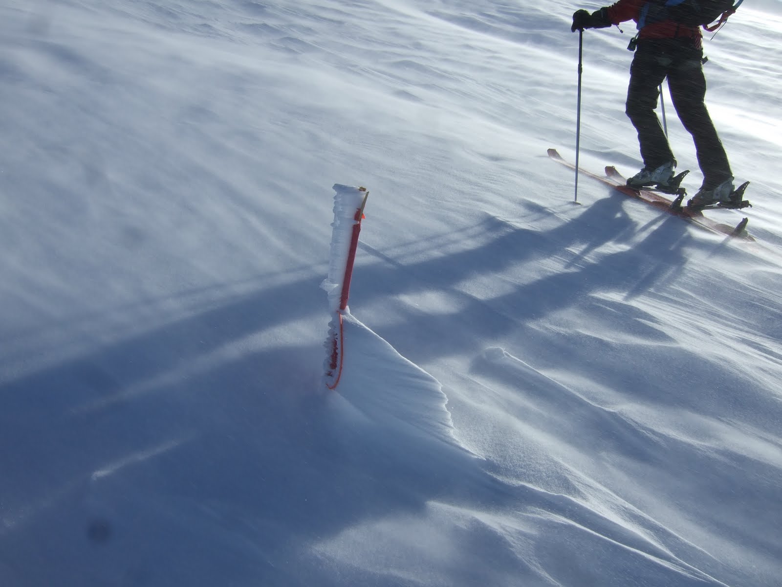
Fig 6f.5 - Drifting snow on Mount Hood, OR, USA. (Credit: West.)
At 75 km/h, you can lean into the wind at a 45°-angle and it will support you (Fig. 6f.6)!
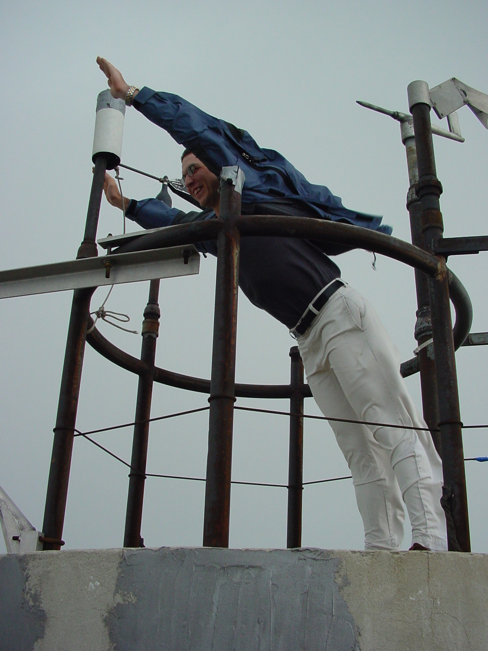
Fig. 6f.6 - A weather observer leans into 75km/h winds on Mount Washington, NH, USA. (Credit: West)
At 200 km/h, it's extremely difficult to stand or walk at all. The wind can knock you off your feet, and even toss you downwind! These are extremely dangerous conditions where movement is not feasible, tents will likely be destroyed, and in cold temperatures frostbite is almost instant.
Here's a quick video showing what winds of 160-220 km/h look like, and and here is another (Mount Washington, NH, USA).
Story Time
I spent a couple of summers working at the mountaintop weather observatory on Mount Washington, NH, USA. It's a fairly unassuming mountain by global standards, peaking at just under 2000 m (6288 ft). However, it's famous for having some of the "world's worst weather" due to it being the highest peak in the northeast US, and higher than any other peaks in eastern Canada for that matter. It is also at the confluence of multiple storm tracks.
Anyway, the story goes that after the Everest IMAX movie was filmed, they needed some additional filler footage of climbers hiking in stormy weather. They brought a climber from the Everest expedition to Mount Washington during some predicted stormy weather. She was reportedly complaining about having to waste her time on this "piddly hill". In the end, conditions got so bad on this "piddly hill" that she became hypothermic and had to be rescued off the mountain. This serves as an important reminder that no matter the size of the mountain, bad weather is bad weather, and it can be dangerous any time you're not properly equipped.
It is possible, although difficult and unpleasant, to travel in high wind speeds. If you're properly dressed or have sufficient shelter, it can be done without any direct consequences. However, wind can quickly compound the danger of a situation if something else goes wrong.
For example, your party may be properly dressed for actively skiing in windy, cold conditions. However, if someone fell and broke their leg, for example, you may not be dressed warmly enough to avoid hypothermia while sitting still, tending to the person, or awaiting rescue. Winds may also prevent rescue personnel from getting to you.
A further hazard that the wind presents is wind chill, where the wind causes you to feel colder than the actual air temperature (see Learning Goal 5g).
Key words: Venturi effect, Bernoulli effect, wind chill
Figure Credits: Howard: Rosie Howard, West: Greg West, Stull: Roland Stull
COMET/UCAR: The source of this material is
the COMET® Website at http://meted.ucar.edu/ of the University
Corporation
for Atmospheric Research (UCAR), sponsored in part through cooperative
agreement(s) with the National Oceanic and Atmospheric Administration
(NOAA), U.S. Department of Commerce (DOC). ©1997-2016 University
Corporation for Atmospheric Research. All Rights Reserved.
NOAA: Images courtesy of National Oceanic and
Atmospheric Administration/Department of Commerce, www.noaa.gov
NASA: Images courtesy of National Aeronautics and
Space Administration, www.nasa.gov
Google: Map data (c) 2016 Google.
Libbrecht: Kenneth Libbrecht, SnowCrystals.com Garrett:
Professor Tim Garrett, University of Utah