ATSC 113 Weather for Sailing, Flying & Snow Sports
Surface Heating and Cooling
Learning goal 6i: List and explain factors affecting heating/cooling at the surface, and adjust your temperature forecast accordingly.
Temperature forecasting can be thought of as a two-step process. First, obtain the temperature at your location from a pressure-level map at an elevation close to the one you are concerned with, and vertically interpolate the temperature to your elevation (Learning Goal 6h). Second, adjust that temperature based on the heating or cooling that may be occurring at the surface.
The vertical interpolation process in step one gives you the free-air temperature, or the temperature at that elevation in the absence of heating or cooling from the surface. We will learn the second step in this learning goal.
Surface heating or cooling adjustments
Within the troposphere, the initial source of heating and cooling is the ground surface. During daylight hours, the ground surface is heated by the sun, which in turn heats the air next to the surface. Other processes transfer this heat upward into the troposphere. At nighttime, especially when there are clear skies, the surface cools radiatively (loses heat energy). Often, the largest amount of cooling is observed right at the ground surface. Thus, in the nighttime and early morning hours, the coldest air is usually found right near the ground surface.
There are several factors that affect heating and cooling:
-
Sun angle
Sun angle is the angle at which the sun's rays strike the earth's surface. Not only does this vary on a daily basis, but have you noticed that the sun is higher in the sky at noon in June than at noon in January?
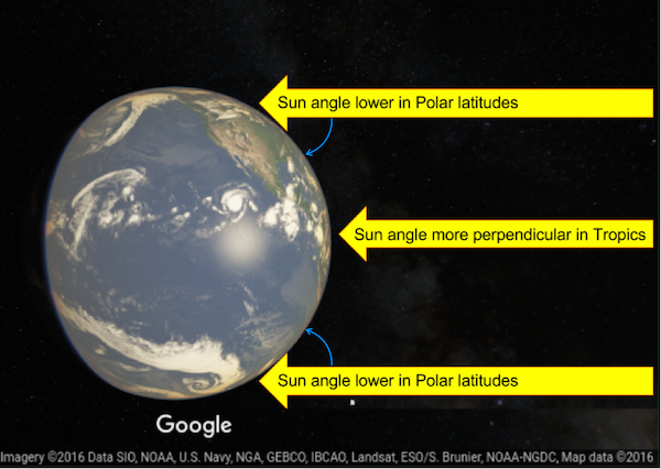
Fig. 6i.1 - The sun's radiation intersects the equator and the tropical latitudes of the earth at a relatively perpendicular angle (90°). The perpendicular angle means the heating energy is most concentrated here which is why these latitudes are the warmest. In the mid- and polar-latitudes, the sun's radiation intersects the earth at a lower angle. Note that the angle, indicated by the blue arrows, made between the sun's rays and the earth's surface is less than 90°. This means the same amount of radiation is spread over a larger area, so the middle and polar latitudes receive less heating. The polar regions receive the least, hence why they are the coldest places on earth, on average. (Credit: Google/West)
Sun angle varies by season due to the tilting of the earth on its axis. This controls the rate at which the sun heats the ground. The midlatitudes are tilted away from the sun in winter (in both hemispheres), so sun angle is low, and heating from the sun is much weaker. The minimum sun angle occurs on December 21st, the winter solstice. In the spring the sun angle increases, reaching a maximum on the summer solstice, June 21st.
It's important to note that the number of daylight (and heating) hours is much less in winter than in spring. So, in the winter, the sun heats the earth for fewer hours, and at a lower intensity. In the spring, not only are there more hours of heating, but the heating intensity is greater. The end result is that in winter, the heating adjustment (to the free-air temperature) for the daytime high temperature is small (0-3°C). In the spring it can be much larger (4-10°C). See Table 6i.1 for a summary of the temperature adjustment rules of thumb discussed in this section.
At night, sun angle is not a factor since there is no solar radiation reaching the earth's surface (at your location).
-
Cloud cover
On sunny (or mostly sunny) days, the unshaded ground surface receives the maximum (or close to maximum) possible incoming solar radiation. Therefore the heating adjustment for the daytime high temperature is maximised (Table 6i.1). Cloud cover reduces the amount of incoming solar radiation that reaches the ground (where it would in turn heat the air). This reduces the daytime heating adjustment.
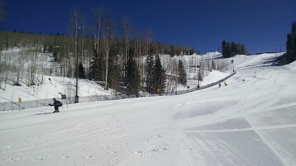
Fig. 6i.2 - Sunny conditions on the race course in Telluride, CO, USA. Under clear skies we see maximum daytime heating and nighttime cooling. (Credit: West)
With overcast conditions (solid cloud cover), hardly any of the sun's energy reaches the ground, so heating is greatly reduced. Under partly cloudy skies, a very rough estimate is that about half the sun's energy makes it to the surface. The actual amount depends upon the fraction of cloud cover and the heights of those clouds, and can vary greatly.
At night, the sun is no longer a source of energy. If there is no cloud cover, the ground loses heat energy to space. If there is cloud cover, the energy from the ground is absorbed by the clouds, and re-radiated back towards earth, so the surface does not cool as much as it would under clear skies. This is especially true for completely overcast situations. Thus for cloudy nights, the surface cooling adjustment is small (a few degrees), whereas for clear nights, it can be as large as 10°C.
-
Wind Speed
During the day the wind can reduce the solar radiative heating effect to some extent. Flying Module Learning Goals 3c and 3f mention that turbulence can be produced by wind shear (different wind speeds or directions at different altitudes), creating mechanical mixing. This turbulence or mixing brings cooler air from just above the surface above down closer to the surface, so that the mountain slope-air temperature is closer to the free-air temperature (Table 6i.1). The higher the wind speed, the greater the effect.
At night, wind shear turbulence mixes warmer air from above down close to the surface, reducing the radiative cooling effect. This again means that the mountain slope air is closer to the free-air temperature. Calm winds allow for the most radiative cooling to take place.
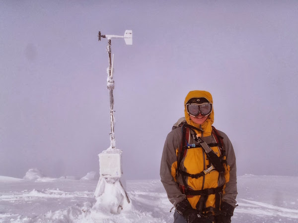
Fig. 6i.3 - Cloudy and windy conditions limit daytime heating, and also limit the amount of cooling that takes place overnight. Mount Niseko-Annapuri, Japan. (Credit: West)
These effects are summarised in Table 6i.1 for forecasting the daytime high (afternoon maximum) temperature and the early morning low (morning minimum) temperature. Note that the coldest temperature each day usually occurs right before sunrise. The precise adjustment numbers vary by the specific weather, terrain, latitude, etc., but these are useful as rough guidelines. You should add or subtract these values from your free-air temperature obtained in the first step, and then fine tune them based on experience as you build it.
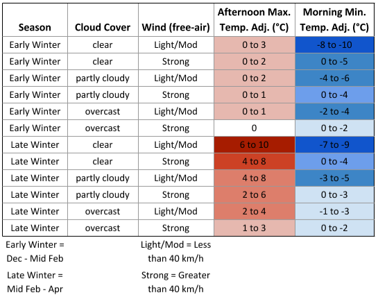
Table 6i.1 - Mountain temperature forecast adjustment look-up table for various weather conditions. Colours indicate the amount of positive (red) or negative (blue) temperature adjustment, with darker shades indicating a larger adjustment. For free-air wind speeds, "Light/mod" is less than 40 km/h, and "Strong" is greater than 40 km/h. (Credit: West)
Keywords: free-air temperature
Figure Credits
Howard: Rosie Howard
West: Greg West
Stull: Roland Stull