ATSC113 Weather for Sailing, Flying & Snow Sports
Terrain Channelling of Winds
Learning Goal 6m: Describe and explain terrain channelling of winds and why this affects skiing
Modification to large-scale winds
Large-scale winds are usually modified in some way by terrain features. The wind can accelerate when it passes over ridgetops, and get channelled through valleys and gaps in terrain. This channelling can modify the wind direction substantially, almost always in the along-valley direction. Which direction (up- or down-valley) usually depends upon the larger-scale pressure pattern. This was discussed briefly in Learning Goal 6l.
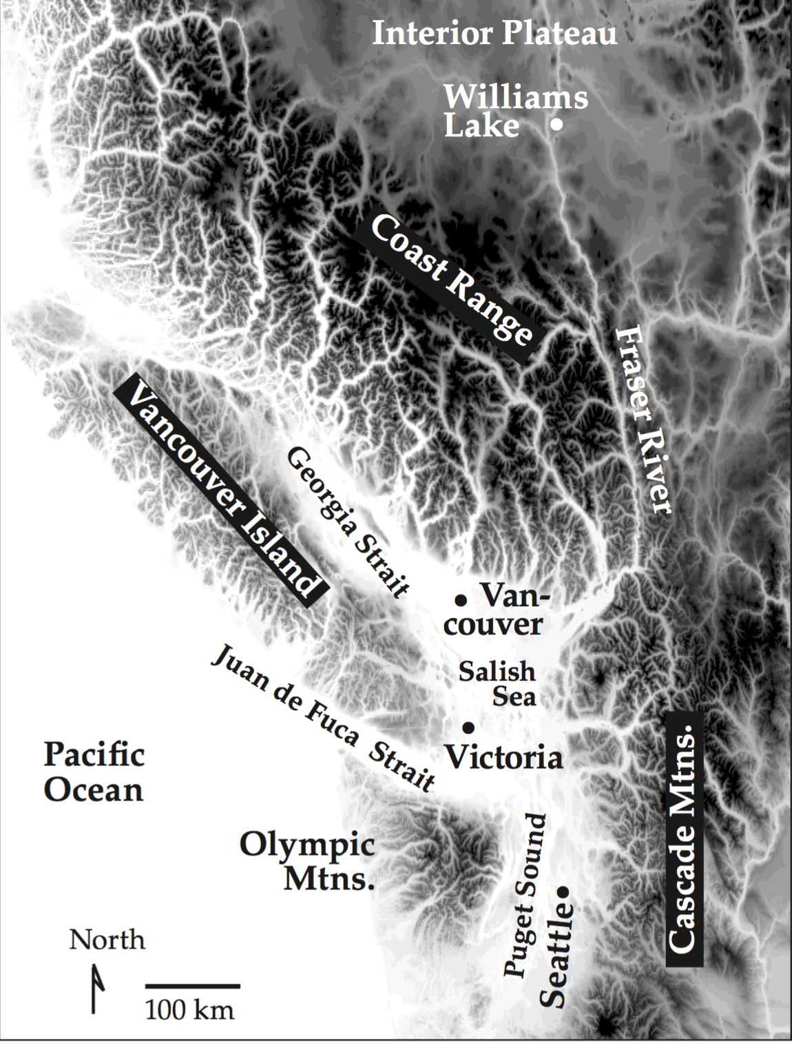
Fig. 6m.1 shows how complex the terrain is along the southern BC and Washington coast, and some of the interior.
Gap winds
Gap winds usually occur when the large-scale prevailing wind direction is perpendicular to the large mountain range. This makes the phenomenon a fairly frequent occurrence for the BC Coast Mountains , which runs southeast to northwest. The most common weather pattern is when cold, Arctic air approaches the Coast Mountains from northeast. Since it is much more dense than the overlying warm air, the BC mountain range acts as a barrier, damming the stable, cold air behind it.
However, there are topographical gaps such as river valleys and mountain passes that the cold air can more easily move through. As it does this, conservation of air mass requires that it accelerates. Therefore, we see faster winds in the narrow valleys. Wind speeds of 20-90 km/h have been observed for gap winds.
Since the Arctic airmass dammed behind the mountains is associated with high pressure, there is a pressure gradient (a change of pressure across a horizontal distance) across the mountain range when there is a region of low pressure just to the west or southwest of BC over the Pacific Ocean. This pressure gradient drives the gap wind (since air flows from high to low pressure). At the BC coast, the strong gap winds are propelled out of the gaps as the valleys and inlets get wider towards the ocean as the cold, dense air spreads out radially. This is similar to knocking over a glass of water and watching it spread across the table, rapidly accelerating out of the glass as it first spreads out.
Here is some NWP output of 10-m (surface) winds showing gap winds developing later in the loop, beginning at approximately noon (PDT) on Saturday 15 October. Click on the button below for the full loop. A still frames is given below as well (Fig. 6m.2).
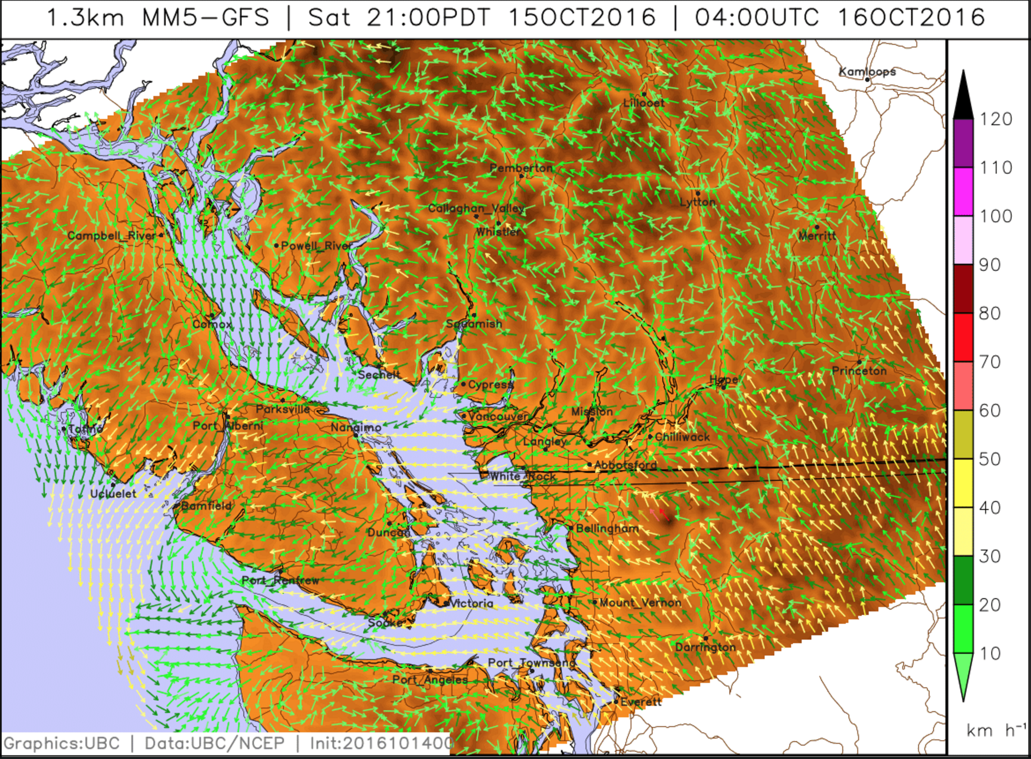
Skiers should take note of when an event like this occurs, since it brings faster winds and usually colder temperatures, resulting in the need to dress more warmly (or consider not skiing at all if it's cold enough), and modifies the wind direction and determining which slopes are wind-affected and wind-sheltered.
Keywords: along-valley, gap winds, conservation of air mass, pressure gradient
Figure Credits: Stull: Roland Stull, West: Greg West, Howard: Rosie Howard