ATSC 113 Weather for Sailing, Flying & Snow Sports
Density of Newly-Fallen Snow
Learning Goal 7b: Define snow density and describe what conditions will lead to high vs. low density newly-fallen snow, and why this matters to skiers.
What is snow density?
Snow density can be defined as the amount or mass of ice and liquid water per volume. You shouldn't worry too much about the liquid water part because there is usually a LOT more ice than liquid water in the snowpack. However, in the spring, liquid water content can be more significant. Snow density measurements are usually not divided into ice and liquid water components though, and it is the total (= frozen water + liquid water) density that we are concerned with here anyway.
Fig. 7b.1 gives you a reminder of the range of snow densities you will find in a snowpack, although note that the characteristics here are not constrained to newly-fallen snow. Newly-fallen snow is generally in the 30-300 kg/m3 range.
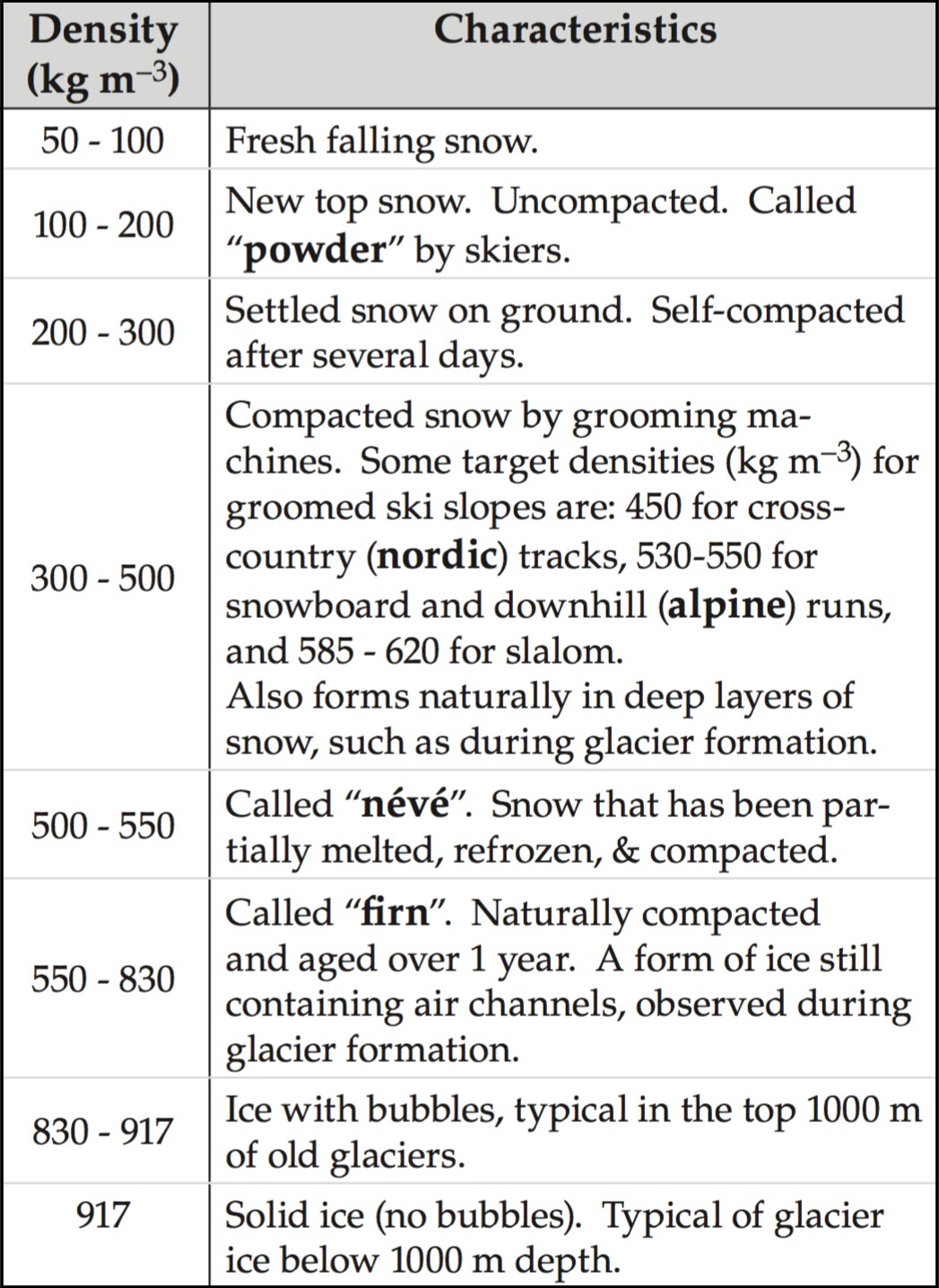
Table 7b.1 - Typical snow densities ranging from freshly fallen snow (lowest) to solid ice (highest). (Credit: Stull)
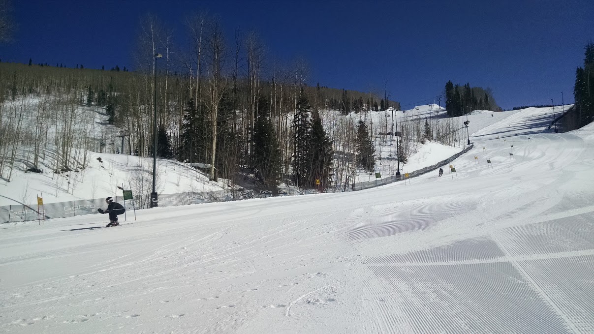
Fig. 7b.1 - This newly-compacted snow on this recreational race course is probably around 350 kg/m3. Telluride, Colorado, USA. (Credit: West)
The effect of conditions on newly-fallen snow
-
Temperature
Generally, the warmer the temperature, the higher the density of newly-fallen snow. For temperatures close to freezing, you can expect higher density snow, partially because it has higher water content too (water is more dense than ice, which is why ice cubes float in water). To think of it the other way, the lower the temperature, the lower the density of newly-fallen snow. This relationship holds down to about -15°C. At temperatures colder than that, density doesn't change much.
-
Wind
Similarly, with faster wind speeds, one can generally expect higher-density newly-fallen snow. With slower winds speeds, one can generally expect lower-density newly-fallen snow. The relationship between wind speed and snow density is weaker than that between temperature and snow density. For higher wind speeds around 15 m/s and above, you're likely to encounter high-density snow. For low wind speeds, you might get low density snow, but it's also possible to get high densities (e.g., if temperatures are warm).
In summary, higher density newly-fallen snow comes with warmer temperatures and faster wind speeds. Lower density newly-fallen snow comes with colder temperatures and slower wind speeds.
Snow density and ski quality
In skiing and avalanche science, a popular convention is to represent snow density by its percentage of water and ice content, called total water content. (Note: this assumes that the densities of ice and liquid water are equal, which is not true, but they are close enough) To convert from density in terms of kg/m3 to %-water content, just divide by 10 and add a percent sign. Therefore, according to the above Table 7b.1, freshly-fallen and new snow typically range from 5-20%.
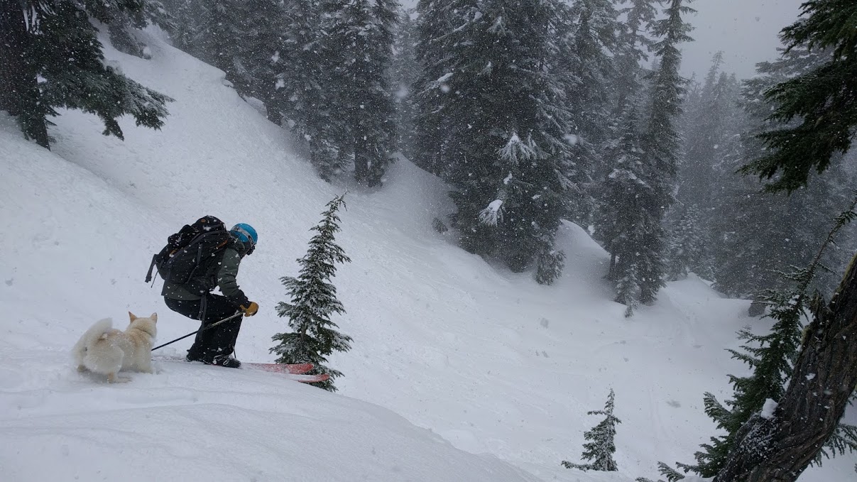
Fig. 7b.2 - High-density newly-fallen snow at Steven's Pass in the Cascade Mountains of Washington, USA. (Credit: West)
In general, low- to medium-density (light) snow is more enjoyable to ski in than high-density (heavy) snow. The lighter, fluffier snow is easier to push around with your skis, while heavier snow tends to take more effort to muscle through. Lighter snow also tends to spray or billow up into the air more as you ride through it, which adds to the powder skiing sensation/enjoyment ...and equally important, looks better in photos and video.
Newly-fallen snow that's about 7% total water content or less would be considered light, low-density snow, and the average is about 8-11%. Snow that is 11% or more is considered heavy snow. If you look at the average snow density across North America (in and out of the mountains), it's about 8%. Remember that this all refers to newly-fallen snow, before it has settled (or been compacted like in a ski resort).
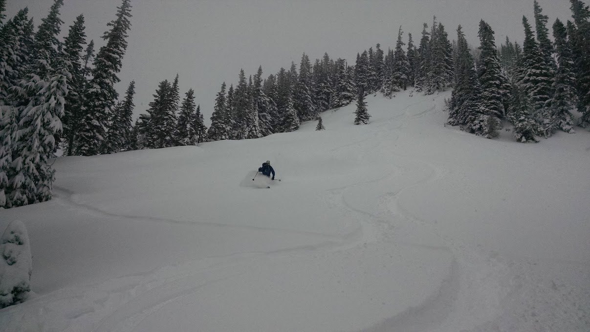
Fig. 7b.3 - A skier on Yak Peak in BC finds some very nice low-medium density powder (likely 7-8%). (Credit: West)
Powder snow is generally considered to be unconsolidated (not packed) snow that is low to medium density. In powder snow, when you gain enough speed your skis/board start to "float" on the snow (similar to a waterskier or surfer). The rider can then weight and unweight their skis/board from turn to turn, which gives a nice floating-bouncing sensation. This, combined with snow spraying up in your face, is the ultimate goal of powder seekers. In fact, skis have become much wider over the past 15 years with the goal of making it easier for skiers to float in powder.
The optimum snow density for powder skiing is actually not the lightest snow possible, but rather snow that's around 8% total water content. This medium-density snow is still easy to ski and light to push around/through, but has enough "body" to provide flotation. In very low-density snow (~5%) skis/boards have more of tendency to push through the snow instead of floating on top of it. This is typical of the Rockies' snow climate which features relatively small new snow accumulations with cold temperatures, resulting in small amounts of low density snow. These conditions may make for good photos with snow billowing up around you, but your skis/board will mostly be just riding on whatever snow surface is underneath the newly fallen snow.
In Learning Goal 7c we'll take things a step further, looking at how density changes within newly fallen snow affect skiing/riding quality.
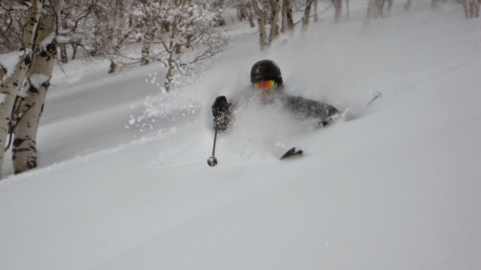
Fig. 7b.4 - A skier gets deep into some low-density powder in Big Cottonwood Canyon, Utah, USA. This snow is likely 5-7% total water content. (Credit: West)
Density and avalanche danger
Snow density is an indication of the strength of the snowpack. In general, the more dense the snow, the stronger the bonding between crystals. In newly-fallen snow, the crystals are usually still in a stellar-type form. Avalanche problems within newly-fallen snow are often the result of density changes during a storm. We'll talk about this more in Learning Goal 7c. Bonding between crystals in newly-fallen snow is not as strong as that between rounds, no matter what temperature it falls at.
One exception to this is when snow is falling during strong winds. When this occurs, crystals collide violently in the air, and get blown across the ground, breaking off the crystal arms. When they settle on the ground they can become further packed by the wind. The resulting newly-fallen snow can be very dense and well-bonded. This is called wind board or a wind slab.
Fig. 7b.5 - Wind-packed snow on Mount Hood, Oregon, USA. This would be considered wind board or wind slab. The weird texture and ridges of the wind-affected surface is called sastrugi. (Credit: West)
As we discuss in Learning Goal 7f, an unstable snowpack typically results from denser layers overlying less-dense layers. Thus if you have relatively high density newly-fallen snow (resulting from warm temperatures or wind) that has fallen on top of a faceted layer, this can result in an unstable, dangerous snowpack. Likewise, even low-medium density newly-fallen snow, falling on top of avery-low-density layer of surface hoar, can result in an unstable configuration.
Keywords: newly-fallen snow density, sastrugi, snow density, strength, wind board, wind slab
Figure Credits
Howard: Rosie Howard
West: Greg West
Stull: Roland Stull
COMET/UCAR: The source of this material is the
COMET® Website at http://meted.ucar.edu/ of the University Corporation
for Atmospheric Research (UCAR), sponsored in part through cooperative
agreement(s) with the National Oceanic and Atmospheric Administration
(NOAA), U.S. Department of Commerce (DOC). ©1997-2016 University
Corporation for Atmospheric Research. All Rights Reserved.
NOAA: www.nws.noaa.gov
Google: Map data (c) 2016 Google
Wagner: Wendy Wagner, Chugach National Forest
Avalanche Information Centre