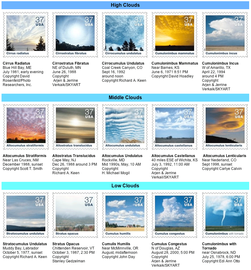
Cloud Stamps
Issued by US Postal Service (Oct 2004). Useful for learning cloud identification. Here is a clearer pdf version .
Clouds develop when moist air cools to its dew point by rising to a higher altitude or by moving over a cooler surface. Water vapor in the air then condenses in liquid or frozen form around minute particles such as pollen or dust. The shapes and altitudes of clouds, as well as the sequences in which they develop, help people forecast the weather.
In the early 19th century, Englishman Luke Howard – chemist by trade and meteorologist by avocation – created a system for classifying clouds using Latin names. He described the three most common shapes as cirrus (curl of hair), stratus (layer) and cumulus (heap); he also defined four compound cloud forms that derive from the three primary shapes, including nimbus (rain). Later scientists added terms such as humilis (small) and incus (anvil) to designate other cloud properties. The International Cloud-Atlas, first published in 1896, is based on this classification system.
Nine of the ten basic cloud genera are pictured on this stamp pane and arranged according to altitude. The prefixes “cirro” and “alto” distinguish high- and middle-altitude clouds, respectively. Nimbostratus, a dark featureless cloud, is marked by falling rain or snow. As the Nimbostratus lacks defined shape, a reproduction of its image through a stamp would appear to be meaningless visually.
Composed of windblown ice crystals, cirrus are fibrous, often wispy clouds that appear in isolated patches or cover large areas of the sky. Cirrus radiatus appear to emerge from the horizon in parallel bands.
Relatively transparent cirrostratus fibratus clouds occur mostly in winter and often produce a halo effect around the sun or moon. Thickening cirrostratus frequently indicate the approach of a frontal system.
Cirrocumulus undulatus are patches or layers of small puffy clouds arranged in patterns. They have a rippled appearance due to wind shear and usually cover only a small portion of the sky.
Pouch-like cumulonimbus mammatus develop when pockets of air chilled by evaporating droplets or ice crystals sink into dry surroundings under the anvil. They usually indicate the approach or departure of a potentially severe thunderstorm.
Cumulonimbus incus, or thunderstorm clouds, form when rapid updrafts within cumulus congestus clouds rise into the upper atmosphere and spread out into mushroom-shaped anvils. Thunderstorms always produce lightning; severe storms may produce heavy rain, large hailstones, or tornadoes.
Small heaps arranged in layers or sheets, altocumulus stratiformis clouds are primarily composed of water droplets and, as depicted here, reflect glorious colors at sunset. If they become thicker during the day, a storm may be approaching.
Altostratus translucidus, cloud sheets formed by the rising and cooling of large air masses, often precede advancing storm systems. A “watery” sun (or moon) may shine dimly through the thinner sections of the cloud sheet.
Resembling ripples on water, altocumulus undulatus clouds result from wind shear – wind speed and direction that changes sharply with height. They may appear as patches or cover the sky.
Named for the turret-like protuberances in their top portions, altocumulus castellanus clouds signify unstable air in the vicinity and often indicate the potential for thunderstorms later in the day.
Smooth, almost motionless altocumulus lenticularis clouds resemble lenses and may be iridescent. They often look like UFOs and form in the crests of waves that occur when strong winds cross over a mountain peak or ridge.
Stratocumulus undulatus occur when weak updrafts spread horizontally, creating a layer of shallow, puffy clouds that is blown by strong winds into wave-like formations that lie at right angles to the wind. These clouds seldom produce precipitation.
Gray, featureless cloud layers that can spread over hundreds of square miles, stratus opacus, like stratocumulus, are generally composed of water droplets. Stratus clouds occasionally produce drizzle or light snow.
Cumulus humilis – the smallest of the cumulus clouds – have flat bases and rounded tops. Usually wider than they are tall, these fair-weather clouds very rarely produce precipitation and often evaporate as the sun sets.
Strong, buoyant updrafts of warm, moist air in an unstable atmosphere cause cumulus clouds to develop into cumulus congestus. These towering clouds can produce moderate rain or snow showers and may grow into cumulonimbus clouds.
Among nature’s most destructive phenomena, tornadoes are rapidly spinning columns of rising air extending between the base of a cumulonimbus cloud and the ground. In extreme cases, tornado winds may exceed 250 miles and hour.
Credits: US Weather Service Office in Sious Falls, SD:
http://www.crh.noaa.gov/fsd/php/cloudstamps2004.php
.