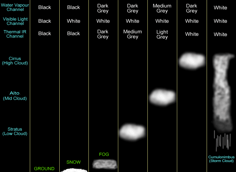
Visible-light (vis) satellite images show all cloud tops as white, regardless of altitude. It only works during daytime, which makes movie loops very short. Also, snow appears white, and can be confused for clouds unless you watch satellite image movie loops (clouds move, but snow is stationary although the areal coverage decreases during melting).
Infrared (IR) images show colder temperatures as brighter whites, and warmer as darker grays. Because temperature decreases with height in the troposphere on average, we can use the simple rule that whiter cloud images correspond to higher cloud tops. IR images can be received both day and night, so it is one of 2 preferred channels for viewing long loops of images. Colour-enhanced IR images often highlight the highest (coldest) cloud tops, which are often the anvils at the top of thunderstorms.
Water vapour (wv) images show the average water content (both vapour and liquid), averaged over a thick range of altitudes in the middle of the troposphere. Brighter whites mean more moisture (including humid air, clouds and rain), and darker grays mean drier air. Low-altitude clouds don't show up at all. Table 1 summarizes these characteristics.
Table 1. Satellite image characteristics. Copyright © 2001 by George Hicks II.
.
Thunderstorms need a trigger to get them started. Some triggers, such as mountains, are easy to monitor for thunderstorm formation. Other trigger mechanisms, such as cold fronts or gust fronts are not so obvious. However, sometimes these fronts are visible in satellite imagery because of the enhanced cloudiness along the front.
Fig Q1 shows an example of a weak cold front in Texas, which is visible because of the greater coverage of cumulus (lumpy) clouds along it. A tan line is drawn just north of the actual cold front, to help you find it. This visible satellite image was taken in mid afternoon. Meteorologists look for lines or boundaries such as this, because they are favored locations for thunderstorm triggering. In fact, when two lines or boundaries intersect, the first or strongest storms are often triggered there.
At this stage, meteorologists don't necessarily know exactly where thunderstorms might form along the front, so the weather service will issue a "Thunderstorm Watch" for a large region outlined by a long narrow box along and just ahead (south) of the cold front (not drawn on this figure). This region is called a "thunderstorm watch box", and indicates that thunderstorms are likely to form somewhere within the box later in the day. This alerts people to keep a close eye on the weather to see what develops, but otherwise they can go about their normal activities.
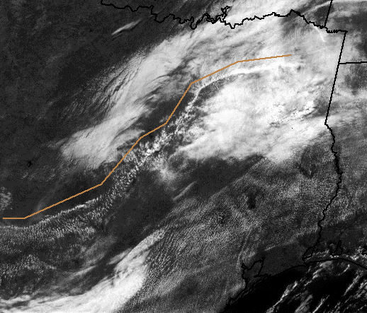 |
Fig Q1. Weak cold front across Texas that will trigger thunderstorms later in the day. Copyright © 2001 by Roland Stull.
As the afternoon progresses, additional heating of the boundary layer by the sun-heated earth adds more fuel (sensible and latent heat ) to the air, and weakens (i.e., partially burns off) the stable layer that caps the boundary layer. This makes thunderstorms easier to trigger -- perhaps easy enough for even the weak cold front of Fig Q1.
Indeed, an hour and 15 minutes later after this first image, a thunderstorm is observed forming near the middle of this cold front (see Fig Q2), outlined with the green circle. Because it is late afternoon and the sun is getting lower in the western sky, we can see a distinct shadow cast under the thunderstorm anvil. The anvil is the bright white oval-shaped cloud mass at the top of the thunderstorm, and the shadow is visible to the lower right of it. This long shadow is a clue that the clouds are very tall, such as would be expected with a thunderstorm. The wispy northeast edge of this anvil cloud is made up of tiny ice crystals, which are being blow downwind of the storm.
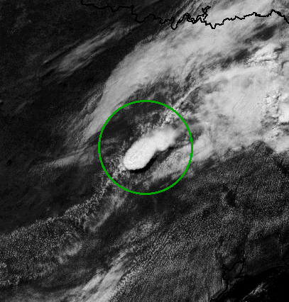 |
Fig Q2. Isolated thunderstorm forming along a cold front. Copyright © 2001 by Roland Stull.
At this stage, the weather service would issue a "Severe Thunderstorm Warning" for a very small region that includes and is just downwind of the thunderstorm. A warning means that there is a storm currently happening, and that people near it should take immediate action to ensure their safety.
Also, for this particular storm, there were clues from radar and upper air soundings that there was sufficient wind speed and wind shear to make tornadoes likely. So a "Tornado Watch" was issued by the weather service, meaning that a tornado is possible out of this severe thunderstorm, even though a tornado hasn't been spotted yet.
By an hour later, in late afternoon, the thunderstorm had grown somewhat explosively due to the abundance of fuel (warm moist air), as can be seen in Fig Q3. A very intense tornado did indeed form in this storm (although not visible by satellite) near the town of Jarrell, Texas, which caused the weather service to issue a "Tornado Warning". The warning means that a tornado was detected, and that people in its path must take immediate shelter, preferably underground in a storm shelter or basement.
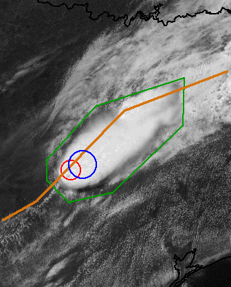 |
Fig Q3. The tornadic thunderstorm as viewed in a visible satellite image, just an hour after the previous figure. Copyright © 2001 by Roland Stull.
In Fig Q3, the red circle shows where the main updraft (the stem of the mushroom) would be. Often this updraft is so strong that it temporarily overshoots above the top of the anvil and into the lower stratosphere, thus casting a shadow on the anvil top. This sort of lumpy structure in the top of the anvil is a clue of where the strong updrafts are. Most of the heavy rain and hail would be falling just downwind (northeast), in the region circled in blue. The tiniest ice crystals are so light that they don't fall very fast, and instead are blown downwind (northeast) into the anvil (the cap of the mushroom), outlined in green. These anvil cirrus clouds are benign and relatively non-turbulent, and can be blown hundreds of kilometers downwind of the storm. The weak cold front that triggered this storm is again shown with the tan line.
Sometimes the air is conditionally unstable enough, and the triggering front is strong enough, to trigger a line of thunderstorms along the front. This is called s squall line. Along this line, new storms are often forming along the southern edge of the line, while the older storms are progressing through their life cycle further north along the line. Fig Q4 shows an example of a long, intense, squall line that extends from Texas in the southwest, across Oklahoma and Kansas, into Missouri in the northeast.
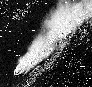 |
Fig Q4. Visible satellite image of a thunderstorm squall line.
As discussed in the thunderstorm triggering section above, the lumpy part of the storm anvil marks where the strong updrafts are, as indicated with the purple line in Fig Q5. This is where the triggering cold front lies. The cirrus (ice crystal) anvil blow-off is outlined in green.
Fig Q6 shows a sketch of the same features (in vertical cross section), as viewed from the southwest looking toward the northeast, along the axis of the squall line. The older storms to the northeast have more extensive blow-off (clouds moving away from the updraft purple line) than the younger storms to the south. On the southeast side of the updraft line is the shadow cast by the anvil, as highlighted with the tan line. Ahead and behind the storm are regions of fair-weather cumulus clouds, the cotton-ball fluffy clouds that form at the top of thermals (shown with the red boxes, and there are more of these clouds outside the boxes too).
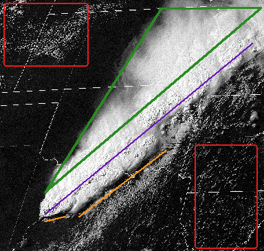 |
Fig Q5. Identification of regions associated with the squall line. Copyright © 2001 by Roland Stull.
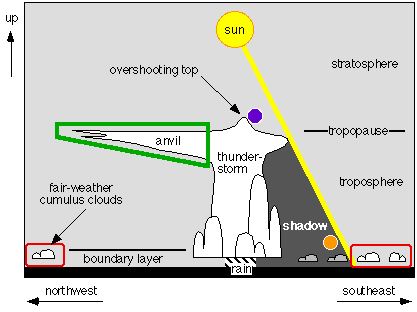 |
Fig Q6. Sketch of thunderstorm features that affect the visual appearance of thunderstorms and squall lines, such as shown in Fig Q5. The coloured regions in Fig Q6 correspond to the coloured regions in Fig Q5. The purple and orange circles represent the ends of the purple and orange lines that were drawn in Fig Q5. Copyright © 2001 by Roland Stull.
.
Hurricanes consist of spiral bands of thunderstorms, where each band is like a squall line. Within each band are the strong thunderstorm updrafts, and at the top of the storm is the cirrus anvil shield that spirals out away from the storm. The tightest circle of thunderstorms is called the eye wall, and often forms around a cloud-free eye in the center of the storm that is often visible by satellite.
Fig Q7 shows an image of hurricane Floyd, with the eye and eye wall just east of Florida. Since we are looking at the top of the storm, the cirrus clouds spiral out clockwise if viewed in animated satellite loops. Hidden under this cirrus shield are is the warm humid boundary-layer air near the ocean surface, which is spiraling counterclockwise (in the N. Hemisphere) inward toward the eye wall.
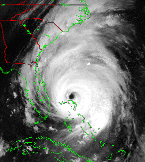 |
Fig Q7. Hurricane Floyd, as observed by a NOAA Polar Orbiter satellite.
Satellites can not only observe the hurricanes, but can measure the warm sea surface temperatures that are needed by the hurricane. Fig Q8 shows the track of hurricane Floyd superimposed on a satellite image of sea-surface temperature. It is obvious that the storm is the strongest (as indicated by the wind speeds in that figure), where the ocean surface is warmest. Hence, satellite images such as these are used by hurricane forecasters determine which regions favor hurricanes.
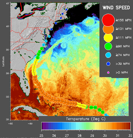 |
Fig Q8. Satellite image of sea surface temperature, with the track of hurricane Floyd (thin black line), and with hurricane intensity as given by wind speed (coloured circles). (Produced by the Johns Hopkins University Applied Physics Lab)
Copyright © 2001 by Roland Stull
.