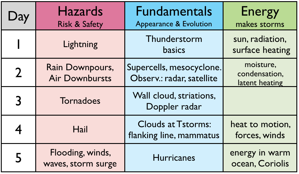
The "roadmap" table below outlines what we cover each day.
Learning Goals (LG) are listed at the end of this web page.
"Monsoon IV", a video by Mike Oblinski, is an optional, but wonderful "teaser" that you can watch before class starts. It shows beautiful time-lapse images of thunderstorm precipitation, downbursts, gust fronts, and other hazards. https://www.youtube.com/watch?v=LbY3DdzV0rA (8:08. Not testable. Can be viewed at 1.5x or 2x speed.)
"Epic Storm Chase", a video by Michael and Shawn Gavian, is another optional storm-chase "teaser" that you can watch before class starts. It shows a mesocyclone (a rotating thunderstorm) that forms a tornado. https://www.youtube.com/watch?v=U9m9XVmfrxU (5:27. Not testable. Can be viewed at 1.5x speed.)
| Fundamentals |
What do thunderstorms look like by weather satellite?
(3:29. Lecture video snippet d2s01.)
YouTube video showing time-lapse (speeded-up) satellite observations of thunderstorms forming and evolving over Texas (in the south central USA). Can you see the anvil clouds and the shadows they cast? Can you see where the updraft "stems" are by the cloudy air that is temporarily overshooting above the rest of the anvil clouds? http://rammb.cira.colostate.edu/dev/lindsey/loops/24may14_g14_vis_texas_loop.mp4 (0:19)
• Visible is what you would see by eye (shown as the greyscale image), as if you were looking at the top of the storm from space. A disadvantage is that visible satellite images are captured only during daytime, when sunlight is illuminating the cloud tops.
• Infrared (IR) is "heat" radiation emitted from clouds themselves, where higher clouds (such as the anvil clouds at the tops of thunderstorms and hurricanes) are colder than lower clouds. In this video, the cloud-top temperatures are indicated with the different artificial colours applied to the image -- red indicates the highest coldest clouds. An advantage of IR is that it works both day and night.
| (Not testable.) This high-resolution video is a series of gif images that might take a long time to load and view in your web browser. Please be patient. This video shows the movie loop of Hurricane Dorian from which the Visible and IR images above were captured. http://cimss.ssec.wisc.edu/goes/blog/wp-content/uploads/2019/09/190901_goes16_visible_infrared_30second_Dorian_anim.gif |
Environment and Climate Change Canada (ECCC) has been replacing old weather radars with new radars across Canada. Here is a photo of a typical radar. The radar at Aldergrove, BC, which covers greater Vancouver, was replaced in 2021. This short 2-minute video explains the capabilities of the new radars. https://www.youtube.com/watch?v=qhXj3s9qwTE
What do thunderstorms look like by weather radar? (2:03. Lecture video snippet d2s02.)
Sometimes thunderstorms form in a narrow line along a cold front?
(0:56. Lecture video snippet d2s03.)
YouTube video by Pecos Hank showing excellent
footage of squall-line thunderstorms and the associated storm hazards
and phenomena. https://www.youtube.com/watch?v=0jkfnIBJRBQ (Play only the first 3 minutes, viewing at normal speed).
Long lasting, intense, rotating thunderstorms are called supercell thunderstorms.
(1:13. Lecture video snippet d2s01.)
YouTube video by Pecos Hank giving an overview of supercells. https://www.youtube.com/watch?v=yvIKIgelY6g (Watch only the first 3:54.)
Low-precipitation (LP) supercells are the most beautiful to photograph. Can produce the most hail. Pecos Hank captured excellent examples of LP storms in this YouTube video https://www.youtube.com/watch?v=yL7Pyw-Rt1I (watch just the first 41 seconds of the video)
High-precipitation (HP) supercells
are wrapped in so much rain that it is difficult to see and photograph
their structure. These are dangerous storms to chase because of
the poor visibility in rain. In Neal Rasmussen's YouTube video
taken under the very narrow wedge of an updraft of an HP storm, you can
see rain in the backgroud and in the left sides of the image. https://www.youtube.com/watch?v=trVMTXoDPGA (0:21)
Not testable. Additional YouTube videos on supercells and mesocyclones.
|
| Hazards |
Large dBZ values on weather radar indicate heavy rain. (1:11. Lecture Video snippet d2s05.)
If thunderstorm rain causes a flash flood on your road, what should you do? https://www.youtube.com/watch?v=eI6mIlHKrVY (0:52.)
Evaporating
rain cools the air under the thunderstorm to cause a downdraft of air
called a downburst, and an outrush of wind that causes a gust front at
ground level. The outrush of wind moves in a straight line, so it
is not a tornado. Nonetheless, it can be extremely
destructive. (5:32. Lecture Video snippet d2s06.)
YouTube video by Ben Holcomb showing a thunderstorm gust front and arc cloud approaching a Michigan
beach from right to left. The thunderstorm and its rain are far
enough away to not be visible in this video. (1:45, when played at 2x speed. https://www.youtube.com/watch?v=mOVwlfrKN2g )
Not testable. Additional interesting YouTube videos on arc clouds and gust fronts.
|
When the outrush of air near the ground picks up sand and dust, the resulting sand storm is called a haboob. Mike Olbinski has some excellent time lapse (sped up) movies of haboobs in the US southwest, in his "Monsoon V" video. Many of his video clips show an arc cloud about the leading edge of the haboob. (skip the first half of the video, and view the segment between times 6:15 and 7:40. https://www.youtube.com/watch?v=TC75USRhdho )
Not testable. More videos about haboobs, gust fronts, and arc clouds:
|
Roland Stull's mis-adventures with weather. Vignette 2: Piloting a small plane through virga. (1:45. Lecture video snippet d2s07.)
Summary slide about downbursts, gust fronts, arc clouds, and haboobs.
| Energy |
A new way to describe humidity. Useful for the concept of saturation — the max amount of water vapour that the air can hold, which depends on temperature. (7:44. Lecture video snippet d2s08.)
As the winds draw more water vapour into the thunderstorm, the air rises and cools, forcing some of the water vapour to condense into cloud droplets. A by product is that the air is warmed, and rain is produced. (2:31. Lecture video snippet d2s09.)
Summary. (0:39. Lecture video snippet d2s10.)
The Learning Goals below are a good study aid
for the topics we covered today. Review
them now to reinforce your understanding.
See you next time, when we learn about tornadoes. Cheers, Prof. Roland Stull.
Learning Goals for Storms Day 2
By the end of this lesson, you should be able to:
2a) list and describe the storm hazards and disaster scales covered in this course.
2b) name and describe the characteristics and hazards of squall lines and of the 3 main types of supercell thunderstorm.
2c) use images and videos from weather radars (reflectivity & Doppler velocity) and satellites (visible & infrared) to identify storm characteristics and anticipate storm changes.
2d) identify downbursts and gust fronts, describe how they form and look, and what their hazards are.
2e) explain how humidity, saturation, latent heat, advection, and adiabatic cooling affect storm energy.