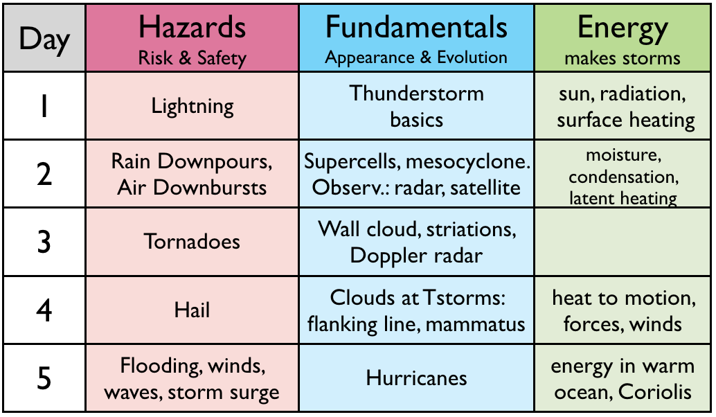
The "roadmap" table below outlines what we cover each day.
Learning Goals (LG) are listed at the end of this web page.
This tornado in Manitoba was photographed on 26 Jun 2007 by Chris Hughes while driving to Alberta. Enjoy this optional short video "teaser" before class starts. https://www.youtube.com/watch?v=xCI1u05KD_s (2:41. Not testable.)
As another optional "teaser" before class starts, Pecos Hank, shows the incredible number of tornadoes he chased in 2016. https://www.youtube.com/watch?v=NZmtglWX0N4 (16:04. Not testable.)
| Hazards |
Types and appearance of tornadoes. (1:36. Lecture Video snippets: Part a d3s01a and Part b d3s01b. )
Relative to a supercell thunderstorm, where is the best place to
view a tornado? (2:17. Lecture Video snippet d3s02.)
| Fundamentals |
Clues of mesocyclone rotation, such as cloud striations. (1:47. Lecture video snippet
d3s03.)
You can see the rotation of this supercell thunderstorm
near Climax, Kansas, only because this YouTube video by Stephen Locke
is sped-up (i.e., is time-lapse). But if it wasn't sped-up, what
clues could you use (looking at the clouds by eye) to infer that the
thunderstorm is rotating as a mesocyclone? https://www.youtube.com/watch?v=Y4EK2r9JJ1k
(1:30; when played at 2x speed.)
Here is another excellent video showing cloud striations, recorded by Freddy McKinney in Nebraska in 2020 https://www.youtube.com/watch?v=zzBylV2QkuI (1:20; when played at 2x speed).
Another clue of supercell (mesocyclone) rotation is a wall cloud. (0:56. Lecture video snippet d3s04.
Doppler weather radar
allow us to detect rotation inside thunderstorms. (1:39. Lecture video snippet
d3s10.)
| Hazards
- Part 2 |
Tornado translation across the countryside, and intense rotational wind speeds that cause destruction. (2:34. Lecture video snippet d3s05.)
The Enhanced Fujita scale for tornado intensity, as illustrated
in this YouTube video by Pecos Hank. https://www.youtube.com/watch?v=c-uFdoi6DEA
(5:38 )
Tornado damage -- another perspective. (0:56. Lecture video snippet
d3s06.)
YouTube video of a small car carried away by a tornado. https://www.youtube.com/watch?v=nddkiXuM4Ag
(watch the first 30 seconds)
YouTube video from a "dashcam" on a locomotive that is looking backwards over the remaining train cars, as the train is derailed by a tornado. https://www.youtube.com/watch?v=LYubpuIe3cw (0:43) .
Tornadoes are usually short lived, with narrow damage paths as shown in this image. Longer lasting, larger size (see another image) tornadoes exist, but happen only rarely.
Tips on how to survive a tornado. (1:52. Lecture video snippet d3s07.)
Where is the greatest risk of frequent tornadoes? (1:21. Lecture video snippet
d3s08.)
Here is the world map showing locations of frequent tornadoes. Here is an updated map showing newer understanding of the "tornado alley" region.
Tornado Hits UBC ! Although tornadoes in the Vancouver area are extremely rare, an EF0 tornado hit UBC in late 2021. The tornadic thunderstorm approached from over the water, and then moved across the Point Grey peninsula, causing tree damage in Pacific Spirit Park and at the UBC Golf Course. The mesocyclone had both a hook echo and a Doppler-radar signature of a tornado.
Sometimes many tornadoes happen in a few days? (2:13. Lecture video snippet
d3s09.)
This slide shows the five stages of supercell tornado evolution.
Be cautious if you are watching or photographing a tornado, because a
new tornado might be forming from the same supercell while you are distracted when focused on the old dissipating tornado.
Tornado watches and warnings, including ...
...Roland Stull's mis-adventures with weather -- Vignette 3.
(2:00. Lecture video
snippet d3s11.)
Summary slide listing the topics we covered in this lesson. Next time we will learn how the heat released in thunderstorms causes the violent winds. We will also look at hail hazards.
The Learning Goals below are a good study aid
for the topics we covered today. Please review
them now to reinforce your understanding.
See you next
time. Cheers, Prof. Roland Stull.
By the end of this
lesson, you should be able to:
3a) describe tornado shapes, what makes them visible, and where they form relative to a thunderstorm.
3b) use photographs & videos to identify the tornado intensity on the enhanced Fujita scale.
3c) describe characteristics of tornado evolution, tornado outbreaks, and mesocyclones.
3d) explain tornado hazards and safety procedures, and times and locations of greatest risk.
3e) explain the difference between tornado watches and warnings, and appropriate safety responses.