Apply fossil and geologic data to estimate the location of an ancient coastline.
Like we said before, this is not a quiz. The activities will help you address each aspect of this task. "Answers" are provided but don't just skip to the answers. Use your brain to figure stuff out.
You may want to have the figure with five fossils in a separate browser tab, or you could print a copy.
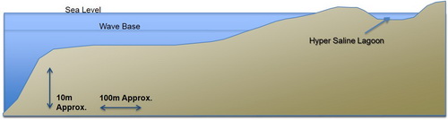
Also, note that questions 1-6 use this purly diagramatic image to help us relate fossils to their depositional environment. It does not represent a "real" location.
Now - click the figure suggesting a rough location for fossil A.
Now - click the figure suggesting a rough location for fossil B.
Now - click the figure suggesting a rough location for fossil C.
Now - click the figure suggesting a rough location for fossil D.
Now - click the figure suggesting a rough location for fossil E.
Having said hyper-saline water is inhospitable to MOST life, what special kind of fossils CAN occur (the corresponding primitive organisms still occur today in a few locations)?
These remaining questions are about interpreting the paleogeography of the location where fossils were found. Fossil E was found in a rock unit that (a) was cross cut by volcanic dyke dated at 70MY and (b) lies on top of an igneous intrusion dated at 100My. This helps constrain the age of that rock unit to (roughly) ...
older than 100My
younger than 70 My
about 100My
about 70 My
Younger than 100My but older than 70My
Not enough information to estimate an age or age range
Meanwhile, fossil B was found at a nearby location in a rock unit that was (a) two facies units above fossil E, (b) outcropping with nothing visible above, and (c) with no obvious cross cutting units that could be dated. Based on this information, the best we can say about the age of fossil B's rock unit is that it is ...
older than 100My
younger than 70 My
Older than fossil E's rock unit
Younger than fossil E's rock unit
Younger than 100My but older than 70My
Not enough information to estimate an age or age range
Assume that the rock units containing fossils E and B were found laterally not very far apart, and keep in mind the timing relationship you just identified between the two rock units. What does this tell you about what was happening to sea levels at our location, between deposition of the oldest and youngest of these two samples?
Sea level was rising between deposition of fossils E and B.
Relative sea level was falling between deposition of fossils E and B.
Relative sea level remained roughly the same between deposition of fossils E and B.
There was at least one instance each of rising and falling between deposition of these fossils
There is not enough information to make any bold statement about variations of relative sea level around the times when these two fossils were deposited.
What evidence was necessary for making this judgement about variations of sea level? Pick all that apply, but do NOT pick items that are true but not relevant for this question.
This photograph represents a modern-day analogue for ancient coastal environments. Are there any of our five fossils that you think could NOT have formed at some location within this photograph? Click boxes to indicate which fossil(s) could NOT have formed here.
Revisit your thoughts on evidence: Do you have any new thoughts about the kinds of evidence geologists might use to decide about locations and times of ancient coastlines.
Revisit our purposes: Why should we want to apply fossil and geologic data to estimate the location of an ancient coastline? Has your mind changed regarding the one or two ideas that suggest why this task could be interesting or perhaps even useful to some individuals or organizations? Make a few notes on these points.
 Revisit your thoughts on evidence: Do you have any new thoughts about the kinds of evidence geologists might use to decide about locations and times of ancient coastlines.Revisit our purposes: Why should we want to apply fossil and geologic data to estimate the location of an ancient coastline? Has your mind changed regarding the one or two ideas that suggest why this task could be interesting or perhaps even useful to some individuals or organizations? Make a few notes on these points.
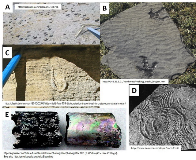