| |
On this page are corresponding regional airborne magnetic data and a geology sketch presented at the
same scale. Magnetic anomaly values are in nanoteslas relative to an
arbitrary reference near 57800 nT. Note that Lat / Long are in decimal
degrees. UBC geology field school exercise locations, and the camp location itself, are marked on the maps. The geology sketch legend is provided below.
Figure 1: Magnetic anomaly map
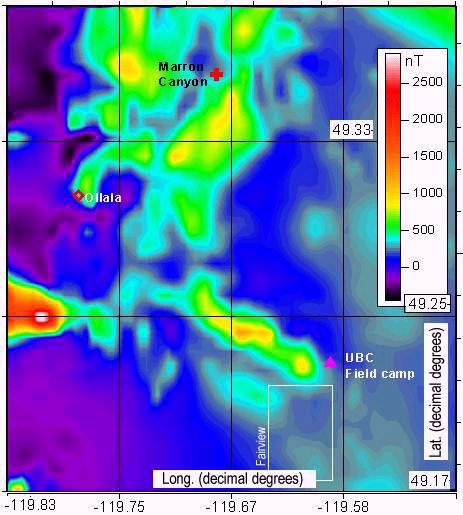
Figure 2: Geology sketch
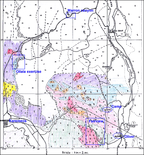
Key for the geology sketch:
|
6
|
Jur?
|
Olalla pyroxenite and syenite |
|
T
|
Tr?
|
geosynclinal cherts, greenstones, argillites |
|
Ls
|
Penn +?
|
Blina Ck and Ollalla limestones |
|
K
|
Up Pz
|
Kobau: metamorphics |
|
S
|
Lw Pz
|
Shuswap: metamorphics |
|
.........
|
Quat
|
glacio-lacustrine silts sands gravels |
|
w
|
Olig/Eoc ?
|
White Lake: seds, lahars, pyroclastics, flows |
|
M
|
Eoc/Olig?
|
Marron: andesites, dacites, trachites, etc and pyroclastics |
|
ooo
|
Lw Tert
|
Springbrook: seds, mainly conglomerates and breccia |
|
g
|
Jura
|
plutonics 1: granodiorites, qtz monzonites diorites |
|
q
|
Jura
|
plutonics 2: granodiorites, qtz monzonites diorites |
|
d
|
Jura
|
plutonics 3: granodiorites, qtz monzonites diorites |
|
|
