|
Geophysics foundations:
|
|
|
|
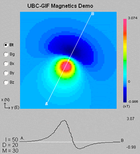
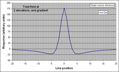
Left: The total field and gradient responses above a dipolar magnetic anomaly are shown for a location where inclination is 50o, and declination is 20o. |
In addition to higher spacial resolution, temporal variations are automatically eliminated because the measured parameter is a difference of two total field measurements. Therefore, the base station measurements and subsequent data corrections normally required for total field surveys are not required. If the goal is to map variations in geological materials, then more subtle trends in magnetic response must be observed.
Data acquisition of total field magnetics or gradient magnetics is very rapid. For finding buried objects, simple anomaly detection is often adequate since the depth of burial and quantitative estimates of physical properties may be unimportant. Under these conditions, rapid acquisition of spatially dense data sets is usually required, and results are often presented with minimal processing. The most important survey design consideration is to avoid spatial aliasing. For small 3D targets such as buried drums or other objects, a tightly spaced grid would be required; while for 2D targets such as buried utilities, data spacing along profile lines would likely be much tighter than spacing between lines. This assumes that lines can be placed perpendicular to target orientation.