| |
Seismic data are routinely acquired using a source and multiple receivers.
The entire array is progressively moved along.
There are several common geometries for the "instrument"
- that is the configuration of sources and receivers.
- The simplest is a
"common offset" array in which the source and receiver distance is always
the same. This is the way most GPR surveys are performed. Signals at
one receiver are recorded from the shot (or source), then the shot-receiver
are moved to a new location and the process is repeated.
- A variation on this is the "optimum offset" array in which many receivers
are recorded for each shot. Then the shot and receiver string are moved
to a new location and the process is repeated. This works well if targets
are relatively shallow (perhaps less than 100m or so) AND if reflecting
horizons are clear and distinct (ie if the acoustic properties vary significantly
and sharply across the boundaries).
- The most common, though most expensive, form of surveying is the "multichannel
relfection survey". As for optimum offset surveys, many receivers are
used for each shot. The difference is that the survey system is carefully
designed so that each reflecting point in the subsurface is sampled more
than once. In other words, the objective is to obtain several different
echoes (reflections) from identical subsurface points. This type of surveying
involves some care in setting up the field work, and some effort in the
processing steps. Details will be covered next.
Multichannel Reflection Survey
First consider the source-receiver geometry. The geometry can be "split
spread" in
which case there is a central shot with receivers on both sides, or a "single-ended
spread" in
which the receivers are always on one side of the source. Split spreads
are common in land surveys; single-ended spreads are common in marine surveys.
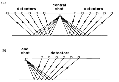
Shot-detector configurations used in multichannel seismic
reflection profiling.
(a) Split spread, or straddle spread. (b) Single-ended spread. |
Click for larger image |
| Both from Kearey, Philip and Micheal
Brooks, An Introduction to Geophysical Exploration. 2nd
ed. Blackwell Science: 1991. |
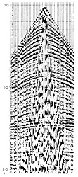
A split spread seismic record is shown above right. The seismic traces
all belong to a single source and hence this is referred to as a "Common
Source Gather". The first arrivals are direct or critically refracted arrivals.
Reflection hyperbolae from numerous boundaries are observed. The strong
energy in the triangular central portion is ground roll caused by surface
waves. It masks the reflection events.
Fundamental procedure
In order to benefit from gathering several echoes from each reflecting
point there are numerous operations that need to be applied to the data.
Much of the data processing is tied to the hypothesis that the earth's
properties vary most strongly in the vertical direction. The table shown
next illustrates the fundamental procedural concept underlying the
creation of a final seismic reflection section:
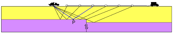
Objective:
We want to characterize the earth using echo sounding with this geometry: |
(1)
 |
Reason for using many "redundant" echoes -
to reduce noise:
We need to gather several versions of the experiment and stack: |
(2)
 |
Logistics:
However, surveying with one shot and many geophones is more cost-effective: |
(3)
 |
Therefore:
Field work must be arranged as follows. Blue
italics text refers to the figure below.
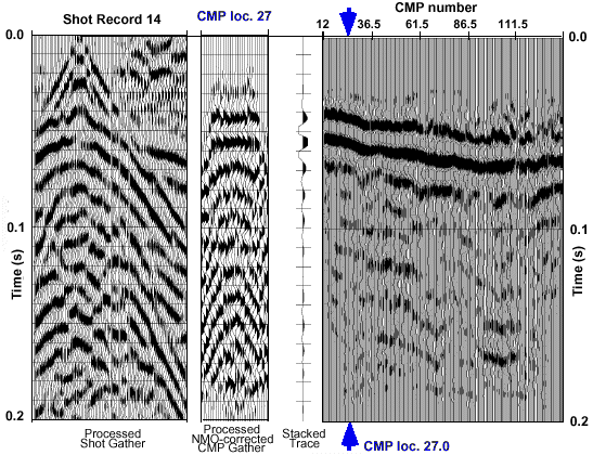
- We gather data using the geometry of type (3).
Data from one shot into many geophones
("common shot data") are shown below under the label Shot Record
14.
- Next, sort many of these "common shot data" so that traces appear
as if gathered using the geometry of type (2).
All traces that reflected under one location
are collected into a "common mid point gather", one from each of
many common shot data sets. See the panel under CMP loc. 27.
- Stack these traces to produce one trace which represents measurements
obtained using the desired geometry of (1). This is the CMP (common
mid point) trace.
This is the single trace next to the CMP
panel.
- Then many of these CMP traces are combined into one cross
section of the earth's structure.
Traces are labelled CMP number, and
the one trace shownis identified with arrows.
- Interpretation in terms of geology is the final step.
|
|
The procedures to accomplish these steps will be explained in subsequent
pages of the notes.
© UBC EOS, D.W. Oldenburg and F. Jones |
|