| |
Seismic Sources
 For seismic surveying purposes there are a number of generic goals. Not all of these objectives can be met perfectly, but sources are designed to meet them as effectively as possible. For seismic surveying purposes there are a number of generic goals. Not all of these objectives can be met perfectly, but sources are designed to meet them as effectively as possible.
- High energy is required - the stronger the source, the better the signal to noise ratio.
- High frequency is preferred - the higher the frequency, the shorter the seismic pulse and hence the better the resolution. HOWEVER, high frequencies are attenuated more quickely and hence to not travel to such great depths as lower frequencies. See "resolution".
- Repeatability is important for reliable measuremnets - we often want to stack the signals to improve the signal to noise ratio so repeat "shots" should all have identical source energy characteristics.
- A well defined source signature is desirable. By this we mean that the exact pattern of the wave energy should be known. If it is, we can use deconvolution to find the exact times of reflections &/or refractions. Recall that deconvolution is a processing step that enhances reflections and/or refractions.
Land Sources:
There are many ways of making the earth move suddenly so that seismic signals are generated, and their traveltimes can be recorded.
- Explosives: To get good coupling the explosive should be detonated in a shallow shot hole. Explosives are generally not repeatable and may not be environmentally friendly.
- Buffalo guns are common for small scale engineering / environmental work. See the figure below for a diagram of this type of source.
- A simple heavy hammer on a baseplate is inexpensive and safe for small jobs (photo above and on the introductory page). When shear waves are required, a baseplate with ribs that penetrate the ground is used, and it is struck on it's side. This is one of the few simple ways of producing shear waves.
- Finally, vibroseis is an expensive source is used mainly for reflection surveying. The input is a frequency varying sinusoid (called a chirp signal). Multiple vibrators are often used. There are systems ranging in size from handheld units like pavement packers through to massive special purpose trucks that can be used singly or in coupled groups to produce signals that penetrate beneath the crust into the mantle of the Earth.
|
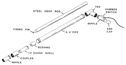
Diagram of a "Buffalo gun" seismic source. The 3/4 inch pipe with the shell installed is lowered into a borehole of the same size, then the steel drop rod is dropped through the tee so the firing pin strikes the 12 guage shell. This creates the seismic energy. |
Water Sources
When seismic surveying is needed to characterize ocean, lake or river bed sediments, special sources of seismic energy are required. A few of these are listed here:
- Air gun: Compressed air is released to the water, forming a bubble. As the bubble rises to the surface it pulsates creating an extended source signature.
- Water gun: Water is ejected by a piston and there is a cavity behind the water jet. There is an implosion but no bubbles because no extra air has been introduced.
- Sparkers: The electric charge held on a large bank of capacitors is discharged directly into the water. This Ionizes the water and creates a plasma pulse. Voltages of ~4kV, and currents of ~200A are involved.
- Boomers: These involve the discharge of capacitors through a coil. The changing voltage impinges upon an aluminum plate and the interaction of the magnetic fields drives the plate backward.
Seismic Detectors
How are the tiny ground motions detected? A seismic detector is an electromechanical device. It responds to a mechanical input such as physical motion or pressure, and outputs and electrical signal.
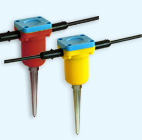
On land the instruments are called seismometers or geophones. Once the sensor's spike (right) is planted into the ground, the geophone case moves with the ground while a heavy magnetic inside the case stays stationary owing to it's own inertia. The relative motion between a coil wrapped around the magnet, and the magnetic field, sets up an voltage in the coil. This voltage is passed along the wire to the recorder where it is converted to a digital signal and stored. |
 |
Geophones are sensitive to motion only along the axis of the coil. Vertical ground motion is best detected by a orienting the coil vertically to build a vertical geophone. It is also possible to mount the spring/mass system horizontally. A combination of several sensors in different orientations allows ground motion in all three directions to be measured.
Seismic signal detectors for water-borne deployment are called hydrophones. These are generally ceramic piezoelectric elements which produce an output voltage proportional to the pressure variations associated with the passage of a compressional wave through the water. At sea, these are often carried in a neutrally buoyant cable (seismic streamer). Recall that shear waves can not travel in liquids.
Recording equipment
 Seismic data consists of records of ground motion at each geophone location. Each record shows how ground moved as a function of time, starting at the moment the source energy was generated. The records are usually a few hundred milliseconds long, and are digitized (ie sampled) at a sampling rate of perhaps several samples per millisecond. This is not very different from the sampling rate for digitized music. Therefore, recording equipment must have the following capabilities: Seismic data consists of records of ground motion at each geophone location. Each record shows how ground moved as a function of time, starting at the moment the source energy was generated. The records are usually a few hundred milliseconds long, and are digitized (ie sampled) at a sampling rate of perhaps several samples per millisecond. This is not very different from the sampling rate for digitized music. Therefore, recording equipment must have the following capabilities:
- One electrical signal to digital number converter for each geophone, which can work at "audio" frequencies.
- A synchronizing facility so that digitizing can start at the same time as energy is initiated at the source.
- A computer to manage the many streams of numbers coming from all the geophones.
- The computer must be able to "replay" or plot the seismograms (signals from each geophone) so that data quality can be checked visually. Some units will have a small strip-paper printer.
- Since there is a computer, most systems include built in software to carry out intial interpretations of refraction data. Processing reflection data is more complicated and usually requires "off line" work back home at the office.
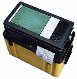
The image to the right is a "SmartSeis" seismograph which can record up to 24 channels, manufactured by Geometrics. A good place to see specifications of engineering scale seismic equipment is http://www.terraplus.ca/products/seismic/ (Terraplus is an equipment rental company, based out of Richmond Hill, Ontario).
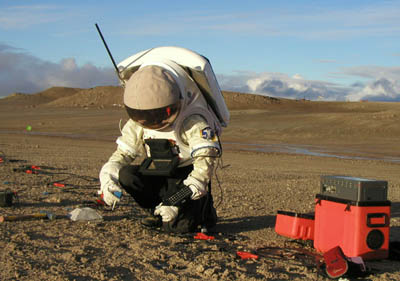
Below is an image showing simulated exploration of Mars at the Haughton-Mars Project, an international, interdisciplinary field research project. The “Mars analogue” field site is in the Haughton crater, a meteorite impact crater, on Devon Island in Canada's high arctic. A line of geophones is being planted, the seismograph is nearby. The goal is to characterize the layered structure under the field site.
|
|