Return to: [Eosc452
home ]
.
|
Return to: [Eosc452
home ]
.
Example of a journal entry |
Every student is required to work on a learning journal during the term. Please refer to the syllabus for a description of what is expected, and how it will be marked. Here is an example entry. Feel free to use your own format. However, remember that the objective is to give you an opportunity to think about how the newly learned information in this course can be applied to an area that you are interested. There is certainly room for more discussion in each section - this is meant to be a “minimal” example journal entry.
This was an introductory week. Most of the time was spent outlining the course syllabus, class activities, lab exercises, and so on. However we did examine briefly portions of an article from APEGBC. (reference below). The objective seems to have been to gain a preliminary understanding of how geophysics contributes to earth science problems, particularly mineral exploration and geotechnical engineering.. We did not read the whole article in class, but I finished it at home.
The geotechnical example in the article has a hydrology task as part of the reason for doing the work. Mapping potential paths for groundwater was a concern, though they don’t explain why. However the site was at tailings of a mine site, so presumably there was some concern as to where contaminated water could flow.
The geophysical work for this problem included DC resistivity, and the outcome of the work was in the form of a 2D model of the electrical resistivity (this means a cross section I assume). Both raw data and inversion result were shown in Figure 4 (below). The raw data has no vertical axis so depth is not interpretable, whereas the inversion result does have a depth axis. I am still a bit puzzled as to how the conversion works, but evidently that will be the subject of one section of the course. I noticed that they said interpretation of precise depth for the bedrock interface would require a drill hole. I guess this is because the image does not make it clear whether bedrock starts where resistivity is coloured in red, yellow, blue, or whatever.
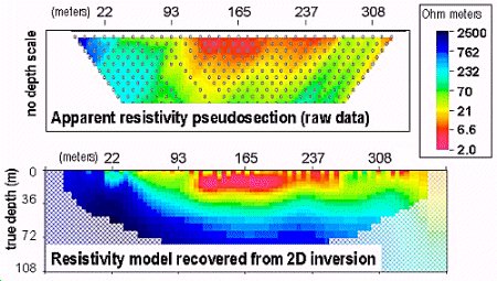
Even with this rather brief introduction, it seems clear that geophysical data has provided information that is critical to the problem - i.e. what is the bedrock topography under the survey line. It seems that conventional geotechnical work is still imperative. Drill is noted as necessary if true depths can be found. As a professional in charge of the hydrogeologic part of this project, I would have to recommend the geophysical work as well as drilling. However, perhaps more geophysical work and less drilling could be justified if detailed shapes of bedrock topography can be mapped.
Geophysical Inversion - New wasy of seeing the Earth’s subsurface, Francis Jones and Doug Oldenburg, Innovation, Oct. 1999. (APEGBC’s monthly magazine).