ATSC 113 Weather for Sailing, Flying & Snow Sports
Updrafts for Soaring
Learning Goal 2f. Relate updrafts for soaring to causes including thermals, anabatic winds, and mountain waves
Soaring
• Unpowered gliders/sailplanes cannot take-off on their own. Instead, they need to be towed by another aircraft to a good starting altitude, or are launched with ground-based winch systems.• Motor gliders have a small engine and propellor that they can turn off in flight.
• Hang gliders and similar aircraft are launched from hilltops.
Once airborne, these soaring aircraft need atmospheric updrafts to stay aloft - - without updrafts the gliders will gently descend down toward the ground. So any weather phenomenon that provides smooth reliable updrafts is usually welcomed by soaring pilots.
Certain weather phonomena produce large regions, or long bands of updraft. Examples are mountain waves and anabatic winds along mountain slopes. Smaller, localized updrafts are found within thermals. But sometimes these thermals are aligned into rows that enable long distance soaring - - the clouds at the top of these thermal rows are called cloud streets.
Mountain Waves
When the wind moves air of correct static stability over a mountain range, the air to the lee (downwind) of the mountain can oscillate up and down as a mountain wave, as sketched below. Further details can be found in Learning Goal 3d.
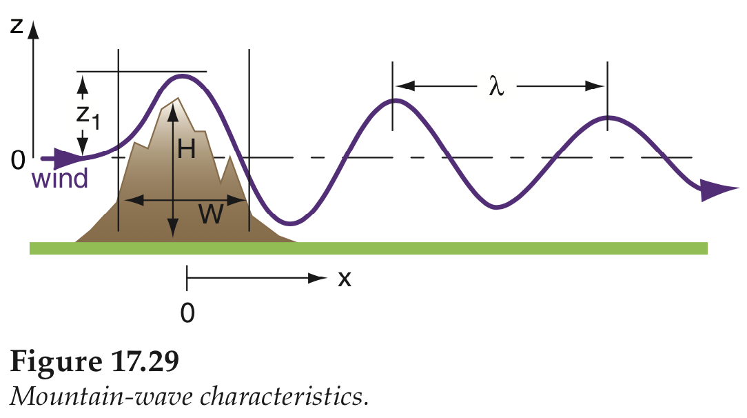
Thus one portion of each wave has an updraft, and the other portion has a downdraft. The rectangles in the figure below shows the updraft regions, where sailplane pilots would like to soar. (The height z and downwind distances x in this figure are just one example. On other days, the waves might have different amplitudes (up and down height) and different wavelengths (distance between crest and neighboring crest).
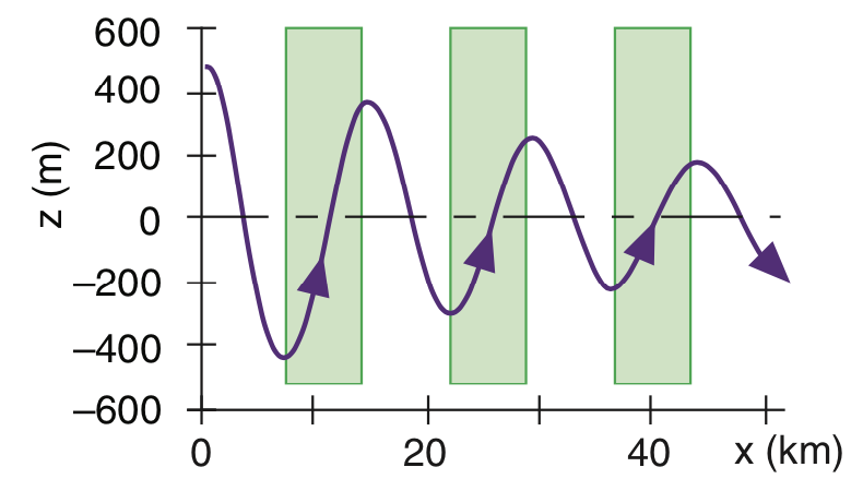
One of the characteristics of mountain waves is that the locations of the crests and troughs (and also of the updraft regions) shift upwind (to the left in this sketch) with increasing altitude, as indicated by the thin dashed lines in the diagram below. As a sailplane soars to higher altitudes in mountain waves, the pilot should try to gradually move upwind (toward the mountain location) in order to stay in the maximum updraft.
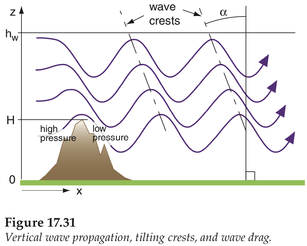
If you look closely at the figure above, you will notice that the wavy lines representing the winds at different altitudes are closer to each other in the downdraft portion of the wave and further apart in the updraft. This means that the downdraft regions have strong downward speeds, while the updraft regions have gentler updrafts.
Not shown in the figure above is that the wave amplitude (z1
in the first figure of this web page) often increases with increasing
altitude due to the lower air densities at higher altitudes. Some
sailplanes are designed to use mountain waves to soar at extremely high
altitudes, even up into the stratosphere where the wave amplitudes are
very large.
In September 2018, the Perlan 2 glider used mountain waves caused by very strong jet-stream winds hitting the southern Andes mountains to soar to an altitude of 74,298 ft (22,646 m) MSL, which set a new record. They had taken off from Comandante Armando Tola International Airport (Aeropuerto de El Calafate) in southern Argentina.
Also not shown is that, depending on the downdraft speeds and amplitudes, the waves might "break", which causes violent turbulence that could harm a sailplane.
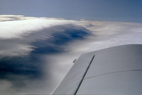
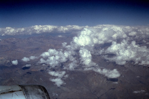
If the mountains have very long ridge lines and relatively rounded
tops, the mountain waves can form downwind of the whole ridge line. For
example, the Appalachian Mountains have some ridges that are 1000 km
long (see the photo below that I took above mountain wave clouds in
long bands over the Appalachian Mtns.). If the wind is blowing across
these ridges, then sailplane pilots
can fly parallel to the mountain ridge, at just the right distance
downwind to remain in the updraft portion of the wave. This allows them
to set distance records of over 1000 km. See other lenticular
cloud photos in Learning Goal 1b.
Thermals
When sunlight heats the ground, the ground warms the air touching it. This warm air rises as thermals. As the thermals gently drift downwind, birds and soaring pilots stay with the thermal (i.e, also move gently downwind) to get the maximum lift. If the larger scale winds are relatively light or calm, then the thermals are coherent (the updraft is well defined and vertically aligned or slightly tilted) over most of the depth of the thermal (see figures below).
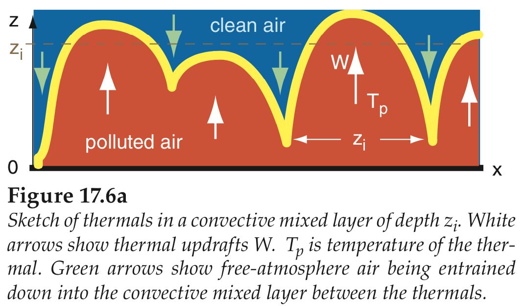
Birds and sailplane pilots enjoy circling in the updrafts to gain altitude. Between the thermals are downdrafts of return flow. The thermals are typically shallow (100 m deep) in the early morning, and can be as deep as 1 to 4 km by mid afternoon, depending on the location, the dryness and color of the soil, and the intensity of the sunshine. This layer of thermals is called the convective boundary layer. The convective boundary layer is often more polluted than the clearer air above, allowing laser radars (lidars) to see the boundary-layer thermals (see figure below) by the air pollutants carried by the air. The diameter of each thermal is roughly equal to its depth (zi), so thermals have larger diameters later in the day compared to in the morning.
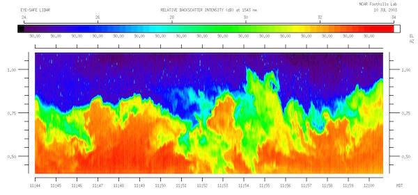
— This lidar (laser radar) image show the air pollution (reds and yellows) from surface sources being carried upward inside thermals. The clean air above the region of polluted thermals is blue in this false color photo. Courtesy of Shane Mayor.
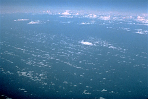
If there is enough moisture in the air, then a cumulus cloud (see Learning Goal 1a) might form in the top portion of each thermal. These clouds help the sailplane pilot locate the updraft regions.
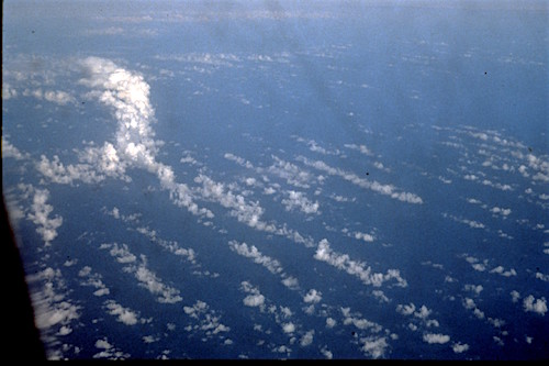
If you are lucky, then with a moderate wind, the thermals could be aligned into rows that are approximately parallel to the wind direction. If there are cumulus clouds at the tops of these rows of thermals, then the rows of clouds are called cloud streets. Cloud streets and the updrafts under them allow sail-plane pilots to soar for long horizontal distances under those clouds.
Anabatic Winds and Anabatic Cumulus Clouds
During light or calm wind conditions, if the sun heats mountain slopes, then the thermal updrafts preferrably follow the mountain slope until the updrafts get to the ridge top. Above the ridgetop, the thermals rise vertically. These warm updrafts along the mountain slopes are are called anabatic winds or anabatic circulations. If the air has sufficient humidity, then cumulus clouds might form at the tops of these rising thermals. These are called anabatic cumulus (labled "Cu" in the figure below) and are found along the mountain ridgelines. Again, these are preferred regions for soaring, although the thermal updrafts are turbulent and irregular (not smooth and continuous like a mountain wave).
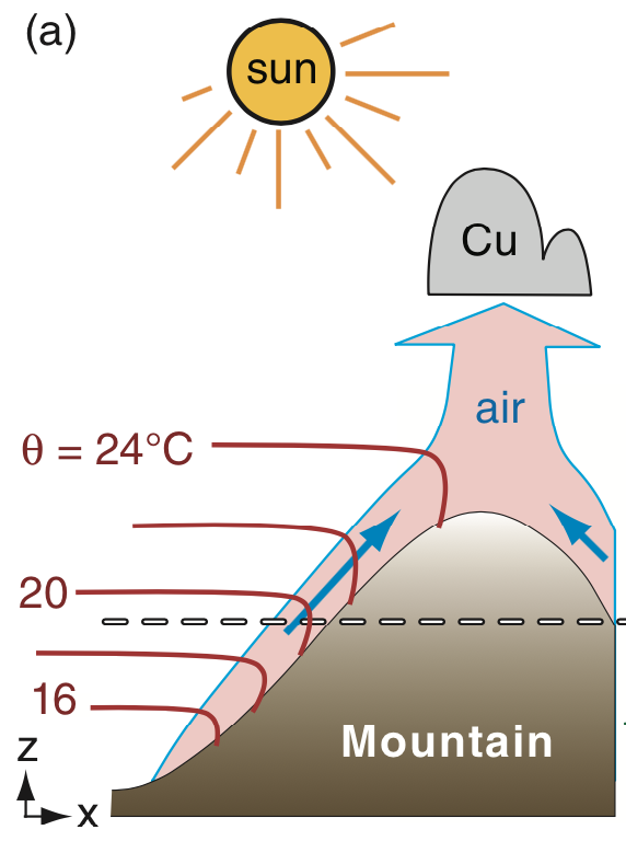
Diagram of anabatic upslope flow. (The red lines are potential temperature; not covered in this course.)
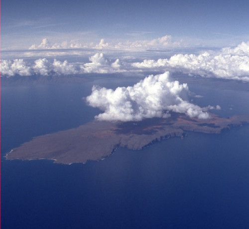
Anabatic cumulus clouds over the Hawaiian Islands.
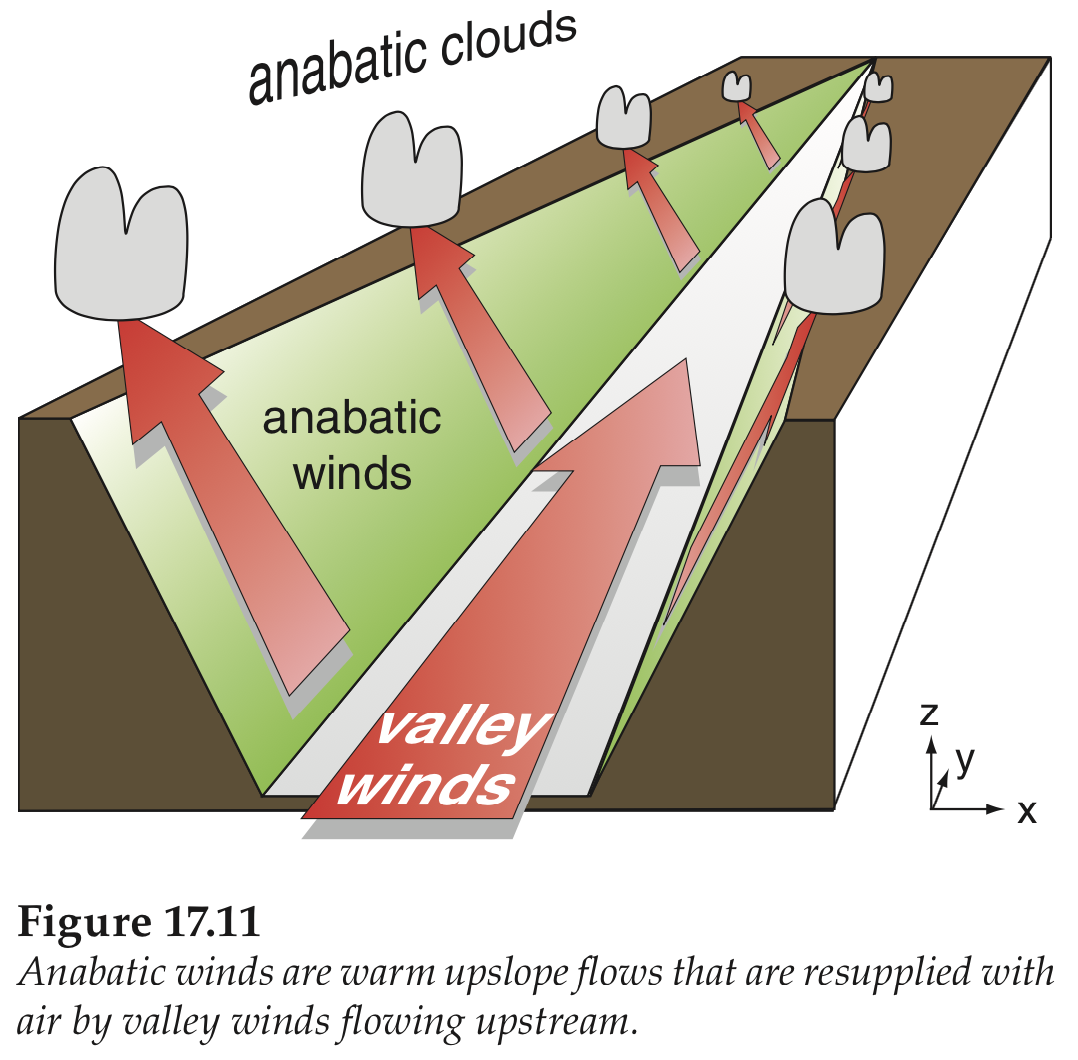
Associated with the anabatic cross-valley circulations is an along-valley wind blowing very gently upstream during the daytime. This is called a valley wind.
Anabatic clouds aligned along mountain ridges.
CAUTION: If you are soaring in anabatic conditions, keep a close eye on the weather in case the cumulus clouds start to grow into thunderstorms. Orographic thunderstorms (associated with mountains) are common in mountainous regions if sufficient moisture is available.
Some weather services provide soaring forecasts:
- NWS Salt Lake City , US Pacific Northwest from Spokane or Spokane2 ,
- Weather Online (worldwide)
Key words: cumulus cloud, anabatic wind, anabatic
circulations, anabatic cumulus, updraft, downdraft, cloud streets,
mountain waves, convective boundary layer, cloud streets, valley wind,
thermal, orographic thunderstorms
Extra info for experts; not needed for this course.
- FAA Glider Handbook Chapter 9: Soaring Weather.
- Wikipedia: Gliding.
- Practical Meteorology 2017: Chapter 17 on Regional Winds.
Image credits. All the photos were taken by Roland Stull, and the drawings were made by Roland Stull, and all are copyright by him and used with his permission.