Thunderstorm Hazards > Hail
Learning Goal 4f. Identify thunderstorm hazards to flight &
how to avoid them. Hail.
What is hail?
Hailstones are irregularly-shaped balls of ice, larger than 0.5 cm in diameter, that fall from severe thunderstorms. The event or process of hailstones falling out of the sky is called hail. The damage path on the ground due to a moving hail storm is called a hail swath. Hailstones often consist of layers of clear and white ice (white because of small air bubbles trapped in the ice).
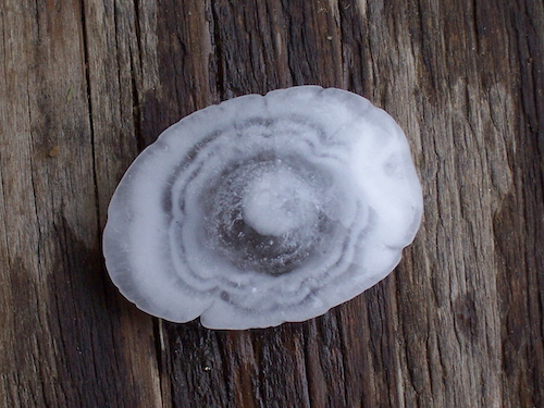
© User:EZR / Wikimedia Commons / GFDL
Most hailstones are in the 0.5 to 1.5 cm diameter range, with about 25% of the stones greater than 1.5 cm. While rare, hailstones are called giant hail (or large or severe hail) if their diameters are between 1.9 and 5 cm, and hailstones with diameters ≥ 5 cm are called significant hail or enormous hail. One stone of diameter 17.8 cm was found in Nebraska, USA, in June 2003. The largest recorded hailstone had diameter 20.3 cm and weighed 878.8 g — it fell in Vivian, S. Dakota, USA on 23 July 2010. Hail that is smaller than 0.5 cm is called graupel.
Watch this video for an excellent intro to hail: https://www.youtube.com/watch?v=6JbU0dIq70E
Hailstone diameters are sometimes compared to standard size balls (ping-pong ball = 4 cm; tennis ball ≈ 6.5 cm). They are also compared to non-standard sizes of fruit, nuts, and vegetables. One such classification is the TORRO Hailstone Diameter relationship.

Why does hail get so large?
The terminal fall velocity (i.e. fall speed) of hail increases with hailstone size, and can reach magnitudes greater than 50 m/s for large hailstones.
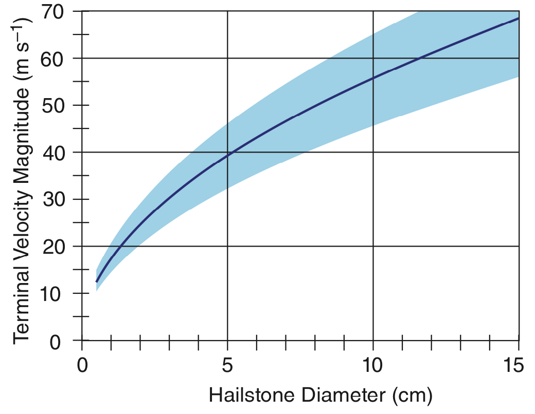
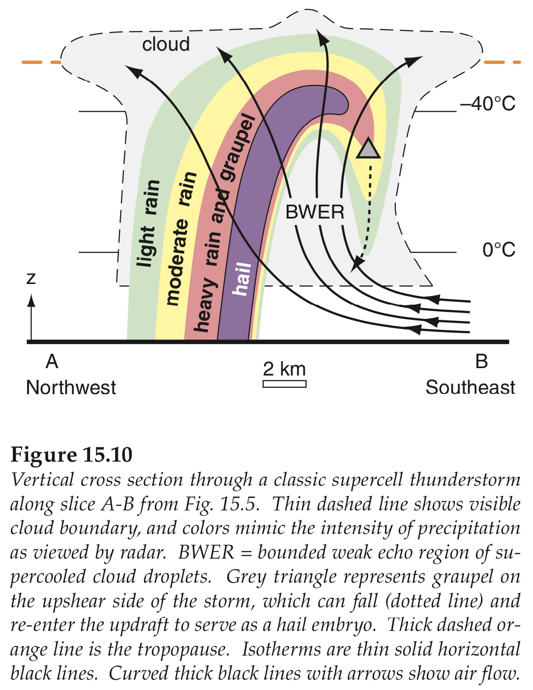
The only way that large hailstones can form is if the air updraft speed in the thunderstorm exceeds the terminal fall velocity of the hailstone. Thus, larger hail forms in the more severe thunderstorms (supercells) with stronger updrafts. The hail that does fall often falls closest to the main updraft, and the resulting hail shaft (the column of falling hailstones below cloud base) often looks white or invisible to observers on the ground.
Most hail falls are relatively short lived, causing small (10 to 20 km long, 0.5 to 3 km wide) damage tracks called hail swaths. Sometimes long-lived supercell thunderstorms can create longer hailswaths of damage 160 to 320 km long and 8 to 24 km wide. Even though large hail can be extremely damaging, the mass of water in hail at the ground is typically only 2-3% of the mass of rain from the same thunderstorm.
Where is the greatest hail risk in North America?
|
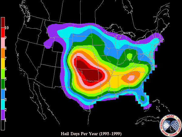
In the USA, most giant hail reaching the ground is found in the central and southern plains, centered in Oklahoma (averaging 6 to 9 giant-hail days per year), and extending from Texas north through Kansas and Nebraska (3 or more giant-hail days per year). Hail is also observed less frequently (1 to 3 giant-hail days per year) eastward across the Mississippi valley and into the southern and mid-Atlantic states. Map at right courtesy of the US National Severe Storms Lab, a branch of NOAA. |
 |
|
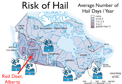
Although hail is less frequent in Canada than in the USA, significant hail falls are found in Alberta between the cities of Calgary and Edmonton, particularly near the town of Red Deer. Hail is also found in central British Columbia, and in the southern prairies of Saskatchewan and Manitoba. Here is an interesting video of hail on the ground in Alberta: |
 |
| In the S. Hemisphere, hail falls often occur over eastern Australia. The 14 April 1999 hailstorm over Sydney caused an estimated AUS$ 2.2 billion in damage, the second largest weather-related damage total on record for Australia. Hailstorms have been observed over North and South America, Europe, Australia, Asia, and Africa. | |
How does hail affect aircraft?
Hail is EXTREMELY dangerous to aircraft. If hail breaks the windscreen, then the unfortunate pilot would be battered by rain, hail, extremely strong winds associated with the speed of the aircraft through the air, extreme wind chill, etc. Also, as hail dents the leading edges of the wings and tail, the aircraft would become extremely un-aerodynamic (increase in drag wind resistance, and decrease in lift by the wings), so the aircraft would need to be flown faster than normal to prevent it from falling out of the sky.Sometimes, hail is carried up into the anvil of a thunderstorm by the strong updrafts and then blown sidewise (horizontally) in the anvil away from the main updraft/downdraft core of the thunderstorm. But hail is heavy and starts falling immediately from the anvil. However it is now falling several kilometers away from (outside of) the visible thunderstorm cloud core. This is one of the reasons why pilots are recommended to stay 20 nautical miles or more away from a thunderstorm.
Here are some YouTube videos showing hail damage to aircraft:
- https://www.youtube.com/watch?v=SLINrBScW8E
- https://www.youtube.com/watch?v=__quQucmexw
- https://www.youtube.com/watch?v=4YMuMh-WRW0
Sadly, hail can also damage your aircraft while it is parked, if a strong thunderstorm moves over the airport. When I would land at an airport where thunderstorms were forecast for later that day, I would pay extra to have the plane towed into a hangar for safety. The hangar cost is much less expensive than paying to repair hail-damaged skin and windows on your aircraft.
Extra info for experts; not needed for this course.
- Stull, 2017: Practical Meteorology. Chapter 15 .
Key words: bounded weak echo region (BWER), giant hail, graupel, hail, hail shaft, hail swath, hailstone, terminal fall velocity, supercell, TORRO scale
Image credits. All figures by Roland Stull, except where otherwise noted.