ATSC 113 Weather for Sailing, Flying & Snow Sports
Weather Systems & Special Features
Learning Goal 9f: Describe the characteristics of extratropical cyclones, atmospheric rivers, sting jets, squall lines, waterspouts, and downbursts.
Extratropical Cyclones
Extratropical cyclones are cyclones that form outside of the tropics. They form in
mid-latitude zones, typically between 30o and 60o
latitude. These Low-pressure Centers, or "Lows", are blown by the prevailing global-scale westerlies
from west to east (and they often also move poleward at the same time).
In winter they form every 1 to 4 days and are blown across the North
Pacific Ocean and continue across Canada and then across the North
Atlantic Ocean. Similar Lows blow from west to east in Southern
Hemisphere mid latitudes.
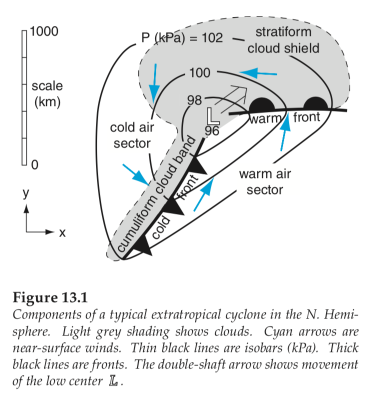
In Learning Goal 9b we saw how Lows are formed at the bottom of the atmosphere. Mid-latitude Lows have cold cores and fronts (see Figure below), while hurricanes have warm cores but do not have fronts.
Evolution
While lows are moving, they are also evolving, as shown in the figure below. New lows are formed (a process called cyclogenesis), then they strengthen, and finally they occlude as they weaken and die (a process called cyclolysis).
An occlusion is when the cold front catches up to the warm front,
creating an occluded front that has weather conditions of both warm and
cold fronts.
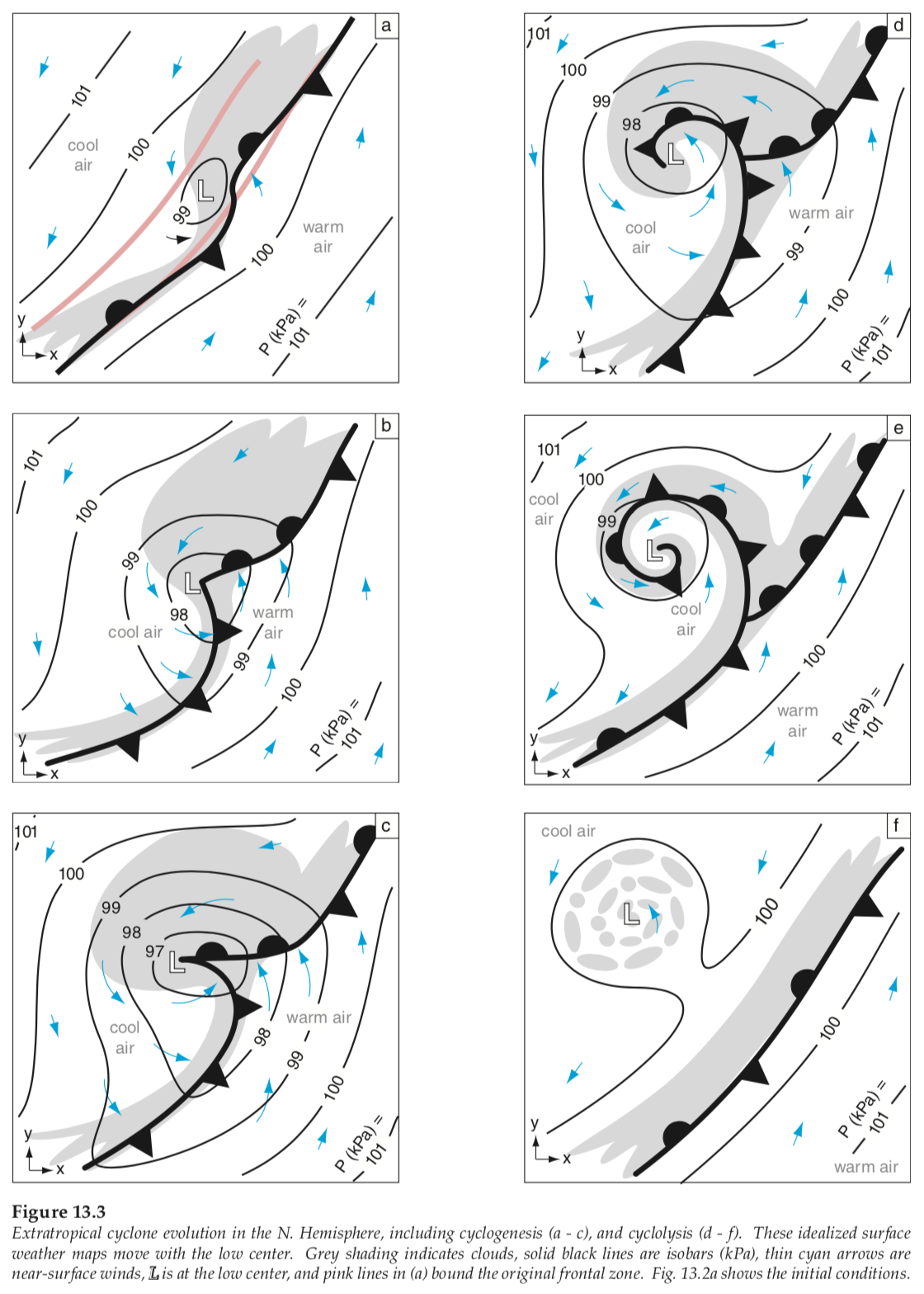
Source: R. Stull, 2017: Practical Meteorology. Used with permission.
We have already discussed lows and fronts extensively in this course, because Lows are centers of bad weather, with surface winds circulating counterclockwise around them. Flying Learning Goal 3h has a thorough discussion of lows and fronts. For Snow Sports applications, Lows were further described in Goals 5d and 5m, and Frontal weather was described in Learning goals 5f - 5h. Additional info on Fronts and frontal weather and clouds were introduced in flying Learning Goals 1a and 2e (Synoptic-scale wind shear).
Many Scales of Weather
Weather has many sizes (horizontal scales) superimposed on each other. Often the larger size features have weaker winds.
Large (planetary) scale: For example, in the figure below, the dashed yellow line represents the circulation around the large-scale Hawaiian High that spans the whole North Pacific Ocean (10,000 km in diameter). This is a weak, but persistant circulation that helps to steer typhoons (tropical cyclones) and Lows (extratropical cyclones).
Medium-large (synoptic) scale: Typhoons ( )
and Lows (L) have stronger winds, but are smaller in diameter (100 -
2,000 km). High-pressure centers are also synoptic scale, even
though they have weak winds and fair weather. Winds around these
synoptic systems are shown with the black curved arrows.
)
and Lows (L) have stronger winds, but are smaller in diameter (100 -
2,000 km). High-pressure centers are also synoptic scale, even
though they have weak winds and fair weather. Winds around these
synoptic systems are shown with the black curved arrows.
Medium (mesoscale): The width of frontal zones, particularly cold fronts, is of order 10 - 100 km in diameter. For extratropical cyclones, this is where the strongest winds are.
Medium-small: Embedded in cold fronts are thunderstorms (as suggested by the red stars in the figure below). These have even stronger winds (horizontal and vertical), but are roughly 8 - 15 km in diameter. Thunderstorms are also in typhoons and hurricanes (not sketched in the figure below).
Small-scale: Much
of the turbulence we have discussed in the flying modules are at the
small scale (0.01 - 3 km). Tornado and downburst diameters are
also in this range, and these features have extremely strong winds.
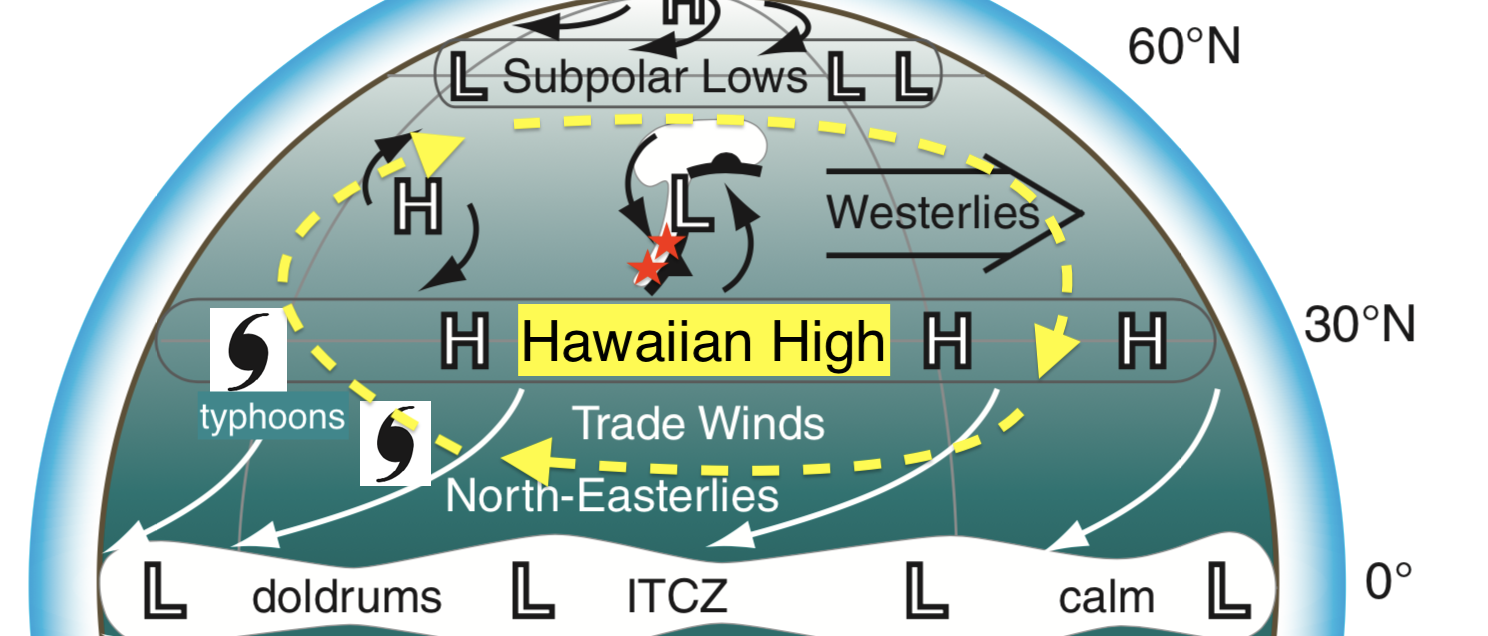
Sketch of the Northern Hemisphere over the
Pacific Ocean. Shown are global-scale circulations: trade winds
(white arrows), westerlies (black double-line arrow), Hawaiian High
(yellow dashed arrows). Also shown in mid-latitudes are
synoptic-scale highs (H) and lows (L) and their associated fronts and
winds. In low latitudes are typhoons. Adapted from R. Stull, 2017:
Practical Meteorology.
These scales are relevant to sailors because at any instant in time,
the weather you face can be a combination of many of these
scales. Also, the features of these scales (e.g., fronts, lows,
hurricanes) are continuously shifting and moving. That is why it
is extremely important for sailors to look at current weather maps to
see the actual conditions, and to look at forecasts to see an
approximation of how all of these weather features will move and evolve
in the future.
We will return to "scales of weather" in the last theme of this course: Applied Meteorology.
Lows vs. British Columbia
For British Columbia, most of our Lows come from the west, over the Pacific Ocean enroute to the BC coast. Many of these lows form over the warm waters of the Kuroshio current in the western Pacific. As the lows move across the Pacific they reach maximum strength at about the date line (180 degree longitude), and begin to occlude and die as they approach the Gulf of Alaska and British Columbia. This brings widespread overcast clouds and drizzle during winter to the west coast of British Columbia. Typical evolution of these lows is shown in the figure below.
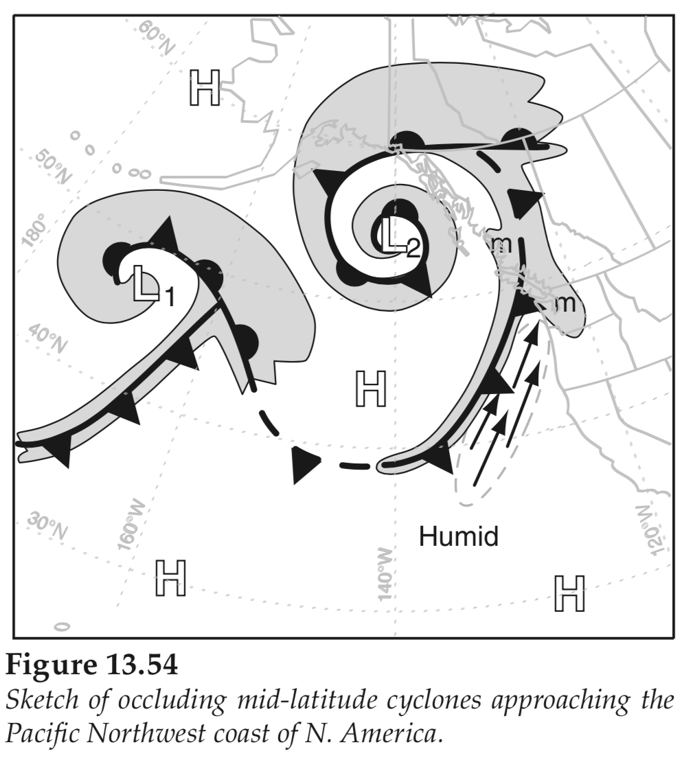
Fronts are indicated in black. Clouds
are shaded grey. The atmospheric river of fast humid winds are
shown with the arrows. L = low-pressure center. H =
high-pressure center. Adapted from R. Stull, 2017: Practical
Meteorology.
Low L1 in the figure above has just started to occlude south of the Aleutian Islands of Alaska, while low L2 is well occluded, as indicated by the spiral band of clouds around the low center in the Gulf of Alsaka. In this sketch, the arrows that are circled by the dashed line indicate an Atmospheric River, in which lots of humid air streams rapidly toward the mountains (m) of British Columbia. This causes extensive heavy rain and flooding.
Sting Jets
Sting jets are a rare phenomenon that can be produced by specific type of extratropical cyclone in which the warm and cold fronts never meet. The sting jet forms as strong winds start to descend towards the ground, drying and evaporating as they fall, allowing them to become denser and faster just east of the Low center. The sting jet strikes a relatively small area on the ground (shaded green in the first figure below), but leaves immense devastation in its wake.
The first great sting jet observed was during the Great Storm of 1987 in southern England. It was because of the damage caused by this storm that scientists started looking into this phenomenon. Below is a sketch, and a satellite photo, of a sting jet. Sting jets can cause extremely dangerous winds for sailors.
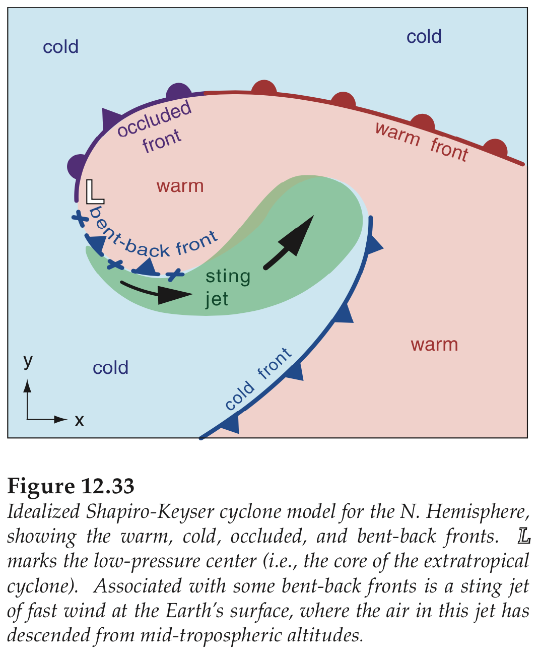
Adapted from R. Stull, 2017: Practical Meteorology.
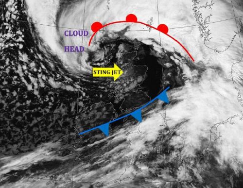
Satellite image of a Sting Jet hitting northern UK. Source: www.weatherclub.co.uk
Squall Lines
A squall line is a long chain of
thunderstorms that forms along, or ahead of, a cold front.
Although they can be long (1000s of km), they are not often very wide (10 - 15 km). They produce
heavy rain, thunder and lightning.
These squall lines are a major hazard to sailors. In addition to dangerous lightning, strong gusty winds, downbursts, and tornadoes/waterspouts, these lines advance very quickly across the water.
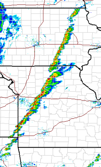
The first image below is a composite of weather radar returns from across
the USA. The squall line is the narrow band of red colour
(indicating very heavy rain in thunderstorms) from Iowa to Texas.
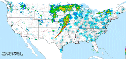
Source: National Weather Service - http://radar.weather.gov/Conus/Loop/NatLoop.gif, Public Domain, https://commons.wikimedia.org/w/index.php?curid=4171245
The next image is a closer view of a more-recent squall line, in
roughly the same part of the USA. Again, this composite image
from many radars shows the squall line as a narrow, but long line of
thunderstorms with heavy rain (the red color in this image).
Although these two squall-line images are over land, similar
squall-lines of hazardous weather can occur over the ocean, but too far
away to be seen by land-based weather radars.
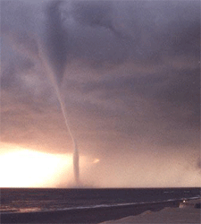
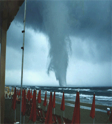
Waterspouts
A waterspout is a spiralling column
of air and cloud droplets and sea-spray that develops over water
beneath a cumuliform or cumulonimbus cloud. (A waterspout is mostly
air, made visible by the tiny water droplets carried by the air.
A waterspout is NOT a column of water being sucked up from the ocean.)
There
are two types of waterspouts: tornadic and fair weather.
Tornadic
waterspouts tend to start as tornadoes overland and then migrate out to
sea, or form over the sea in the same way as land tornadoes do (namely,
formed by supercell thunderstorms). Waterspouts typically form
from the thunderstorm clouds downward. They are associated with
thunderstorms and
severe weather.
Fair weather waterspouts are more common. They start to
form on the water’s surface and work their way up towards the clouds.
They start as a dark patch on the water’s surface that begins to
spiral. Then a ring of spray will start to pick up around the dark
patch of water
and gradually start to rise and take on the shape of a cylinder.
Nonetheless, the fast and shifting winds near the bottom of fair
weather waterspouts can capsize sailboats.
Tornadic waterspouts can cause severe damage to boats and you should keep your distance if you see one forming.
Downbursts
A downburst is a rapidly descending
column of air that hits the earth or ocean surface and radiates rapidly
outwards, as sketched below. When the downburst air hits the ground,
the air spreads out in straight lines away from the downburst. Downbursts form during thunderstorms. They tend to be
relatively small in area, in which case they are known as microbursts,
however larger macrobursts can also occur. They produce straight-line
winds, which are very powerful and can cause significant
damage and can easily capsize sailboats. See more downburst info from Flying-weather learning goal 4b(d).
It is believed that a microburst hit and sank the SV Concordia, a training vessel for students, when it was sailing off the coast of Brazil. In 15 seconds, the 57-meter vessel had capsized onto its side before sinking twenty minutes later (see news article in ‘Additional Resources’ below).
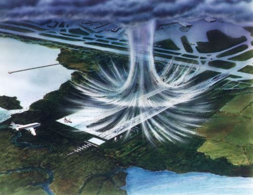
Source: Public Domain, https://commons.wikimedia.org/w/index.php?curid=2562378
Additional Resources: (non-required material)
Wikipedia – Extratropical Cyclone: https://en.wikipedia.org/wiki/Extratropical_cyclone
Sting Jet Newspaper Article: https://www.theguardian.com/uk/2012/oct/16/sting-jets-hurricane-michael-fish
Microburst sank Canadian sailing-school ship, meteorologist says: http://www.theglobeandmail.com/news/national/microburst-sank-canadian-sailing-school-ship-meteorologist-says/article1366514/
Video: (non-required material)
What not to do. Man goes into waterspout off Florida coast: http://www.telegraph.co.uk/news/worldnews/northamerica/usa/10340008/Man-sails-into-centre-of-waterspout-off-Florida-coast.html
Keywords: extratropical cyclone, cyclone, low,
cyclogenesis, cyclolysis, occlusion, atmospheric river, front,
westerlies, sting jet, warm front, cold front, squall
line, waterspout, downburst, planetary scale, synoptic scale, mesoscale
Image credits: are given near the images.