| |
|
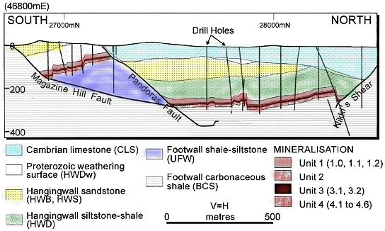
The Century deposit is located approximately 250 km NNW of Mt. Isa in NW Queensland, Australia. The deposit is hosted by relatively flat-lying middle Proterozoic siltstone and shale units. Mineralization occurs preferentially within black shale units as fine-grained sphalerite and galena with minor pyrite. Structures and geology were well constrained based on this project's drilling program, under the direction of CRA Exploration Pty. Ltd.
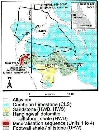
A geologic sketch of the deposit area is shown below, along with an example of physical property logs acquired in a drill hole. Line 46800E is labelled, and the geologic cross section under this line is also shown. |
 |
| |

Resistivity and IP log for drill hole LH117. The geology column uses the key shown under the sketch map. |
Physical properties
There is a summary of geophysical characteristics of this deposit in Thomas et al (1992). The deposit discovery was based on a zinc geochemical anomaly. Extensive geophysical work was carried out at all phases of exploration with mixed success. Density and susceptibility variations were not significant enough to cause useful gravity or magnetic anomalies that were associated with ore. Electrical conductivity contrasts were slight, resulting in little response from ground-based electromagnetic data and airborne electromagnetic (GEOTEM) surveys. In particular, conductivity response of the sulfides was likely masked by the response due to conductive shales and siltstones, which host the mineralization.
However, induced polarization surveys were successful at imaging the ore body, and DC resistivity data were able to delineate overburden and structural information. The table below summarizes the electrical properties of the geological units. It is based on borehole logs and analysis of core and outcrop samples. One such log is shown in the figure above.
| Geological Unit |
Resistivity in Ohm-m |
Chargeability |
| Cambrian limestone (overburden in many locations) |
> 1000 |
minimal |
| Hanging wall sandstone, siltstone and shale |
60 - 75 |
minimal |
| Foot wall siltstone and shale |
80 |
moderate |
| Ore (fine-grained sphalerite and galena, with minor pyrite, within black shale units). |
100 - 300 |
moderate |
Both time domain and frequency domain IP surveys were carried out. Comparison showed that both models delineated the ore body and afforded good estimates of the extent and depth of mineralization. However, frequency domain results provided better definition of anomalies because of the higher power and greater signal-to-noise ratio. There was also reason to suggest that discrimination of Century mineralization might be possible using complex resistivity techniques.
Contributions of inversion results
The inversions discussed in this case history used frequency domain data from line 47000E as input. Inversion results assisted in defining the limits of mineralization and mapping lithological boundaries both laterally and in terms of depth. It should be clear upon comparison of pseudosection results and inverted models that such detailed information on locations of geological materials is greatly enhanced by performing 2D inversions of resistivity/IP profiling surveys. The inversion work was done after publication of the Thomas et al paper, so results did not contribute to that paper. However, see Mutton, 2000 for discussions on how geophysics contributed to characterization of this deposit both early and late in the exploration process.
Raw resistivity and induced polarization data from line 47000E are discussed in the survey and pre-processing sections. Geological faults and the extent of the ore body are presented as overlays on figures showing resistivity and chargeability structures recovered using inversion methods. These results are discussed in the inversion and interpretation sections.
 home © UBC-GIF
January 9, 2007 home © UBC-GIF
January 9, 2007
|
|
|
|
|