|
Seismic refraction examples |
|
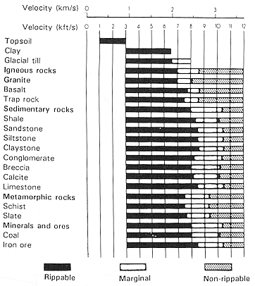
Here are three short examples of seismic refraction applied to engineering-scale problems. Velocity as a guide to rock strength(From P.V.Sharma, 1997, Environmental and engineering geophysics, Cambridge University Press, p175)
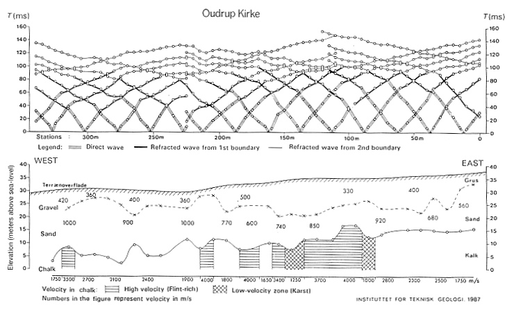
Mapping Sand and Gravel Deposits(From P.V.Sharma, 1997, Environmental and engineering geophysics, Cambridge University Press, p180-182) Delineation of sand and gravel deposits is of special importance in connection with the planning of quarrying operations at potential exploitation sites. These deposits, when located above the water table, are characterized by low velocities in the range 400 -1000 m/s, in contrast to water-saturated sand and moraine which typically have velocities in the range 1300 - 2000 m/s. The following example is from Denmark. The seismic refraction profile in an area of Quaternary sedimentary deposits Ourdrup Kirke, Denmark is shown below. Interpretation of the travel time curves indicated the first layer (gravel) with velocity varying from 330 - 500 m/s, the second layer (sand) of velocity between 560 and 1000 m/s, and the third layer (water-saturated chalk) of velocity 1650 - 2800 m/s. The lower layer also included a few isolated zones of high velocity (3400 - 4000) m/s as well as zones of low velocity (1000 - 1250) m/s. The interbed thickness of the gravel deposit varies from 5 m to 14 m and the combined thickness of the gravel and sand is about 25 m. Interpretations of velocities and depths were made using the
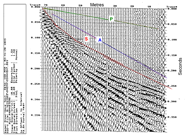
Shear wave refractionThis record was recorded using geophones mounted horizontally and transverse to the profile. To generate the shear wave signal a metal bar with fins to anchor it to the ground was placed transverse to the profile, then struck with a hammer on either end. Records from these two shots were subtracted so as to increase signal-to-noise ratio. Aprominent air wave (A) can be seen, followed by a horizontally polarized shear wave (S). High amplited late arrivals are surface waves or ground roll. S-wave refractions were used to identify the structure of glacial till below the shallow water table. Shear waves are useful here because the water table refraction is nearly invisible because the water does not contribute to shear wave velocity. When P-waves were recorded at this site, the refraction at the top of the water table was the dominant feature because of the significant velocity contrast at the top of the water table. Glacial till structure was therefore easier to interpret from shear wave data than from P-wave data.
|