|
Permafrost mapping
|
| On this page we describe data processing for each of the surveys. As for many engineering and environmental projects, rapid turn-around of results was paramount, so processing of geophysical results was kept to a minimum. EM-34 and GPR results were used with minimal processing; inversion of resistivity profiles will be described on the next page; and interpretations of all three results are on the interpretation page. Apparent conductivity mappingResults are generally presented as profiles of apparent conductivity versus line position, or as contour maps if lines are close together. In this case, data were recorded by hand into field note books, and results were entered into a spreadsheet for plotting after the survey. Interpretations were made directly from graphs of apparent conductivity versus line position. The important thing to remember is that the data represent apparent conductivity. This is not the true conductivity of ground, unless the subsurface has no variation within range of the instrument. For the EM-34, operated at 20 metres in the horizontal dipole mode, depth of investigation is around 15 metres in frozen ground, and somewhat less in conductive ground. Variations in resistivity at scales less than 15 metres will be averaged for each measurement. Apparent conductivity profile is presented here, but interpretation is deferred until later. 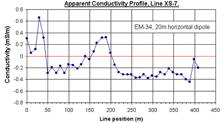
Electrical imagingWhen resistivity profiles are gathered using Schlumberger, Wenner and dipole-dipole arrays, each measurement is an apparent resistivity. Information from a range of depths is obtained by using a range of electrode separations. Larger electrode spacing results in an apparent resistivity that involves a larger (and deeper) volume of ground, but spacial resolution is correspondingly broader. When a large number of readings at a wide range of spacings are gathered along a survey line, the conventional method for plotting results is to generate a pseudosection. There is no special processing needed to prepare data for plotting as pseudosections, except to reduce recorded currents and voltages into correct apparent resistivities by accounting for the geometry of the electrodes. The raw pseudosection generated by commercial software in the field is reproduced below. On this plot, the vertical axis is labelled as a pseudo-depth, "Ps.Z." These approximate depths are calculated assuming a uniform earth, and in the absence of formal inversion, to provide a first order estimate for locations of anomalous material. 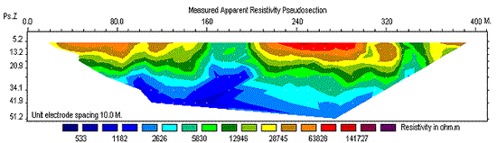

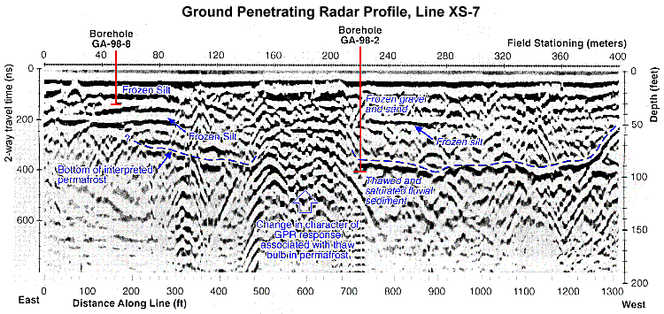
Ground penetrating radar (GPR)GPR data are gathered as one echo-sounding trace at each location. The standard display involves plotting traces side-by-side to provide a profile with line position along the horizontal axis, and two-way travel time of echoes along the vertical axis. Echo strength is depicted either as a shaded wiggle (like a seismic trace), or as a range of colour density. Speciallized software is required to handle GPR data, but there is little processing involved. A gain function may be applied to enhance weaker arrivals from later times, or to suppress the early very strong signals. If a depth scale is required (in addition to the time scale), some estimate of the velocity of EM waves in the ground must be made. In simple situations, it may be adequate to obtain a representative velocity from tables of material properties. Usually, it is better to perform a secondary survey known as a Common Mid Point (CMP) (also known as a WARR or wide angle reflection and refraction) survey. GPR data gathered along the same line as the EM-34 data are shown below with annotations showing interpretations. Details are discussed on the interpretation page.
|