Summary
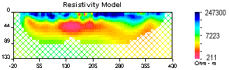
Three different geophysical surveys were performed to help map the distribution and depth extent of discontinuous permafrost and to help provide depth constraints to bedrock under river sediments. Ground penetrating radar (GPR), 2D resistivity profiling (electrical imaging), and frequency domain electromagnetic (FDEM) mapping of apparent conductivity were all performed along the same six survey lines. Shallow boreholes helped calibrate and verify results.
The purpose of presenting this case history is to illustrate two important ways of ehnancing the information provided by geophysical surveys. Effective interpretations are ensured first by using several complimentary data sets, and second by inverting 2D resistivity profiles to obtain models of subsurface resistivity structure. Results from one line are used as an example.
| © UBC-GIF
January 9, 2007
|
|
|
|