After the soundings were acquired in the field, data were shipped to Placer Dome in Vancouver by satellite where they were inverted using the 1D inversion algorithm of Farquharson and Oldenburg, 1993. In carrying out the inversion, the earth model was divided into 30 layers of successively increasing thickness and mi = log si (where si is conductivity of the ith layer) was used as the model parameter. The model objective function was designed to penalize structure in the vertical direction. In other words, input parameters were specified so that the inversion algorithm searched for a model that was both as smooth as possible and capable of producing a predicted data set that matched observations to a specified degree of misfit. Gaussian errors varying from 1% for the earliest time channel to 20% for the latest time channel were assigned to the data. The problem is non-linear and is solved iteratively.
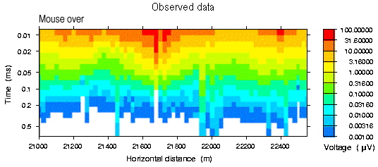
Observed data (as shown in the survey section). Move your mouse over the image to see predicted data resulting from the recovered smoothest model. Interpretation is discussed on the interpretation page.
| © UBC-GIF
January 9, 2007
|
|
|
