Background
Introduction
The accreted Wrangellia oceanic plateau in the Pacific Northwest of North America is perhaps the most extensive accreted remnant of an oceanic plateau in the world where parts of the entire volcanic stratigraphy are exposed.
Wrangellia flood basalts formed as an oceanic variety of a large igneous province (LIP) in the Middle to Late Triassic, with accretion to western North America occurring in the Late Jurassic or Early Cretaceous (e.g. Richards et al., 1991).
Wrangellia flood basalts form the core of the Wrangellia terrane, or Wrangellia, one of the largest outboard terranes accreted to western North America (Jones et al., 1977).
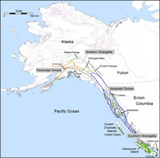
Current exposures of the flood basalts are preserved in a narrow belt over 2300 km in length extending from southern British Columbia (BC) through Yukon and into Alaska (Fig. 1).
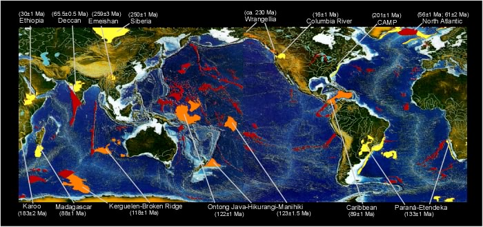
There are approximately 10 oceanic plateaus that have formed in the last 130 Myr, ranging in size from 100,000 to 2 million km2, and collectively they cover an area of about 10 million km2 (~3%) of the ocean basins, mostly in the Pacific and Indian oceans (Fig. 2; e.g. Eldholm & Coffin, 2000).

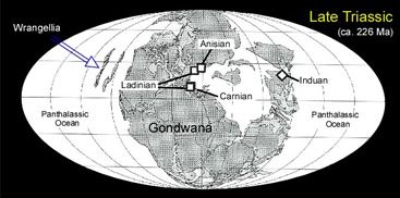
The Wrangellia oceanic plateau formed mostly within the Late Ladinian and Carnian stages of the Triassic Period (ca. 231-225 Ma; e.g. Carlisle & Suzuki, 1974; Parrish & McNicoll, 1992), as the continents were gathered into a great landmass.
The Wrangellia flood basalts erupted onto different-aged Paleozoic arc volcanic and marine sedimentary sequences in both shallow and deep marine settings.
Paleontological and paleomagnetic studies indicate that the Wrangellia flood basalts probably erupted in the eastern Panthalassic Ocean in equatorial latitudes
(Fig. 3; Jones et al., 1977; Katvala & Henderson, 2002).
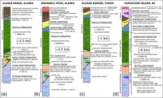
Much of the original stratigraphic thickness of the Wrangellia plateau is intact and is defined as the Karmutsen Formation on Vancouver and Queen Charlotte Islands (Haida Gwaii), and as the Nikolai Formation in southwest Yukon and south-central Alaska (Fig. 4).
In the 1970s, Jones and co-workers (1977) defined a terrane of fault-bound blocks of crust that contain diagnostic Triassic flood basalts in BC, Yukon, and Alaska as Wrangellia, named after the type section in the Wrangell Mountains of Alaska .
A back-arc setting was initially proposed for the formation of Karmutsen basalts on Vancouver and Queen Charlotte Islands based on major- and trace-element geochemistry of 12 samples (Barker et al., 1989).
Ongoing research on the Wrangellia oceanic plateau
Wrangellia flood basalts formed in submarine and subaerial environments in the Middle to Late Triassic during a single, short-lived eruptive phase that probably lasted less than 5 Myr.
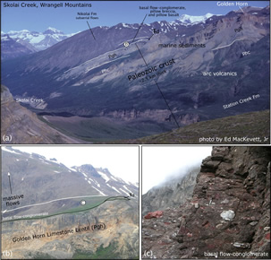
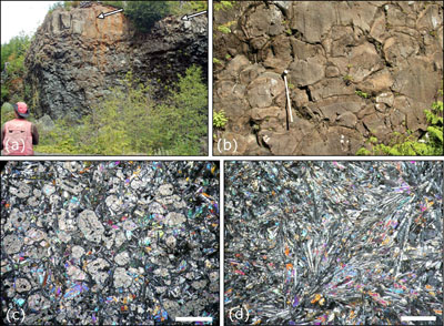
Volcanic stratigraphy in Alaska and Yukon (Nikolai Formation) was initially emplaced in a shallow marine environment, but the majority of the volcanic stratigraphy formed as compound pahoehoe flow fields in a subaerial environment, in a similar way to subaerial flows in CFBs (Fig. 7 and Fig. 8).
In contrast, the Wrangellia flood basalts on Vancouver Island (Karmutsen Formation) grew from the ocean floor and accumulated >3000 m of pillowed and massive submarine flows before emplacement of 400-1500 m of hyaloclastite and pillow breccia as the plateau formed in shallow water and reached sea level (Fig. 9 and Fig. 10).
The lowest pillowed flows were emplaced on unconsolidated and lithified fine-grained siliciclastic and carbonaceous sediments containing Daonella beds (ca. 235-232 Ma) that are intruded by abundant Karmutsen mafic sills.
Minor volumes of picritic pillow lavas occur in the upper part of the pillowed flow sequence in areas of the plateau exposed on northern Vancouver Island (Nixon et al., 2008).
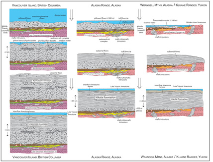
On Vancouver Island, approximately 1500 m of subaerial flows were emplaced on top of the submarine flows and intervolcanic sedimentary lenses in the upper parts of the subaerial stratigraphy formed in shallow water as eruptions waned and the plateau was subsiding.
After volcanism ceased, for areas of accreted stratigraphy in Alaska, Yukon, and British Columbia, the plateau continued to subside for more than 25 Myr and was overlain by hundreds to >1000 m of limestone and siliciclastic deposits.
Publications
See the publication page for links to more in-depth descriptions of ongoing studies.


LIP of the MonthSee the Large Igneous Provinces Commission