ATSC 113 Weather for Sailing, Flying & Snow Sports
Wind Shear at Aerodromes (Airports)
Learning Goal 2e. Identify the causes and typical locations of wind shear at aerodromes
Definition: "Aerodrome" is another name for an airport.What is Wind Shear
Wind shear is the change of wind speed
and/or wind direction with altitude. Wind shear can happen at any
altitude. Wind shear is almost always present near the ground
(except when the winds are calm), and the shear is stronger when the
near-surface wind speeds are faster.
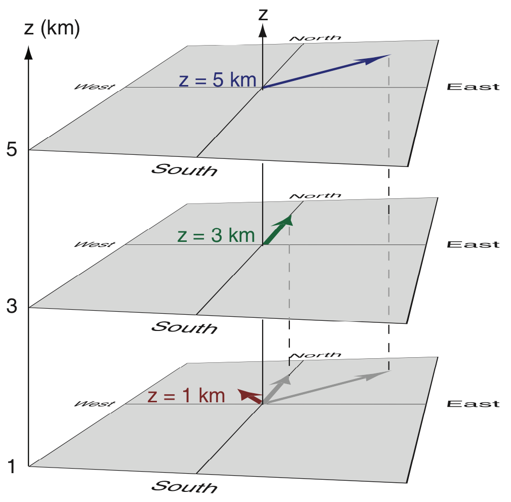
In the figure below, the darker coloured arrows represent the winds at different altitudes (z), where longer arrows mean faster winds, and where the direction the arrow is pointing show the direction of wind flow. The "shadows" of all the wind vectors are shown at the bottom in grey colours, so you can more easily compare their different lengths and directions.
Note that wind direction is where the wind comes FROM. For example, in this figure, the wind at z = 1 km altitude (dark red arrow) is from the southeast, so it is called a "southeast wind" (from 135° compass direction).
Aside: Wind Direction and Runway Direction (copied from learning goal 2d)
Aircraft try to land and takeoff into the wind (i.e., a headwind) because they don't need so much runway length.
Runways are labeled by the magnetic compass direction toward which aircraft are pointed when on (or approaching) the runway (see example below). For example, if there is a runway oriented toward the southeast, then the approach end (the end of the runway first encountered by landing aircraft) is labeled by that direction (rounded to the nearest tens of degrees). So a runway pointing toward the southeast would have the numbers 14 written on it (14 means 140 degrees, which is 135 degrees rounded to the nearest ten degrees).
Bottom line: pilots try to land and take off on a runway that has a number closest to the wind direction number (rounded to nearest 10 degrees) because that gives the best headwind.
Solved Example: In the figure below, if aircraft are approaching runway 30 to land at CYVR Airport, then: (a) What direction is the aircraft flying (what is its ground course)? (b) What is the wind direction if the wind is straight down the runway?
Answer: (a) An aircraft flying toward CYVR from the southeast to land on runway 30 would be flying on a course of 300°; namely flying TOWARD the northwest. (b) The wind would be FROM 300°; namely, from the northwest toward the southeast.
Discussion: In this particular example with the wind straight down the runway, the aircraft heading would also be 300° while landing.
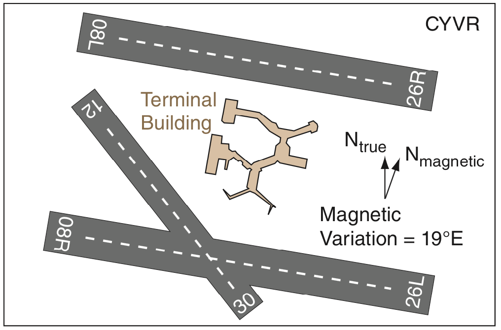
Sketch of the runways at Vancouver International Airport (CYVR). When two runways are parallel to each other, they are labeled with R or L for right or left.
Wind shear occurs almost everywhere all the time in the atmosphere. However, strong wind shear near the ground at airports makes it difficult to land and take off. Strong wind shear near the ground can create strong turbulence, so sometimes both turbulence and wind shear are grouped together under the category of wind shear.
What Causes Wind Shear
There are many ways that hazardous wind shear and the associated
turbulence occur at airports. Although all are listed here for
completeness, some are covered under other Learning Goals (LG).
But for topics 1a, 2b and 2c below, please click on the links here to see the details.
- Caused by weather systems:
- Synoptic-scale shear (associated with low-pressure centers, fronts, and strong surface winds)
- Convective shear caused by thunderstorm downbursts,
microbursts, and gust fronts. See Learning Goal 3h.
- Caused by wind flowing across mountains
- Mountain-wave shear (including rotors) downwind of mountains. See Learning Goals 3c and 1b.
- Channeling of winds through valleys and mountain passes (gap winds)
- Mountain downslope
windstorms, including chinooks (Foehn) and boras
- Associated with turbulence behind obstacles (trees, buildings,
mountains). See Learning Goal 3f.
- Caused by other large aircraft and helicoptors that are landing and taking off (not discussed here).
Some other factors create weak wind shears that are not a hazard to aircraft. These are often local winds that occur only when the large-scale winds are weak, such as in a high-pressure regions. Examples of these local winds with weak wind shears are thermals of warm air that rise over hot surfaces, sea breeze (or lake breeze) during the day near coast lines, land breeze at night near coast lines, anabatic winds (warm air moving up along mountain slopes that are warmed by the sun during daytime), and katabatic winds (cold air draining down mountain slopes into valleys at nighttime as the mountain slopes cool).
Although katabatic winds are weak in most parts of the world, they can become very fast (causing dangerous wind shear) in Antarctica where there are very long downhill slopes from the cold ice cap toward the oceans. Similar dangerous regions include very long long glaciers or very long downward sloping snow fields.
More resources; Search YouTube for wind shear:
- FAA YouTube video "A Windshear Avoided". Retro, but thorough. Designed for pilots, but non-pilots might find it interesting.
- YouTube video of "Windshear at 300 ft ... Boeing 737". View from the cockpit while approaching an airport.
Key words: wind shear, sea breeze, lake breeze,
land breeze, anabatic winds, katabatic winds, aerodrome, synoptic scale
Extra info for experts; not needed for this course.
- Transport Canada AIM - AIR section 2.8 on Wind Shear.
- FAA AIM section on Wind Shear. Sections 7-1-24 and 7-1-26.
- FAA Wind Shear publication.
- FAA Advisory Circular AC 00-54 - Pilot Windshear Guide.
- YouTube: Windshear. An airline captain discusses how you fly in windshear.
- YouTube: Turkish Airlines Airbus 320 Windshear After Rotation.
- YouTube: Heavy Turbulence and Wind Shear in a Diamond DA 40.
Image credits. All the photos were taken by Roland Stull, and the drawings were made by Roland Stull, and all are copyright by him and used with his permission.