ATSC 113 Weather for Sailing, Flying & Snow Sports
Warm Front Weather Conditions
Learning goal 5h. List the weather conditions associated with a warm front and their relevance to snow sports.
Fronts are responsible for much of the sensible weather we experience (precipitation, clouds, winds, temperature changes). Therefore they are important to your day in the mountains where you are directly exposed to these effects. To remind you, a warm front indicates the boundary between a warmer and a cooler air mass, where the warm air is advancing (introductory info in Flying Learning Goal 3h).
In general, warm fronts present fewer hazards than cold fronts in terms of winter weather conditions, but they are certainly not without hazards.
Temperature trends
In the mountains, warm fronts can often present marginal conditions where the temperature is close to 0°C. Around this temperature the precipitation type can change from snow to rain, vice versa, or give you a mixture of the two, and can also melt and refreeze snow that is already on the ground. Temperature also changes the density of falling snow (discussed in Learning Goal 7b).
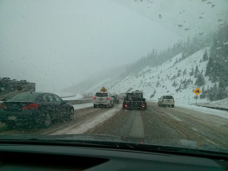
Fig. 5h.1 Marginal conditions while driving to the ski hill on I-80 in Colorado. The temperature is fluctuating above and below 0°C. (Credit: West).
As discussed in Learning Goal 5f, along a front within a frontal zone, there is a temperature gradient. In a warm front the warm air is advancing. That means that if you're experiencing a warm front passage you will experience warming temperatures. Temperature changes with a warm front are typically weaker than with a cold front both because the temperature gradient is weaker and because it's moving more slowly.
Winds
In the Northern Hemisphere midlatitudes, the winds ahead of a warm front typically come from an easterly direction. Behind the front, winds shift to be more southerly.
As with cold fronts, complex topography can change what the wind direction and speed would be without the terrain. The fastest wind speeds relative to a warm front will vary from storm to storm. Sometimes they peak ahead of the front, sometimes with the frontal passage, and sometimes after the front. Wind forecasting is covered in detail Learning Goals 5b, 5j, 5k, 6f, and 6g.
Precipitation, clouds, and visibility
Recall the vertical cross section of a warm front from the Flying Learning Goal 3h. As the warm front progresses, the warm air mass slowly rises up over the cooler air mass ahead of it. The vertical motion is generally slower and less turbulent than with a cold front. This means the clouds are more stratiform (uniform, slow to change, stratus-type clouds; see Fig. 5h.2), although some cumuliform clouds can occur.
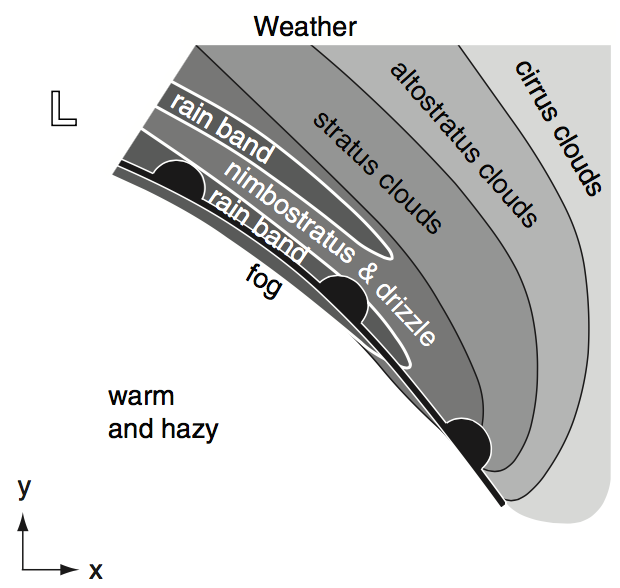
Fig. 5h.2 Typical weather (clouds and precipitation) associated with a warm front.
In the real world, this means that as a warm front approaches, the weather very gradually deteriorates. High clouds, sometimes starting with a few wisps of cirrus, become thicker, and gradually lower over several hours, or sometimes even a day or more. If you are on the ski hill, at some point flat light will likely become an issue. Flat light is when sunlight is strongly diffused which can make it difficult to see the texture of the snow surface. You may be caught off guard by a mogul, cornice, or cat track (the flat road that a snow grooming machine travels along). Eventually the cloud base will descend below mountaintop height. If the cloud descends to your level you will start to lose visibility due to fog (which is just a cloud that's at or below ground level at your location).
Likewise, the onset of precipitation is usually gradual. Precipitation begins ahead of the surface front, usually in the form of drizzle or light snow, and covering a large area. Due to the gradual temperature increase with the frontal passage, the precipitation may change characteristics (such as changing from snow to rain, or snow becoming wetter and more dense).
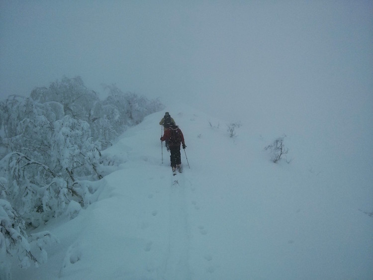
Fig. 5h.3 - Dense snowfall during a warm frontal passage. Tree branches sag under the weight of heavy snow and mixed snow/rain. Visibility is also limited by thick clouds. Mount Shiribetsu, Niseko, Japan. (Credit: West)
In Learning Goal 5g, we explain why it is hazardous to ski in bad visibility, particularly in the backcountry outside of patrolled ski areas. Warm fronts can also cause bad visibility in the mountains, but the causes differ slightly as follows:
-
Reduced visibility from blowing snow from the ground and/or air into your face
Strong winds are more commonly associated with cold fronts, however it is possible to get some wind gusts in the warm sector.
-
Thicker clouds and fog
Warm air can hold more moisture than cooler air, meaning clouds and fog associated with warm fronts are typically thicker and denser than those with cold fronts. Sometimes skiers refer to this as soupy conditions (Fig. 5h.4).
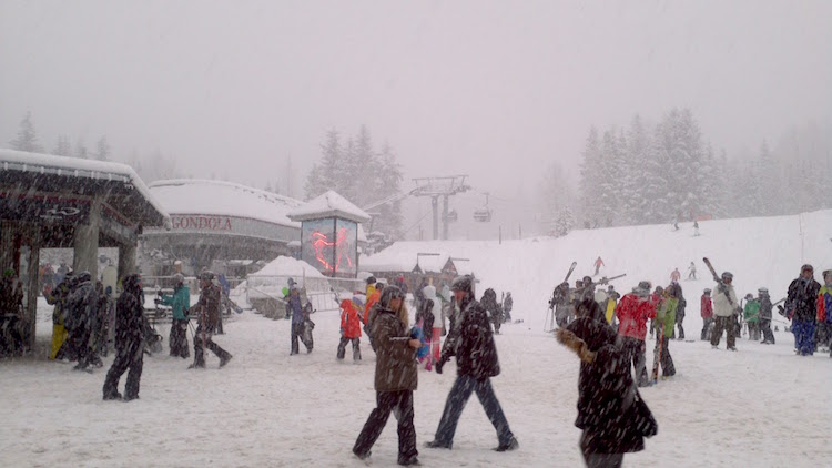
Fig. 5h.4 - Typical weather (clouds and mixed precipitation) associated with a warm front. Visibility is likely very poor above the base of the ski area. Whistler, BC. (Credit: West).
In extreme white out conditions, you can usually only see immediately in front of you. This has severe implications for safety. Navigation is obviously difficult or even impossible in the fog.
Storytime
One time when hiking by Mount Robson in the northern Canadian Rockies, my partner and I were on a trail that emerged from the trees into an open, featureless plain. There was snow on the ground, snow in the air, and visibility was limited by fog. We figured if we just walked in a roughly straight line, we should end up at the other side of the plain where the trail would continue. We walked for probably 20-30 minutes, thinking that the open area was much longer than we recalled. Eventually, we saw the trees and the trail and were relieved. However, upon getting to the opening in the trees, we realized that it was the opening we left from - right back where we started! We had walked in a giant circle. Two lessons: (1) You can't walk in a straight line for much of any distance if you can't see, so don't try, and (2) use a compass bearing and/or GPS to keep you on track in these situations. Take them out and practice using them before you get lost.
Another issue that can arise due to a lack of visibility is that your group can get separated. This can become a dangerous situation if a skier gets injured or lost, or if the party separates further or gets lost looking for each other. Lastly, you can't see mountain hazards without visibility. People have unfortunately walked off cliffs in bad visibility. More common is crevasse danger on glaciers. Even if you're following a GPS track that you made in good weather, trying to retrace it can be dangerous if you deviate a short distance from the path. It's often best in these situations to stay put and wait for the weather to improve.
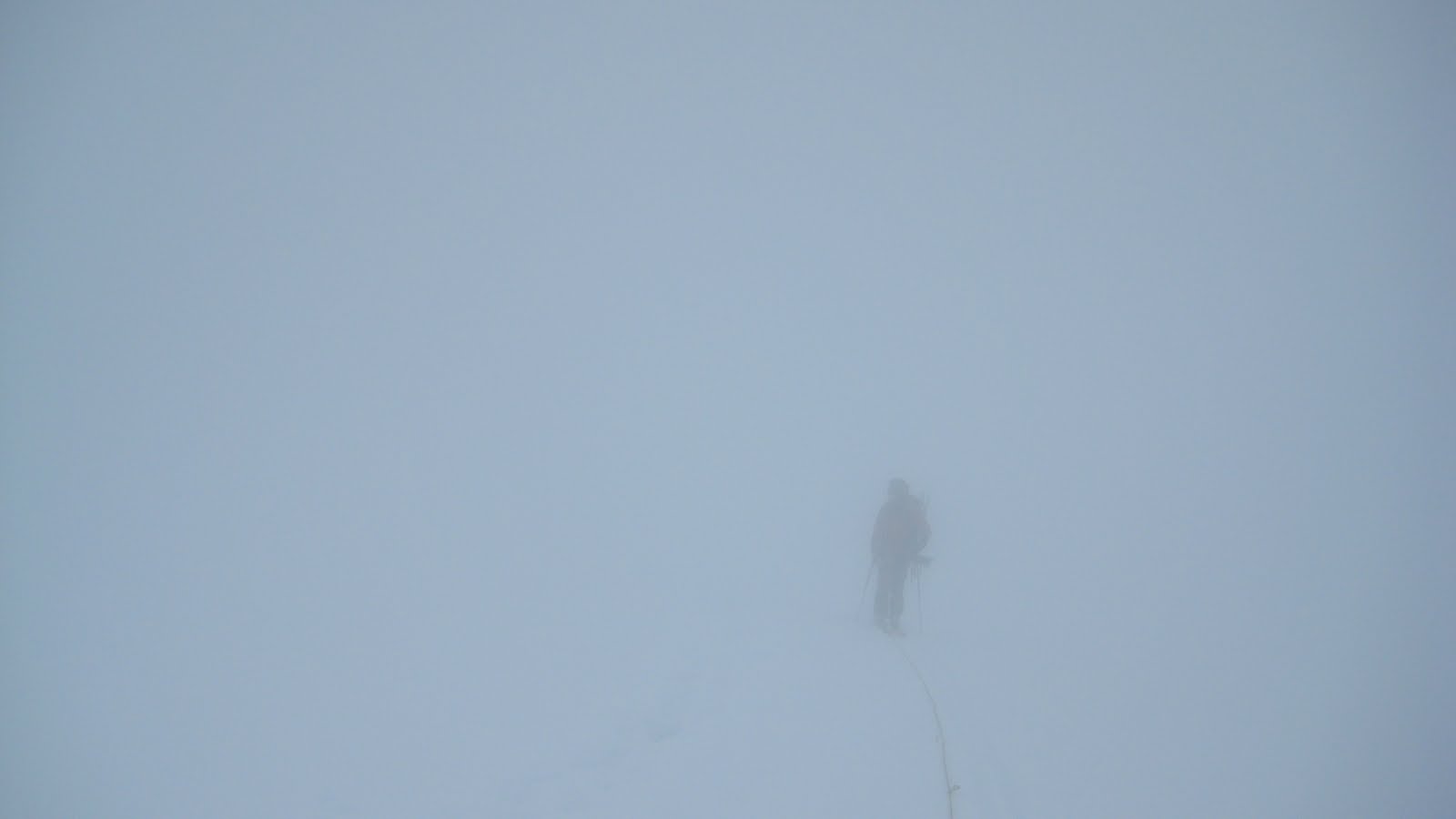
Fig. 5h.5 - Whiteout conditions on Mount Shuksan, WA, USA. The mountaineer in the picture is joined to the photographer by a rope for safety while on a glacier (with crevasse danger) in bad visibility. (Credit: West)
Finally, behind the warm front, some convective (less uniform, more rapidly changing) clouds and showers are possible due to weak instabilities within the warm air mass.
Key words: warm front, front, gradient frontal
zone, warm sector, stratiform, flat light, white out
Figure Credits: Howard: Rosie Howard, West: Greg West, Stull: Roland Stull