Under construction.
Learning Plan: We will do a forensic meteorological analysis of this fire. Namely, we will tie the known evolution of the fire with the known evolution of the weather. To do this, we will use satellite observations, surface weather analyses, and weather maps produced by numerical weather prediction (NWP). This approach will introduce you to synoptic and mesoscale weather forecasting.
| Date | Item | Topic | Assignment | Learning Goals. By the end of this section, you will be able to ... |
|---|---|---|---|---|
| Day 6: 19 Sep 2024 |
C1 | Overview | Read an overview of fire evolution (chronology) and read a detailed timeline of Fire and Weather Evolution. View the associated lecture snippet HL01a by Chris Rodell if you missed lecture.
Lab Exercise - Give a weather briefing for Vancouver. xxx. |
Identify two periods of rapid fire growth that were driven by changes in weather. |
| Day 6: 19 Sep 2024 |
C2 | Antededent Conditions | Review the geography (Google Maps, and Alberta topo map ) and antecedent conditions (GWIS ; turn on the Fire Danger Forecast, and select the date and the index to display: BUI). View Lecture snippet HL01b by Chris Rodell if you missed lecture. xxx. |
Place the fire location into a geographic context. Explain which weather conditions earlier in the year primed the region for a major fire. Describe the values of fire-weather metrics and insolation for this case, particularly as they relate to conditions at the start of the fire. |
| Day 6: 19 Sep 2024 |
C3 | Worldview Satellite | View the tutorial on how to use Worldview, NASA's display program for polar-orbiting satellites. Lab Exercise on WorldView (mc03.2) - Access satellite images for assigned fires, and give team presentations. |
Access satellite imagery for any recent fire date. View the evolution of wildfire hot spots, smoke, and burn scars. Access fire info such as radiative power, area burned, etc. Compare before- and after-fire imagery. Explain pros and cons of polar-orbiting vs. geostationary imagery for Canada. Use satellite images in briefings. |
| Day 7: 24 Sep 2024 |
C4 | Cyclogenesis (continued) | Favored locations include east of upper-level (Rossy wave) trough (Cyclogenesis-2: mc04.4, finish from last time) and vertical stacking of lows (Cyclogenesis-3: mc04.5). Jet streaks (Cyclogenesis-4: mc04.6) and start Lee Cyclogenesis-5: (mc04.7, finished thru exercise 2). Lab Exercise - Give a weather briefing. [see Piazza for the weather briefing schedule] |
Use upper-level (jet-stream-level) maps of heights and isotachs to anticipate locations of likely cyclogenesis at the earth's surface. |
| Day 8: 26 Sep 2024 |
C5 | First Rapid-Growth: Synoptic Overview | Read about the weather maps and meteorological fields (mc02.1) that we will use to understand the fire weather affecting our case studies. Animate the NOAA surface weather map (use the calendar button to select the date, and then zoom to your region of interest). (See an explanation of map symbols .) Access the Worldview of satellite-observed hot spots (do the Worldview Lab Activitiy: select the date for this case study at bottom left, turn on place labels and boarders/coastlines, select Terra and Aqua/ MODIS orbital tracks, and turn on Fires and Thermal Anomalies). View the Lecture snippet HL01c by Chris Rodell if you missed lecture.
Lab Exercise - Give a weather briefing. [see Piazza for the weather briefing schedule] xxx. |
Access weather-map and satellite hot-spot resources online. Relate the weather evolution as viewed in surface and upper-air weather maps to rapid fire spread as indicated by satellite hot-spots. Describe the synoptic nature of the low-level jet. |
| Day 8: 26 Sep 2024 |
C6 | First Rapid-Growth: Synoptic Dynamics | Access NWP weather maps via the Forecast Tools button in the page header above. (Then click on the High-Level fire button, and use links in the left frame to select the weather maps you want to view. Use the arrow keys on your computer to step forward and backward in time). This weather briefing starts with the big picture in the upper atmosphere, and works down to lower atmospheric layers that are zoomed into the region of interest. View the lecture snippet HL01d by Chris Rodell if you missed lecture.
Discuss GWIS (fb24). See how Spring Dip (fb26) affected the High-Level fire. Learn about some of the fire-weather indices BUI and ISI (fb14), and how to view real-time values of fire weather and indices on FireWeather.ca (fb25). Lab Exercise - Give a weather briefing. [see Piazza for the weather briefing schedule] xxx. |
Utilize NWP synoptic weather maps at different atmospheric levels to create a 3-D picture in your mind about the state of the atmosphere. Explain how location and movement of Rossby-wave ridges and troughs affected the evolution of the High-Level fire. Describe what causes Spring Dip, and how it affects fires. Explain the main factors that affect the BUI and ISI fire weather indices. Utilize FireWeather forecasts to access weather and indices. |
| Day 9: 1 Oct 2024 |
C7 | Cyclogenesis (continued) & QG Concepts | Finish Lee cyclogenesis-5 including review of vorticity (mc04.7). Start overview of Quasi-Geostrophic (QG) theory for cyclogenesis, including explanation of the Laplacian (mc04.10). Consider thermodynamic cyclogenesis-6 including cyclone bombs (mc04.8). Synthesize the "big picture" concepts for cyclone evolution (mc04.9).
Lab Exercise - Give a weather briefing. [see Piazza for the weather briefing schedule] |
Explain how conservation of potential vorticity affects cyclone evolution. Describe two mechanisms that explain lee cyclogenesis. Show how to physically interpret the Laplacian. Explain the meaning of terms in the QG equations for vorticity, height tendency, and surface-pressure tendency. Explain how condensation and latent-heat release can stimulate cyclogenesis. Explain how all the cyclogenesis and cyclolysis factors work together to explain cyclone evolution. |
| Day 10: 3 Oct 2024 |
C8 | First Rapid-Growth: Low-level Jet | Examine vertical-cross sections through the atmosphere. Use the weather maps to measure horizontal pressure and temperature gradients. Relate winds to gradients using dynamics theory. Lab Exercise - Cross-section analysis. Lab Exercise - Give a weather briefing. [see Piazza for the weather briefing schedule] |
Identify relative jet maxima in the vertical cross section. Relate the low-level jet wind speed to the horizontal pressure gradient. Determine if that pressure gradient was predominantly driven by terrain slope, horizontal temperature gradients, inertial oscillations, or other factors. |
| Day 10: 3 Oct 2024 |
C9 | Second Rapid-Growth: Synoptic Overview | Return to the detailed timeline of Fire and Weather Evolution to identify the 2nd period of rapid fire growth. View lecture snippet HL02a if needed. Lab Exercise - The 7 lab items are split among all the teams, to investigate and present to the rest of the class. |
Enhance your ability to access weather-map and satellite hot-spot resources online. Describe how the weather changed to cause a second period of rapid fire growth. |
| Day 10: 3 Oct 2024 |
C10 | Second Rapid-Growth: Synoptic Dynamics | Access 25 kPa & 50 kPa NWP weather maps for this new time interval via the Forecast Tools button in the page header above. Examine how a dominant long-wave ridge broke down during passage of a short-wave trough. View lecture snippet HL02c if needed. Use 85 kPa NWP maps of winds and humidity to discern a cold front that moved over the fire. View lecture snippet HL02d if needed. xxxs. Lab Exercise - Give a weather briefing. [see Piazza for the weather briefing schedule] |
Compare the dynamics and propagation speeds of long- and short-waves in the jet stream. Relate Rossby-wave ridges and troughs to fronts and other surface weather. Utilize NWP weather maps to investigate synoptic-dynamic relationships. Relate wind shifts to frontal passage. |
| Day 10: 3 Oct 20234 |
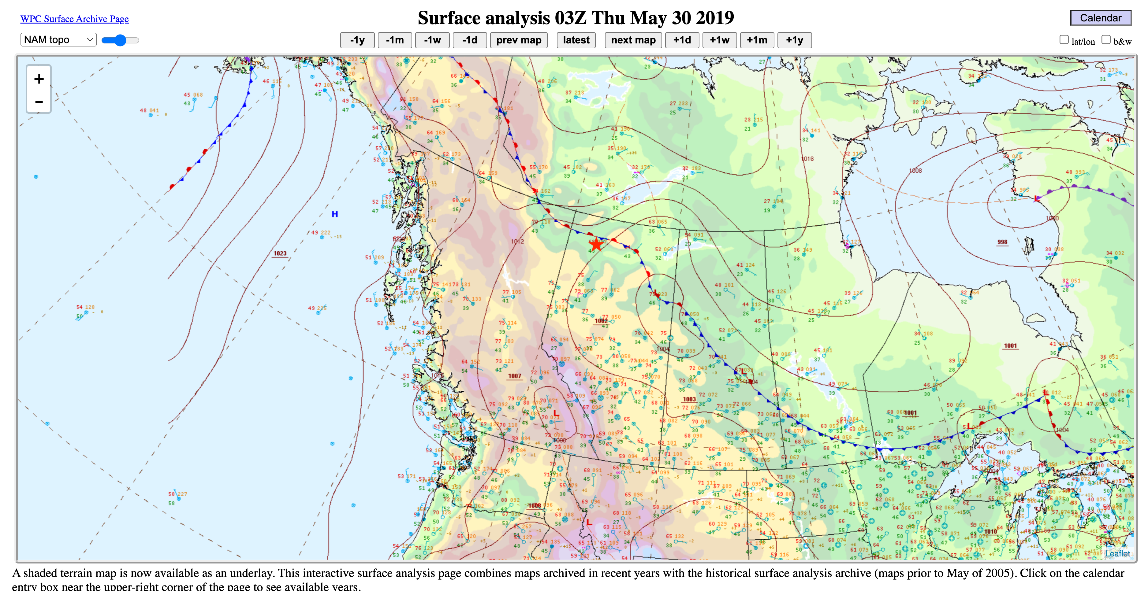
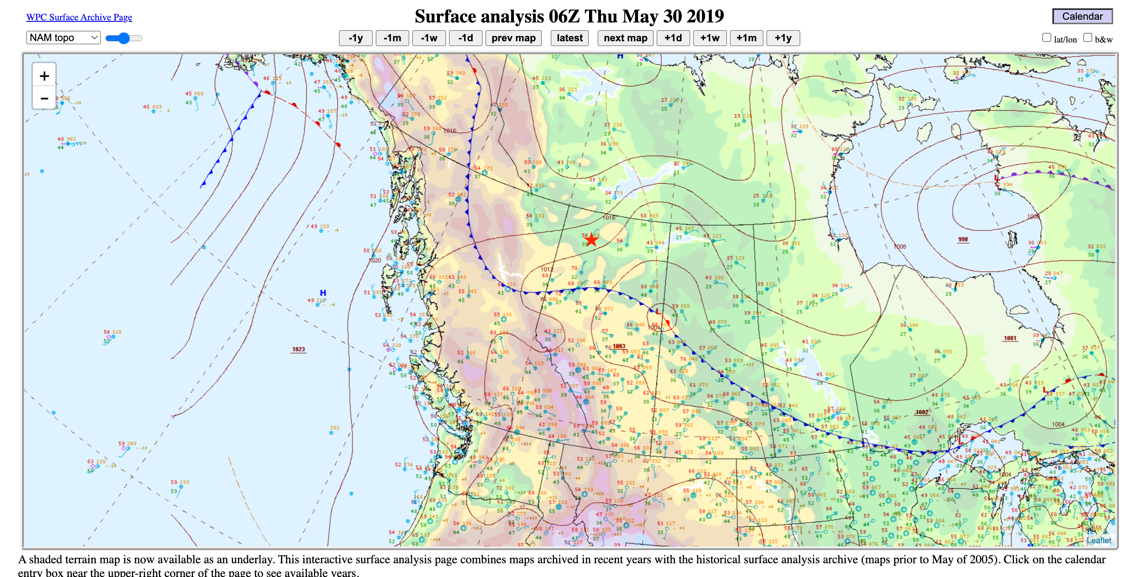
C11 | Second Rapid-Growth: Surface Fronts | Access the 100 m, 10 m, and surface weather maps for wind, humidity, and temperature via the Forecast Tools button in the page header above. Tie the frontal-related weather (03Z and 06Z on 30 May 2019) to fire-fuel-indices and fire-weather-indices to explain why the fire evolved the way it did. View lecture snippets HL02e and HL02f if needed. xxx. Lab Exercise - Give a weather briefing. [see Piazza for the weather briefing schedule] |
Describe the unexpected changes in near-surface weather due to frontal passage, and how it affected fire growth. Relate weather to changes in fuel and fire indices. Use thermodynamic principles to explain why relative humidity increases when temperature decreases, even with no addition of moisture to the atmosphere. |
| Day 10: 3 Oct 20234 |
C12 | Recap Briefing | Work in teams to create concise, informative, captivating fire-weather briefings. Lab Exercise - Forensic weather briefing re-cap of the High Level fire, weather, and societal impacts. |
Synthesize your fire, synoptics, and dynamics knowledge into a coherent understanding that you can describe to other technical and lay personnel. Demonstrate that ability in weather briefings that you give. |
Note: lecture snippets may not be provided for all case studies. They were provided during the first few weeks to: (1) accommodate students who added the course late; and (2) to demonstrate how to utilize NWP, satellite data, and other products to give concise, informative weather briefings.
| Date | Item | Topic | Assignment | Learning Goals. By the end of this section, you will be able to ... |
|---|---|---|---|---|
| Day 11 on 17 Oct 2023 |
E1 | Surface map analysis | Read all the met concepts topics in section mc05.1, including map analysis instructions and exercises. Review how cyclones and associated fronts evolve and move. Practice analyzing surface weather maps and identifying surface fronts (see Stull p280-281 in Chapter 9) by their pressure, temperature, humidity, and wind signatures. Lab Exercise - In class, do map analyses for items mc05.1b and f . Homework: Analyze isotherms, isobars, highs, lows, and fronts, given the surface observations of exercise mc05.1g. |
Interpret surface weather info from station plot models. Draw isotherms, isobars, and other isopleths given the plotted surface data, given data that is sometimes missing, incorrect, or illegible. Explain what defines a weather front, and how to analyze them on weather maps. |
| Day 12 on 19 Oct 2023 |
E2 | Wildfire ignition basics | Read the fire-basics on wildfire ignition and lightning fb7.
xxx. Lab Exercise - Give a weather briefing. [see Piazza for the weather briefing schedule] |
Explain what is needed for wildfire to ignite, and compare nature vs. human sources of ignition. Access and utilize lightning-detection networks and lightning forecast sites. |
| Day 12 on 19 Oct 2023 |
E3 | Overview, ignition & initial growth | Read the Kimiwan fire characteristics and evolution. Learn of some of the impacts and stories in the news. Access CIFFC and GWIS to get fire statistics and the National Preparedness Level. View the associated lecture snippet K01 by Chris Rodell, if you missed lecture.
xxx. Lab Exercise - Kimiwan Complex ignition and initial growth. |
Define what a fire complex is. Determine the Fire Preparedness Level for this and other fires. Access CIFFS and GWIS to get characteristics and statistics of this fire. Identify relevant surface features and synoptic features affecting ignition and initial growth. Relate mesoscale convective indices such as CAPE to potential thunderstorm intensity. |
| Day 12 on 19 Oct 2023 |
E4 | Spring Dip | Learn the basics about Spring Dip, and relate it to the Kimiwan fire. Access the Alberta Wildfire Status Dashboard for the main fire ID SWF-068. Utilize the WorldView "land surface reflectance" product to see satellite images of vegetion/fuels during and after the spring dip. View the associated lecture snippet K02 by Chris Rodell, if you missed lecture.
xxx. |
Define "spring dip", explain what causes it, and how it affects fires. Utilize the "land surface reflectance" product in WorldView satellite imagery to view and explain how the spring dip affected the Kimiwan complex. |
| Day 13 on 24 Oct 2023 |
E5 | Precursor Conditions & Ignition - Cyclone #1 | Examine drought intensity via the fire-weather Build-up Index. Determine lightning locations from the first weak front that might have ignited the fire on 4 May 2023. More about other fire weather indices: fuel types (fb18), rate of spread (fb19), head fire intensity (fb20), etc. xxx. |
Use observed and modeled climate and fire weather to determine precursor conditions for the fire. Use the blitzortung.org website to locate current and historical lightning strikes. |
| Day 13 on 24 Oct 2023 |
E6 | Surface fronts: horiz. and vert. structure | Do the readings given in mc05.2 thru mc05.3. | Describe the arrangement and evolution of temperature, pressure, winds, clouds, and precipitation for warm and cold fronts. Anticipate the weather changes associated with frontal passage. Explain the synergy between cyclones and fronts. |
| Day 14 on 26 Oct 2023 |
E7 | Fronts: mid & upper troposphere. Frontogenesis |
Do the readings given in mc05.4 thru mc05.6. | Describe the structure and formation of occluded fronts. Explan howTROWALS are associated with occluded fronts. Discuss tropopause folds and upper-level fronts. Examine different theories for fronts and cyclones, including various conveyor-belt and cyclogenesis approaches. |
| Day 15 on 31 Oct 2023 | E8 | Fire Growth and Change - Cyclone #2 | See how the "dry"cold front is well defined in the satellite video of smoke, although an interesting complication might be a double front. Caution about interpreting images of smoke streaklines vs. trajectories vs. streamlines (Stull section 17.8). View the associated lecture snippet K04 by Chris Rodell to see how the second cyclone and fronts evolved, affecting the Kimiwan complex. [Topics for the lab exercise: Use Worldview satellite imagery see how wildfire smoke can be used to identify cold-frontal passage from the second cyclone on 15 May. View the associated lecture snippet K03 by Chris Rodell, if you missed lecture. ] Lab Exercise - Give a weather briefing. Lab Exercise: See handout for the Kimiwan Complex fires, for the cold front(s) of cyclone #2. |
Use satellite imagery to identify mid-latitude cyclones and fronts. Use tracers such as smoke to help locate fronts. xxx |
| Day 15 on 31 Oct 2023 | E9 | Upper-air Support - Cyclone #2 | Discussion of upper-level fronts (mc05.5) and frontogenesis (mc05.6). Learn how divergence in the upper troposphere leads to cyclogenesis (Rodell's lecture snippet K05). Use this info to explain why cyclone #2 strengthened (Rodell's lecture snippet K06). Follow the evolution of the 50 kPa trough and closed low (Rodell's lecture snippet K07). | Explain the relationship between upper-air patterns and the role of divergence in cyclogenesis. Explain the terms in the kinematic frontogenesis eq. Describe the role of thermodynamics and dynamics in frontogenesis. Explain the relationship between upper-level fronts, tropopause folds, atmospheric rivers, and surface fronts. |
| Day 16 on 2 Nov 2023 | E10 | Cyclone #3 - Evolution | An overview of the characteristics of cyclone #3 (Rodell's lecture snippet K08), its formation via lee cyclogenesis (Rodell's lecture snippet K09), and upper-level interaction and difficulties in making forecasts (Rodell's lecture snippet K10). Multi-day (18-25 May 2023) GOES-west video of cyclones & smoke in W. Canada. See cyclone#2 leaving the area. See ridge breakdown, creating cyclone#2.5 (19 May) with dry cold front over fire. Lab Exercise - Give a weather briefing. |
Explain how lee cyclogenesis works. Explain how surface cyclones can lose upper-air support and die. Describe the change of NWP forecast skill with lead time. Explain what happend during ridge breakdown. |
| Day 17 on 7 Nov 2023 |
E11 | Cyclone #3 - Upslope Flow & Precipitation | Re-view the Multi-day GOES-west video again from item E10 above, showing cyclone #3. Review mc06.3 on convective cumuliform clouds vs. upslope stratiform clouds. Describe upslope flows around cyclone #3 during 22-24 May 2023 causing clouds and precip. over the fire, by viewing wind streamline animations in the Fire Weather Foecast model. Compare the satellite imagery with the weather maps in the Forecast Tools. Start tephigram lectures (see item F1 below). |
Describe how the average terrain slope in the prairie provinces can enable precipitation if winds are from the east. |
| Day x | xx | |||
| Day x | xx |
| Date | Item | Topic | Assignment | Learning Goals. By the end of this section, you will be able to ... |
|---|---|---|---|---|
| Day xx xx xx xxxx |
G1 | Midterm Exam | Study for the midterm exam, which will be 50 minutes long, written on paper in class. Open books, notes, laptops, calculator. (Note: after the exam, we will have a normal lecture, covering the next fire - see the Schedule - Part 2). A cross-reference list of study topics will be provided on Piazza and Canvas before the exam. An optional review session (via zoom) will be scheduled a day or two before the exam. |
Demonstrate your ability to explain and utilize the fire basics and meteorological concepts covered so far in this course. |
| Day x | xx |
| Date | Item | Topic | Assignment | Learning Goals. By the end of this section, you will be able to ... |
|---|---|---|---|---|
| Day 18 on 9 Nov 2023 | F1 | Tephigrams | Tephigrams (mc07): Review the origins of the tephigram, and the types of lines on it. See how to determine (1) thermodynamic state, (2) processes such as lifting that change the state, (3) plotting environmental soundings, (4) determining buoyancy, (5) CAPE and Tstorms, (6) static & dynamic stability. Lab Exercise - Give a weather briefing. |
Be able to plot soundings on tephigrams, determine instabilities including deep convection (thunderstorms), and interpret soundings. |
| Day 19 on 16 Nov 2023 | F2 | Sparks Lake demo briefing | Use the Rubric to evaluate the 45-minute presentation on the Sparks Lake, BC, fire. This is a demo presentation given by Jalena Bennett, to serve as a model for upcoming group presentations for the 4 remaining fire cases. |
Discuss the interaction between the fire and weather for this case. Make fire-weather forecasts, considering synoptic, mesoscale, terrain, and other factors. Improve your ability to work in a team and make presentations. |
| Day 19 on 16 Nov 2023 | F3 | PyroCB | Lecture by Rodell on pyroCB (cumulonimbus flammagenitus). Lab Exercise - Give a weather briefing. |
Explain the atmospheric and fire conditions necessary to form a pyrocb. Describe the hazards associated with pyrocb, and how it affects fire fighting. Locate the geographies where pyrocb are most frequent. |
| Day 20 on 21 Nov 2023 | F4 | ABL & NWP | First 50 minutes: Lecture by Stull on Atmos. Boundary Layer (ABL) Overview. |
Describe how the ABL evolves with time in both fair weather and synoptically windy weather. Explain ABL flows in mountains regions, and near fronts and thunderstorms. Describe how statistics can be used to describe turbulence strength. Relate smoke dispersion to stability. Describe the NWP process. Explain teh pros and cons of ensemble forecasting. |
| Day 20 on 21 Nov 2023 | F5 | Lab | Last 30 minutes: • The groups who will present the next fire case (Ft. McMurray) will plan which students present which parts. Resources: Presentation Tips and use the the link to those Fire Cases. • The other groups start the assigned readings on Numerical Weather Prediction (NWP, Stull, Chapter 20), and get started on the Canvas quiz. |
Exlain the steps in NWP, and relate NWP to wildfire weather forecasting. |
| Day x | xx | |||
| Day x | xx |