
EOAS Climate Research
Explore a variety of climate research happening at EOAS.
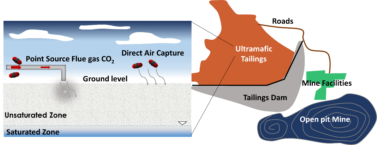
Sequestering carbon dioxide with nickel and diamond mine tailings
Sterling Vanderzee, PhD Candidate

I am excited about working with real companies and communities to help develop and implement new technologies for reducing the greenhouse gas emissions from industrial activities.
Research
The goal of my research is to reduce the greenhouse emissions from nickel and diamond mining operations. We do this by using the magnesium-rich waste solid products of mining, called mine tailings, to convert carbon dioxide (CO2) gas into solid magnesium-carbonate minerals. Mine tailings are essentially the finely ground rocks that remain after the nickel and diamonds have been removed. The trick to this process is being able to identify highly CO2-reactive rocks within the mine, so that the tailings generated from these rocks can be targeted for use as feedstock for sequestering CO2. By using the most CO2-reactive rocks we can sequester CO2 more rapidly and do it without having to use any chemicals or expensive and energy-intensive technologies that require high temperatures and/or high pressures. The CO2-reactive mine tailings can naturally remove CO2 from the atmosphere, and also capture it from the CO2-rich exhaust gases produced by onsite diesel electricity generators. Most of my research involves “treasure hunting” for these highly CO2-reactive rocks through data analysis and quantifying the carbon sequestration potential of different mines and mineral deposits.
References
Vanderzee, S.S.S., Dipple, G.M., and Bradshaw, P.M.D. (2019) Targeting Highly Reactive Labile Magnesium in Ultramafic Tailings for Greenhouse-gas Offsets and Potential Tailings Stabilization at the Baptiste Deposit, Central British Columbia (NTS 093K/13, 14). Geoscience BC Summary of Activities 2018: Minerals and Mining, 109–118.
Characterizing the potential of ultramafic mine waste to capture and store carbon
Xueya Lu, PhD Candidate
I became interested in the field of carbon capture and storage because of a journal article that I came across during the last year of my university. The papers talk about all the existing and developing carbon sequestration technology that can be helpful to prevent climate change. At first I thought this is a great idea and I think there is lots of potential in research. Later as I worked towards my research, I found carbon sequestration using industrial wastes to be an actual applicable technology and that could really make a change.
I think a major difficulty is to engage all the communities around campus and to get people’s attention on the current climate action. There are many research projects going on and it's going to be hard for many of our colleagues to overcome these barriers. Another challenge would be to identify all the potential funding and make good use of these funding opportunities. I see our society as a whole become more careful and caring about climate change. I see many people, companies, government issuing policies, pay money and pay attention to all kinds of climate action to make changes. Research related to carbon capture, storage has become more popular.
Research
I'm part of the CarbMin Lab and the SCO2UT project. I am excited about working with real companies and communities to help develop and implement new technologies for reducing the greenhouse gas emissions from industrial activities.This ongoing project looks into sequestration of CO2 in ultramafic tailings. My research is partnered with the mining industry to help them gain understanding in reusing their tailings for carbon sequestration. I examine mine sites that host ultramafic rocks which have the potential to capture carbon directly from the atmosphere and produce carbon offset credits. I have been conducting laboratory-scale experiments and geochemical numerical models to quantify the number of magnesium cations that can be easily leached from ultramafic wastes under atmospheric conditions. I am very excited about this work and see myself keep progressing in the field of carbon capture, help support the fight for climate change and support innovative research as a scientist and an adventurer. This carbon capture technology has great potential to make dramatic changes to the world’s mining pattern long-term.
References
Lu, X. (2020). Characterization of ultramafic mine tailings reactivity for carbon capture and storage (T). University of British Columbia. Retrieved from https://open.library.ubc.ca/collections/ubctheses/24/items/1.0394123
(2020) Carbon Mineralization in Ultramafic Mine Tailings: A Pathway to Negative Greenhouse Gas Emissions Dipple G, Lu X, Vanderzee S, Wynands E, Baidya D, Ghoreishi-Madiseh SA & Cutts J https://doi.org/10.46427/gold2020.587
(2019) Characterization of Ultramafic Mine Tailings Reactivity for Carbon Capture, Utilization, and Storage Lu X, Dipple G & Turvey C Lu X, Dipple G & Turvey C (2019) Goldschmidt Abstracts, 2019 2067
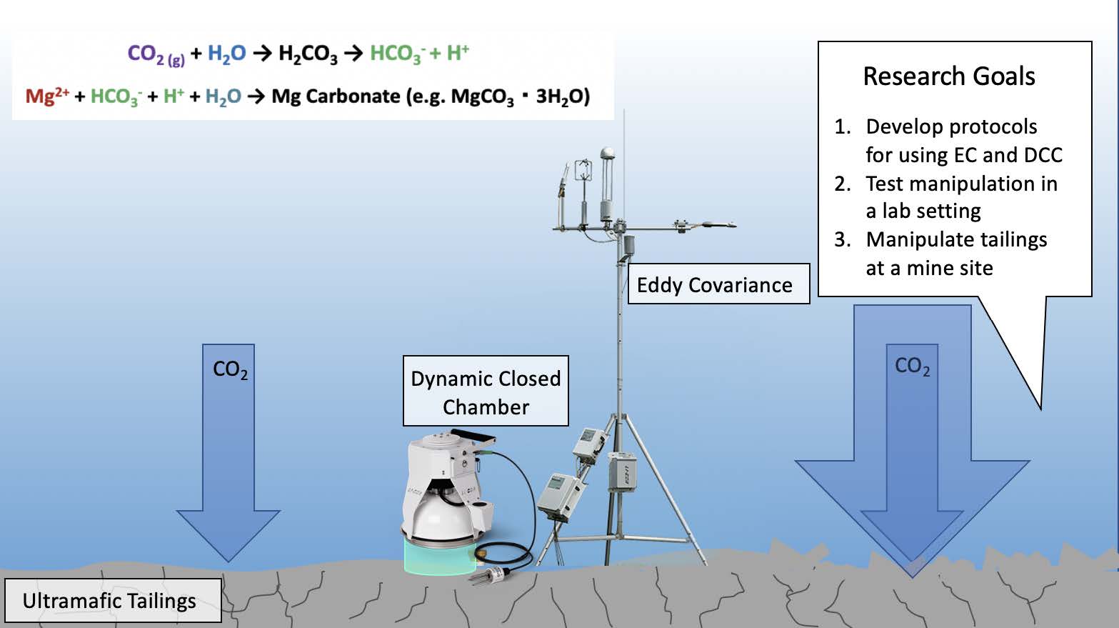
Quantifying passive CO2 exchange between a carbonate playa and the atmosphere: a natural analogue to CO2 capture in ultramafic mine tailings
Anne-Martine (Marti) Doucet, MSc Candidate
- From Ottawa, ON, Canada
- Conducted field work in Atlin, British Columbia
- Collaborates with the UBC Carbmin Lab
Research
The carbonate playas of Atlin (British Columbia) release and uptake CO2, which make them a good model for carbon exchange between mine waste and the atmosphere. When ultramafic rock is mined, the rock waste is disposed of in ponds, which react with the atmosphere, passively uptaking CO2 and forming a carbonate mineral. These playas are a great setting to validate two distinct methods, Eddy Covariance (EC) and Dynamic Closed Chamber (DCC), that measure this carbon exchange in real-time. Our field campaign in August 2020 demonstrated that EC and DCC show considerable promise and has motivated further data collection and analysis to better understand unexpected interactions between CO2 fluxes, carbonate soils, and weather. The next steps are to apply these methods on ultramafic mine tailings that actively uptake carbon, with the aim of helping estimate a mine’s carbon footprint. Passive or engineered carbon mineralization, which occurs when ultramafic waste rocks uptake CO2 and form a solid mineral, are long-term solutions for climate change mitigation. This is an interesting field to study in right now and it excites me that a small piece of my research could contribute to measuring and tracking this phenomenon!
References
Atlin formation: Power, I. M., Harrison, A. L., Dipple, G. M., Wilson, S. A., Barker, S. L. L., & Fallon, S. J. (2019). Magnesite formation in playa environments near Atlin, British Columbia, Canada. Geochimica et Cosmochimica Acta, 255, 1–24. https://doi.org/10.1016/j.gca.2019.04.008
From Atlin as an analogue towards engineered systems: Power, I. M., Harrison, A. L., Dipple, G. M., Wilson, S. A., Kelemen, P. B., Hitch, M., & Southam, G. (2013). Carbon mineralization: From natural analogues to engineered systems. Reviews in Mineralogy and Geochemistry, 77(1), 305–360. https://doi.org/10.2138/rmg.2013.77.9
Case study to inform the application of EC and DCC at a mine site (engineered system): Wilson, S. A., Harrison, A. L., Dipple, G. M., Power, I. M., Barker, S. L. L., Ulrich Mayer, K., … Southam, G. (2014). Offsetting of CO2 emissions by air capture in mine tailings at the Mount Keith Nickel Mine, Western Australia: Rates, controls and prospects for carbon neutral mining. International Journal of Greenhouse Gas Control, 25, 121–140. https://doi.org/10.1016/j.ijggc.2014.04.002
Measuring enhanced CO2 sequestration into ultramafic mine tailings using soil gas flux chambers and eddy covariance systems
Frances Jones, MSc Candidate
I recognized the need for raw materials (e.g. nickel) and the role that mining will play as countries decarbonize. I was interested in making mining more sustainable and potentially a carbon sink. Challenges when it comes to making the university more sustainable is that UBC has been historically stubborn about divesting from fossil fuels and they have yet to acknowledge that divestment can be the most significant environmental step an institution can make. UBC should not be allowed to tout that it is carbon neutral (which it aims to become by 2030) or that it is a climate leader while continuing to profit from the fossil fuel industry. The researchers I work with give me hope as we continue to push to help industries/ companies to become more innovative and sustainable.
Research
According to all climate projections by the IPCC, removal of carbon dioxide from the atmosphere is necessary to successfully limit global warming to 1.5°C above pre-industrial levels by 2100. Studies have observed CO2 sequestration occuring passively in ultramafic mine tailings by the formation of hydrated magnesium-carbonate minerals. Conventional methods for measuring rates of drawdown have proven to be challenging and inefficient due to the intensive field and laboratory labour and low resolution. Two novel techniques will be used to measure rates of drawdown at a mine site. Dynamic Closed Chambers (DCC) and Eddy Covariance (EC) are used extensively in agricultural and environmental sciences and are widely accepted methods for measuring gas exchange between the soil and atmosphere. Using these techniques a mine can accurately measure what percentage of their emissions they are offsetting and low cost-low intervention techniques to increase sequestration can be measured in real time. Carbon capture and storage will play a large role in Canada reaching its climate goals so I’m excited to be doing research in this field.
References
Wilson, Siobhan A. et al. 2014. “Offsetting of CO2 Emissions by Air Capture in Mine Tailings at the Mount Keith Nickel Mine, Western Australia: Rates, Controls and Prospects for Carbon Neutral Mining.” International Journal of Greenhouse Gas Control 25: 121–40. http://dx.doi.org/10.1016/j.ijggc.2014.04.002.
Bea, S.A. et al. 2012. “Reactive Transport Modeling of Natural Carbon Sequestration in Ultramafic Mine Tailings.” Vadose Zone Journal 11(2): vzj2011.0053. http://doi.wiley.com/10.2136/vzj2011.0053 (December 29, 2020).
Reactive transport modelling carbon sequestration by the Iroko Tree
Hannah Gatz-Miller, PhD Candidate

As the world careens toward climate crisis and we, as scientists, search for solutions, the potential of plants to do some of the heavy lifting should not be overlooked. One key plant of interest is the Iroko. The Iroko (Milicia excelsa) is a deciduous tree found across western and central Africa (e.g. Ivory Coast, Cameroon and other countries). The tropical soil in which it grows is often heavily leached and acidic (pH 4-6), while the bedrock is mainly igneous. Despite this, the soil directly around the Iroko has been found to be alkaline (pH 7-10), and full of calcium-carbonate blocks. Research has suggested that the Iroko itself facilitates a pH change directly around its roots, creating a soil environment ideal for calcium-carbonate to precipitate.
Calcium carbonate is made up of three components: calcium, oxygen, and carbon. Through what has been termed the ‘oxalate-carbonate pathway’, the carbon in the calcium-carbonate that precipitates around the Iroko, is the same carbon that the Iroko takes up from the atmosphere during photosynthesis. This carbon is then stored as mineral in the ground, making the Iroko and its oxalate-carbonate pathway, a natural sink for atmospheric carbon.
From here, other questions arise: how exactly does the oxalate-carbonate pathway work? How long does it take for the Iroko to do this? How much carbon can it sequester? What about the other ingredients (i.e. calcium)? These types of questions are difficult to answer because of the long timelines (an Iroko tree’s lifespan can be at least 170 years or more), and number of variables to consider.
This is where my research can help fill in the blanks.
I use reactive transport modelling to study the interactions between soil and roots. This type of modelling is called “reactive transport” because it is used to model the movement and chemical reactions of water, gas, and various components dissolved in the water (for example, carbon, calcium, and oxygen) as they move through the ground, interact, and change. Through reactive transport modelling the oxalate-carbonate pathway, for example, I have found that the majority of the calcium needed to form the calcium carbonate around the Iroko must come from the weathering of other minerals, and that there are various avenues by which the Iroko may sequester up to 1 tonne of carbon as calcium carbonate mineral over its lifetime.
Not unlike the oxalate-carbonate pathway itself, my route to studying soil and plant interactions has not been straightforward. My undergraduate degree was in geology, and my master’s thesis focused on groundwater contamination by jet fuel. However, as I have learned more and more, it is impossible to truly separate the different scientific disciplines from one another—especially when attempting to solve real-world problems. To do so is limiting and to our own detriment as researchers and problem solvers. Though I do often find myself baffled at the strange behavior of plants compared to rocks, I am thankful to have this opportunity to investigate their confluence and see where it leads.

Figure demonstrating the calcium flux related to the Iroko from Gatz-Miller et al., 2022
References
Cailleau G., Braissant O. and Verrecchia E. P. (2011) Turning sunlight into stone: The oxalate-carbonate pathway in a tropical tree ecosystem. Biogeosciences 8, 1755–1767.
Gatz-Miller H. S., Gérard F., Verrecchia E. P., Su D. and Mayer K. U. (2022) Reactive transport modelling the oxalate-carbonate pathway of the Iroko tree; Investigation of calcium and carbon sinks and sources. Geoderma 410. Available at: https://linkinghub.elsevier.com/retrieve/pii/S001670612100745X.
Mayer K. U., Frind E. O. and Blowes D. W. (2002) Multicomponent reactive transport modeling in variably saturated porous media using a generalized formulation for kinetically controlled reactions. Water Resour. Res. 38, 13-1-13–21. Available at: http://doi.wiley.com/10.1029/2001WR000862.
Numerical modeling of mine waste and carbon sequestration practices
Katherine Raymond, Research Scientist
I became a hydrogeologist because I was passionate about protecting the earth since I was a kid and first learned about climate change in elementary school. When I started university, I knew I wanted to do something related to protecting water as a resource, but I didn’t actually learn about what hydrogeology was until my first year at the University of Waterloo. Through a bit of serendipity, I had a professor who told me what it was and encouraged me to switch degrees (from Environment and Resource Studies), and I am happy I did!
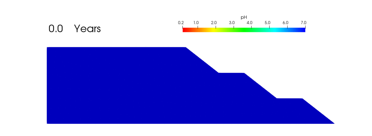
Animation showing changes in pH (measuring acidity and potential metal leaching) in a conceptual waste rock over 50 years produced using the reactive transport model MIN3P.
Research
In order to extract valuable resources such as metals and gems, mines must remove massive amounts of non-valuable rock (referred to as “waste rock”) to reach them. These piles are often stored above ground and may be up to 500,000,000 m3 of rock (a volume which could fill 200,000 Olympic-sized swimming pools). Additionally, some of these materials are mixed with other chemicals and broken down into small particles during mineral extraction (called “tailings”), which must also be stored. Similar to the mechanism of rust forming on iron, when removed from the ground and exposed to oxygen in the air, waste rock may break down and release potentially harmful metals, which then require water treatment if poorly managed.
My previous research focused on storage design strategies for waste rock piles in order to minimize contaminant release and water treatment requirements. I do this by using computer models to help conceptualize what is happening within these piles and to improve long-term waste rock storage design strategies. I have recently joined the CarbMin group, where I hope to apply these modeling techniques to investigate how to enhance CO2 sequestration (i.e. taking CO2 out of the atmosphere where it acts as a greenhouse gas and storing it as a mineral/solid phase).
This research excites me because it feels like there is so much to discover. Numerical models are tools to help you solve your scientific questions and quite engaging; you have to know and input all the components that go into the model to make it produce realistic results, and in return, the model gives you images of what processes are happening below the surface which we normally cannot see (or try to see through very limited data points).
This research is also important because “If it can’t be grown, it must be mined”. Even for more sustainable energy sources and products, we will continue to rely on metals extracted from the earth to move forward into the future. Understanding how to responsibly manage the waste produced from mining activities is an essential part of our sustainable future and protecting the land and water for future generations. Building carbon sequestration goes beyond that; not only making a necessary industry (mining) more sustainable, but actually teaming up with the industry to help combat climate change as we extract materials using better techniques to improve our society. This work feels like a necessary step to improve society, and is extremely rewarding in that regard!
Episodic fluid flow and mass transfer along pre-existing carbonate veins: implications for metal endowment in carbonate-hosted hydrothermal systems
Andrew Steiner, Phd Student
I am a geologist studying the processes that control where hydrothermal fluids flow and how they deposit metals. My interest in earth science materialized from a love of the outdoors, physical geography and science. I found myself drawn to mineral deposit geology because it integrates so many sub-disciplines within the earth sciences and involves constant problem solving. The ongoing move from fossil fuel-based societies to sustainable ones will require an enormous amount of metal, and in order to meet this demand, we need robust geological models which we can use to find and develop resources. I think the biggest challenge for the industry moving forward is changing its public perception. This will require better education, outreach and communication with people local to mine or exploration sites. The fantastic progress made by modern mining companies to make mining more environmentally friendly (carbon-neutral mines, clean water drainage, the rehoming and protection of species affected by mining, post-mining reclamation etc.) is already helping to change public perception.
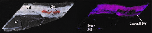
Example of a vein filled with an altered, UV-fluorescent (UVF) version of the mineral calcite (Cal) and the mineral realgar (Rlg) in a limestone (Lst) rock. Left: daylight photograph; right: UV photograph.
Research
My research has focused on a type of gold deposit called a Carlin-type deposit in Yukon. This deposit formed when ancient hot fluids (called hydrothermal fluids) carrying gold interacted with limestone. My research explores the geological conditions that caused this fluid flow and which geological features helped or hindered fluid flow through the rocks. While my chosen study area was a gold deposit, my research is applicable to other hydrothermal systems in limestone, including ones that deposit critical metals such as Cu, Zn, and W. I found that the rocks in the deposit were tilted, faulted, and folded so that they were steep at the time of fluid flow, with abundant veins (fractures filled with minerals). The fluids flowed through these veins, and chemical reactions dissolved the existing minerals and replaced them with a chemically-modified version of the same minerals that fluoresce under UV light. The fluids needed to leave the veins and flow through the surrounding limestone to deposit gold. This happened where the veins were wider spaced, narrower or not well connected, or when they intersected a more permeable limestone layer. Age dating the veins revealed that there were several fluid flow events over about 50 million years. This research is important because it suggests that people exploring for limestone-hosted hydrothermal deposits should look for areas with extensive pre-existing vein networks and should consider the relative permeability of the host rocks and the vein or fracture networks used by the fluids when assessing the potential size of a discovery.
References about the role of mining in sustainable societies:
Herrington, R., 2021, Mining our green future: Nature Reviews Materials, v. 6, p. 456–458.
Vidal, O., Goffé, B., and Arndt, N., 2013, Metals for a low-carbon society: Nature Geoscience, v. 6, p. 894–896.
References about the Yukon deposit:
Coulter, A.B., Lane, J., and Steiner, A., 2018, Osiris cluster Carlin-type gold, east-central Yukon, in MacFarlane, K.E. ed., Yukon Exploration and Geology 2017, Yukon Geological Survey, p. 65-74.
Steiner, A.P., and Hickey, K.A., 2021. Bedrock geology map of the Nadaleen-Anubis fault corridor, eastern Rackla belt (parts of 106C/1,2). Yukon Geological Survey, Open File 2021-1, scale 1:20000, 2 sheets.
Steiner, A.P., Hickey. K.A., Huntington, K.W., Schauer, A.J., 2022, 'Roll-front' mass transfer of carbonate cations in Carlin-type gold deposits: insights from UV-fluorescent calcite veins. In press, Economic Geology.
Economic value of weather forecasts for run-of-river hydropower systems
Abhinab Kadel, MSc Candidate in Atmospheric Science

My background is in renewable energy. As the raw materials for renewable energy is highly dependent on weather, I was interested in learning more about weather forecasting. Currently, I am a member of the UBC Weather Forecast Research team, and in collaboration with The International Centre for Integrated Mountain Development (ICIMOD), Nepal. In terms of challenges towards progress on climate action, I expect there to be increasing pressure on UBC to ensure that there is good quality of services without increasing the carbon footprint drastically as incoming student numbers increase every year. The Climate emergency declaration and formation of Climate Emergency Advisory Committee are good first steps to address this challenge.
Research
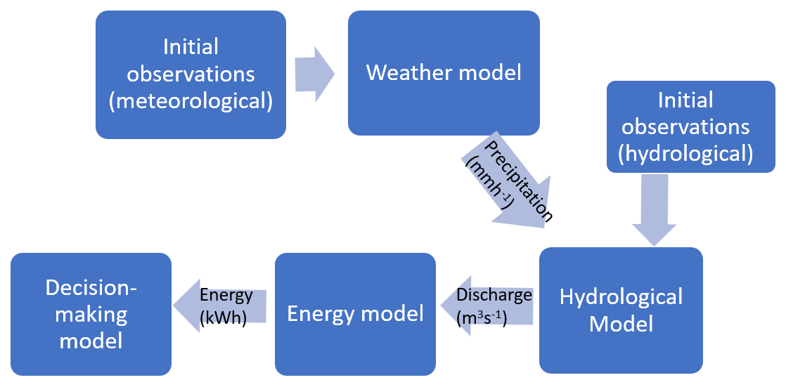
The raw materials for renewable energy generation are highly dependent on weather, thus weather forecasting plays a key role in renewable energy systems. My research combines interdisciplinary concepts in engineering, weather forecasting and energy economics to predict water discharge values in run-of-river hydroelectric systems. River discharge forecasts are obtained from the streamflow forecasting tool developed by International Centre for Integrated Mountain Development (ICIMOD)1. It provides forecasts using 52 different possible scenarios. The maximum and minimum values of river flow using these different scenarios are provided for 10 days into the future. Such weather forecasting products are widely used by hydropower operators such as BC Hydro2. However, they are not yet used in Nepal.
Unlike BC, Nepal has a majority of electricity generation through run-of-river hydro systems. Run-of-river systems have a smaller barrier on a river or stream to divert water towards turbines. A weir does not create a lake like conventional dams do. Hence, there are limited strategies to control water flow. As there are limited possibilities for water management, I am focusing on evaluating how the forecasts could be used for different electricity markets in Nepal. The focus will be on wholesale electricity markets, i.e., trading arrangements between electricity producers and the utility. For example, the current market provision in Nepal is to have power purchase agreements that guarantee fixed rates per energy yield for 25-30 years. My research aims to explore the utility of inflow forecasts for other market scenarios such as day-ahead trading, where hydropower operators need to declare beforehand the amount of electricity they plan to sell to the utility.
Renewable energy sources like hydroelectric power generation provide an alternative to fossil fuel-based economy. Unlike nuclear and fossil fuel sources, which are highly location and technology dependent, renewable energy sources are modular, making them ideal for developing economies. Probability forecasts aim to minimize the uncertainty associated with renewable generation, expanding their integration possibilities in a community.
References
1Boucher, M.A. & Ramos, M.H. (2018) Ensemble Streamflow Forecasts for Hydropower Systems. Handbook of Hydrometeorological Ensemble Forecasting, pp 1-19
2ICIMOD, https://servir.icimod.org/science-applications/streamflow-prediction-to…. Accessed: Feb 10, 2021
Cracked Mountain: An explosive subglacial basaltic volcano of SW British Columbia
Martin Harris, MSc Candidate
I am fascinated by magmatic processes and have wanted to make a career out of furthering the understanding of past volcanic eruptions to better prepare for and understand future eruptions. When it comes to major challenges towards progress on 7 areas of action from the UBC Declaration of a Climate Emergency, I believe the biggest challenge we face is transitioning from fossil fuel-based investments. It is going to take a significant effort from the leaders of UBC to divest, and this process may take a long time, which ultimately limits the ability for immediate climate action. The substantial dialogue and climate marches show that there are more and more people engaged in tackling these climate challenges, and that gives me hope for an improving future.
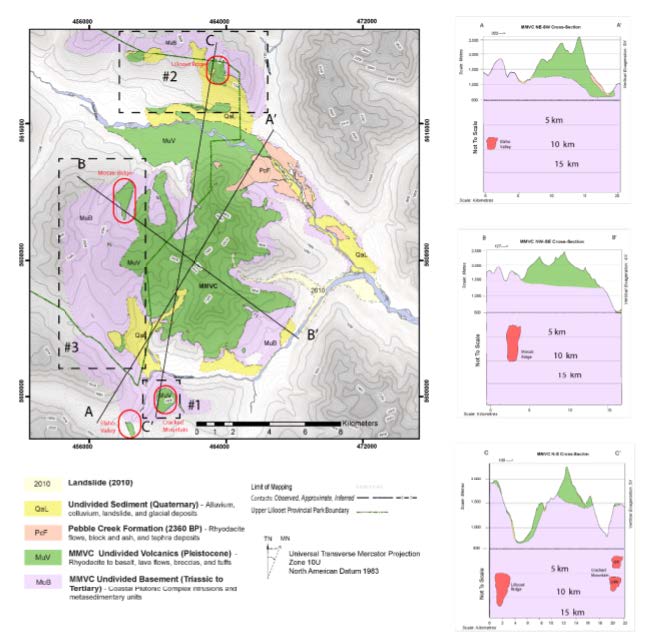
Undivided Geological Map of Mount Meager Volcanic Complex (MMVC) (Harris et al. 2020; Hickson et al.,1999; Read.,1979; Roberti et al., 2018; Stewart et al., 2008; Woodsworth., 1977). Schematic depths of magma crustal storage are shown for volcanic centres: Cracked Mountain, Lillooet Ridge, Mosaic Ridge, and Elaho Valley (outlined in red). These depths are based on thermodynamic modeling with Rhyolite-MELTS (Gualda and Ghiorso, 2015)
Research
My research aims to fully understand the physical and chemical evolution of Cracked Mountain, a small volcano associated with the larger Mount Meager stratovolcano located 60 km from Pemberton, BC. Cracked Mountain volcano is of significant interest because it erupted beneath Cordilleran glacial ice during the Pleistocene; this interaction between erupting lava, glacial meltwater, and ice resulted in the formation of a unique landform with steep sides and a flat top. Through my work, I investigate the physical processes that occurred during the Cracked Mountain eruption as this contributes to the global understanding of magma-water-ice interactions. The 2010 eruption of Eyjafjallajökull volcano (Iceland) (Cioni et. al 2014) is an example of an explosive subglacial eruption that had significant atmospheric impacts, affecting both climate (i.e. ash sent into the atmosphere) and economic sectors (i.e. air traffic) in Iceland and parts of Europe. As these subglacial eruptions are a present-day hazard, it is paramount to try and further understand their dynamics. Additionally, I study the chemical compositions of the Cracked Mountain rocks because the geochemical signatures retain information on magma sourcing and evolution (i.e. location of magmas in the Earth before the eruption). This work contributes to the overall understanding of where magmas are stored in the Garibaldi Volcanic belt of SW British Columbia.
My favorite part of my research is the ability to tell a story that encompasses the many parts of a past volcanic eruption. Volcanoes are exciting but also extremely hazardous, so by contributing to the field of volcanology, I feel like I am making an impact on the global understanding of these fascinating but dangerous systems. Additionally, my work, in part, has relations to exploring renewable energy in the form of the geothermal potential of Canada. For geothermal energy to be developed, there must be hot subsurface aquifers accurately located. Thus, I have spent the past two summers field mapping volcanoes (including Cracked Mountain) in SW BC as part of the Garibaldi Geothermal Initiative, a National Resources of Canada project. My maps will be used by a future geologist in identifying viable sites for Geothermal exploration. It is exciting to know that part of my research contributes to the development of renewable energy within Canada.
References
Cioni, R., Pistolesi, M., Bertagnini, A., Bonadonna, C., Hoskuldsson, A., and Scateni, B., 2014, Insights into the dynamics and evolution of the 2010 Eyjafjallajökull summit eruption (Iceland) provided by volcanic ash textures: Earth and Planetary Science Letters, v. 394, p. 111–123, doi:10.1016/j.epsl.2014.02.051.
Harris, M., Muhammad, M., Williams-Jones, G., and Russell, J.K., 2020, Bedrock mapping for Mount Meager Geothermal Research Initiative: Geoscience BC, p. 6–29, doi:10.13140/RG.2.2.15103.64169.
Hickson, C.J., Russell, J.K., Stasiuk, M. V, and Swanson, D.A., 1999, Volcanology of the 2350 B.P. Eruption of Mount Meager Volcanic Complex, British Columbia, Canada: implications for Hazards from Eruptions in Topographically Complex Terrain 1: Bulletin of Volcanology, v. 60, p. 489–507.
Glaciers and Ocean Ecosystems in the Canadian Arctic
Stephanie Waterman, Assistant Professor and Oceanographer
I became an oceanographer because, at the time, I saw physical oceanography as a cool application of my love of physics that I could relate to (unlike quantum mechanics which to me was much too abstract). It also provided exciting opportunities to travel and have awesome adventures doing fieldwork. Today, I am motivated by the importance of understanding how the Earth system works so that we can better chart our course to a sustainable future that better manages and protects Earth’s natural systems. I think the biggest challenge toward climate progress lies in accelerating our timelines for climate action. In recent years, there have been many positive changes in the attitudes and ambitions of institutions at many levels with respect to taking action on climate change. However, I believe it is imperative to make progress at a faster rate. The attitudes and ambitions of younger people (like the students I teach at UBC) give me hope. I am inspired by their commitment to positive change with respect to sustainability but also climate justice issues.
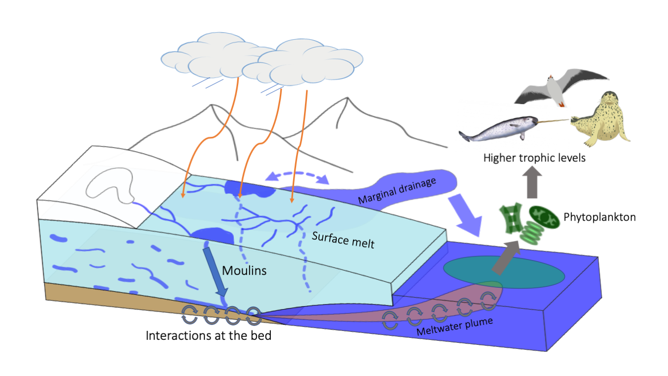
Figure: How does glacial meltwater impact marine life? Glaciers are dynamic systems that pick up nutrients and minerals as the glacier moves and melts. Meltwater enters the ocean from the base of the glacier, below the ocean surface. As this meltwater plume rises, it can bring up both nutrients and minerals in the meltwater as well as deeper seawater that is rich in nutrients. Thus, marine-terminating glaciers might be playing an important role in supporting marine productivity in Jones Sound in the Canadian Arctic Archipelago. This would be consistent with traditional knowledge from Inuit communities which indicates that the waters around glaciers that terminate in the ocean are particularly rich in wildlife.
Research
Glaciers are melting at an alarming rate. The Canadian Arctic Archipelago (CAA) is a hotspot for such melting, and the resulting meltwater has important impacts on marine ecosystems via mechanisms that are poorly understood. In our project, we aim to understand how glacial meltwater impacts Arctic marine ecosystems, including the humans they support. To do so, we make measurements of ice, glacier meltwater and the ocean waters surrounding melting glaciers in order to understand how glacier meltwater impacts nutrients and primary production in coastal waters near ocean-terminating glaciers. We also perform laboratory experiments to better understand how plankton in these environments respond to inputs of glacier meltwater. Finally, we partner with community members of the Inuit Hamlet of Ausuittuq (Grise Fiord) to document and leverage Indigenous knowledge of timing and locations of glacially-driven increases in marine productivity.
Our measurements show that marine waters fed by tidewater glaciers in the Canadian Arctic have elevated nutrient concentrations, and that some types of nutrients are delivered directly by the glacial discharge while others are sourced from deeper marine waters delivered to the surface ocean by upwelling associated with the rising glacial meltwater plume. Further, they suggest that the volume of meltwater determines the amount of nutrients brought to the surface by upwelling. This is important because it suggests that in the future, as glaciers in this region retreat, we expect coastal waters along the archipelago to become less nutrient-dense.
We will leverage our work to empower Northern communities to direct and participate in assessing, understanding and adapting to environmental change. I am most excited by project partnerships with community members of the Inuit Hamlet of Ausuittuq (Grise Fiord). Located on Ellesmere Island NU, the Hamlet is directly impacted by the recent acceleration in CAA glacier melt and its influence on marine ecosystems as community members depend on their local marine environment for traditional harvesting of wildlife for food, resources and, more recently, for attracting tourism. The community has recently expressed interest in understanding the impacts that climate change, and enhanced glacial melting in particular, are having on the marine ecosystems they depend upon. A full-time resident of the Hamlet, Jimmy Qaapik, who has guided scientific expeditions for the Government of Canada’s National Glaciology Monitoring Program for several decades, is a formal co-investigator on our project. Qaapik enables us to incorporate Indigenous knowledge at all stages of our study and helps to ensure significant long-term benefits are created for the Hamlet from this project. Together we aim to develop best practices for the empowerment of Indigenous coastal communities to participate in the monitoring and management of their local ecosystems during a time of extreme change.
References
https://apecs.is/research/polar-and-alpine-research-areas/76-earth-scie…
https://www.theglobeandmail.com/canada/article-new-ways-forward-in-cana…
Understanding and modelling of glacier response to climate change
Valentina Radic, Associate Professor

- Collaborates with the Geography department, Civil Engineering, IRES; Internationally: glaciological community, Intentional Glaciological Society, European Geophysical Union, American Geophysical Union
- Receives funding from NSERC and CFI
- Conducts field work in the Canadian Rockies and the Yukon (Kluane National Park)
- Born in Croatia
I always wanted to be involved in solving physics-based problems related to the real world and using instruments to measure processes and phenomena of the world around me. Studying geophysics promised exposure to field work and using physics and math to resolve problems applied to the Earth. I think each action item on the UBC climate emergency declaration will have its own challenges, but probably one of the biggest challenges would be to enable a collective (systemic) change (action on Climate Emergency) that needs to be embraced by all UBC bodies. Awareness of Climate Change and the need for solutions is much greater now than ever in the past.
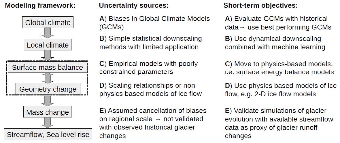
Flowchart of the modelling framework, key sources of uncertainty, and our research objectives.
Research
The retreat of mountain glaciers worldwide is a key indicator of modern climate change, with mass loss from glaciers contributing to sea level rise and to river flows during dry and warm parts of the year. In western Canada, maintenance of low flows by glacier runoff is essential for hydro-power generation, agricultural irrigation and water supply for major cities and small towns. The coming decades will see rapid and unprecedented changes to glaciers worldwide. However, current projections are unable to resolve with certainty how individual river basins will be impacted by the loss of glacier ice in their headwaters. The overarching objective of my research program is to use state-of-the-art field, modelling and data analysis methods to narrow the uncertainties in projections of glacial contributions to streamflow and sea level rise. In particular my research is addressing the following uncertainties:
A) Uncertainty in future climate scenarios, given by Global Climate Models (GCMs), which drive the glacier mass changes.
B) Uncertainty in simple downscaling methods used to convert coarsely-resolved climate fields from GCMs to finely-resolved ones that drive melt processes at the scale of individual glaciers.
C) Uncertainty in empirical melt models which cannot be adequately calibrated in the absence of
observations.
D) Uncertainty in the treatment of glacier dynamics, i.e. how the glacier flows down the valley.
E) Uncertainty in glacier mass loss on regional scale which cannot be adequately quantified in the absence of a historical record of mass changes at this scale.
By resolving the aforementioned uncertainties, our research will ultimately provide projections of glacier contribution to streamflow at the level of detail necessary to inform local policy makers and user communities. The outcomes will define how climate change will tangibly express itself for Canadians and most of the world. I find this goal exciting and challenging at the same time, while collaborating with my grad students is what gives me the optimism and motivation to keep doing what we are doing.
References
Anderson S. and V. Radić (2020) Identification of local water resource vulnerability to rapid deglaciation in Alberta. Nat. Clim. Chang. https://doi.org/10.1038/s41558-020-0863-4
Marzeion B., Hock R., Anderson B., Bliss A., Champollion N., Fujita K., Huss M., Immerzeel W., Kraaijenbrink P., Malles J.-H., Maussion F., Radić V., Rounce D.R., Sakai A., Shannon S., van de Wal R. and H. Zekollari (2020) Partitioning the uncertainty of ensemble projections of global glacier mass change, Earth’s Future, 8, e2019EF001470. https://doi.org/10.1029/2019EF001470
Hock, R., Marzeion B., Bliss A., Giesen R., Hirabayashi Y., Huss M., Radić, V. and A. Slangen (2019). GlacierMIP - A model intercomparison of global-scale glacier mass-balance models and projections. J. Glaciol., 65(251), 453-467, https://doi.org/10.1017/jog.2019.22
Radić V. and R. Hock (2014) Glaciers in the Earth's hydrological cycle: assessments of glacier mass and runoff changes on global and regional scales. Surv. Geophys., 35: 813-837, doi: 10.1007/s10712-013-9262-y
Radić V., Bliss A., Beedlow A. C., Hock R., Miles E. and J. G. Cogley (2014) Regional and global projections of twenty-first century glacier mass changes in response to climate scenarios from global climate models. Clim. Dyn., 42(1-2): 37-58, doi:10.1007/s00382-013-1719-7
Quantification and numerical modelling of turbulent fluxes during katabatic winds over mountain glaciers
Cole Lord-May, PhD Candidate

I am a PhD student from Calgary, Alberta. I started my academic career as a physics student but wanted to study something that I was passionate about. Being able to do fieldwork in a beautiful part of the world, like Kaskawulsh Glacier, Yukon, is certainly an added benefit to being a PhD student who studies glaciers. When it comes to challenges that hinder climate action, I worry that not enough attention is paid to engagement and activism that extends beyond the walls of UBC. However, there are so many passionate, dedicated individuals that are championing many of these climate obstacles. Progress requires advocates who will hold administration accountable, and I see many of those people among the staff and students at UBC.
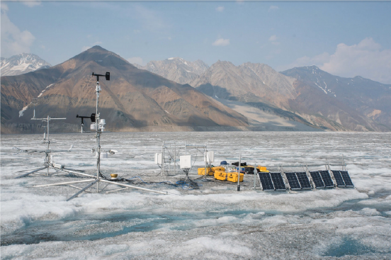
Sensors that measure temperature, precipitation and energy flux installed on the Kaskawulsh Glacier, Yukon.
Research
My research uses computer models and on-the-ground measurements to predict how the mass of glaciers will change in the future. Most predictions for glacial melt rely on temperature index models that are designed for other uses, and have to be calibrated when used on glaciers - calibration which only exists for less than 1% of mountain glaciers around the world. This current type of model makes predictions imprecise, and prevents us from fully understanding how quickly and completely glaciers will melt as climate change continues.
The next step for improving glacial melt predictions is to create a computer model that is not temperature index-based, but physics-based instead. A physics-based model takes into account temperature, precipitation, and energy flux - which is a measure of heat exchange between the glacier and its surroundings. Energy flux equations are better understood for flat, unchanging surfaces like crop fields or grass plains, but work poorly over sloping, varied glacier surfaces. One reason for their poor performance is because the type of winds present in high, mountain glacier environments are vastly different from the wind present in a farmer’s field, for example. Mountainous winds such as katabatic winds, which carry high density air down a slope under the force of gravity, cause turbulence along the glacier surface and greatly disrupt how heat is exchanged with the environment. My research involves better understanding the effect turbulent katabatic winds have on the energy flux of glaciers, and creating models that take these effects into account with the goal of making glacial-melt predictions more precise.
Field work is another big part of my research. To run a physics-based model, we need to collect temperature, precipitation, and energy flux data, which involves delicate instruments placed on the surface of remote glaciers. I’m excited by the variety in my work. Not only do I perform data analysis and run numerical models, but I also get to install, test, and calibrate sensors in the field. Travelling to and from field work always keeps me on my toes.
References
Radić, V.et al. Regional and global projections of twenty-first century glacier mass changes in response to climate scenarios from global climate models. Climate Dynamics 42,37–58 (Jan. 2014).
Munro, D. S. A surface energy exchange model of glacier melt and net mass balance. International Journal of Climatology 11,689–700 (July 2007).
Hock, R. Glacier melt: a review of processes and their modelling. Progress in Physical Geography: Earth and Environment2 9,362–391 (Sept. 2005).
Sicart, J.E., Hock, R. & Six, D. Glacier melt , air temperature , and energy balance in different climates: The Bolivian Tropics, the French Alps, and northern Sweden. Journal of Geophysical Research 113, D24113 (Dec. 2008).
Fitzpatrick, N., Radić, V. & Menounos, B. Surface Energy Balance Closure and Turbulent Flux Parameterization on a Mid-Latitude Mountain Glacier, Purcell Mountains, Canada. Frontiers in Earth Science 5, 67 (Sept. 2017).
Priestley, C. H. B. & Taylor, R. J. On the Assessment of Surface Heat Flux and Evaporation Using Large-Scale Parameters. Monthly Weather Review 100, 81–92 (Feb. 1972).
Barton, I. J. A Parameterization of the Evaporation from Nonsaturated Surfaces. Journal of Applied Meteorology18,43–47 (Jan. 1979).
Radić, V. et al. Evaluation of different methods to model near-surface turbulent fluxes for a mountain glacier in the Cariboo Mountains, BC, Canada. The Cryosphere11,2897–2918 (Dec. 2017).
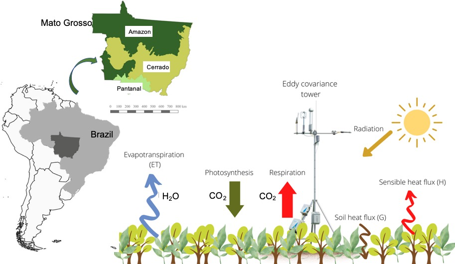
Carbon and water fluxes from different land-uses in the state of Mato Grosso Brazil
Brenda D’ Acunha, PhD Candidate
I have always been interested in the interaction between the atmosphere and the biosphere. I am specially curious about how climate change, deforestation, and land-use change can alter carbon fixation, water fluxes and even regulate the climate. I want to understand these processes, their main patterns, what drives them, how are they changing, and also what we can do to mitigate the impacts of different human activities on the environment. The main challenges I see for climate are turning recommendations into concrete actions and implementation plans. What gives me hope is that UBC has declared that tackling climate change and reducing carbon emissions will be a priority. I also think that it’s good that they are trying to build bridges and encourage dialogue between all the actors, so that proposed solutions include voices from underrepresented communities, and the process is equitable, transparent and just.
Research
My research focuses on studying carbon, water and energy fluxes from natural and managed ecosystems in the state of Mato Grosso (MT), Brazil. MT contains three biomes: The Amazon rainforest to the north, the Cerrado or savanna in the center, and the Pantanal, the world’s largest continuous wetland, to the southwest. Over the last years, the state has turned into the agricultural powerhouse of the country, and now contains about a third of Brazil’s grain production1. However, this rapid growth has led to several impacts on the ecosystems services these systems provide, such as carbon uptake, regulation of the water cycle (i.e. groundwater recharge, evapotranspiration, surface flow), and modulation of regional climate patterns2,3. With my research, I want to understand the main drivers and patterns of carbon and water fluxes from natural (Amazon forest, flooded forest, grassland) and managed (agriculture, pasture) sites within MT. These data are important because they will help to create policies for conservation, but also mitigate the impact of climate change and human activities on these ecosystems.
I also look at how different agricultural land management practices, like the use of biochar (pyrolized organic matter) or agricultural residues as soil amendments, affect carbon, water and energy fluxes, to see if we can find strategies to make agriculture more sustainable, but also more resilient towards climate change.
References
1Woody, K. (2020). Grain and Feed Update. United States Department of Agriculture, Foreign Agricultural Service. Obtained from: https://apps.fas.usda.gov/newgainapi/api/Report/DownloadReportByFileNam…
2Lathuillière, M. J., Johnson, M. S., Galford, G. L., & Couto, E. G. (2014). Environmental footprints show China and Europe’s evolving resource appropriation for soybean production in Mato Grosso, Brazil. Environmental Research Letters, 9(7), 074001.
3Richards, P., Pellegrina, H., VanWey, L., & Spera, S. (2015). Soybean development: The impact of a decade of agricultural change on urban and economic growth in Mato Grosso, Brazil. PLoS one, 10(4), e0122510.
4Simoes, R., Picoli, M.C., Camara, G., Maciel, A., Santos, L., Andrade, P.R., Sánchez, A., Ferreira, K. and Carvalho, A. (2020). Land use and cover maps for Mato Grosso State in Brazil from 2001 to 2017. Scientific data, 7(1), pp.1-10.
How do watersheds regulate the environmental impact of climate change?
Ali Ameli, Assistant Professor
Understanding causes of phenomena has always been the main point of interest in my career. Hydrogeology science provides an opportunity to identify the causes of some environmental disturbances and inform strategies to mitigate their negative consequences.
Despite its high importance, I imagine incorporating actions stemming from community engagement will be challenging. I find the actions taken by communities and different government sectors are sometimes decoupled and even antagonistic. Other action items will have their own challenges as well. What is encouraging however is that academics and communities are becoming more aware of each other's needs.
Research
Climate change is expected to affect most aspects of streamflow. This will impact all sectors of water resource management such as water allocation and security, and flood/drought risk reduction. Without time-and cost-intensive data collection and modelling, it is difficult to predict how sensitive a watershed’s streamflow is to changes in climatic attributes. This uncertainty stems from limited capacity to assess what water storage compartments exist in a given watershed (especially underground), and how they contribute to streamflow, in times of rain or snowmelt abundance and shortage. In general, the ways a watershed stores and generates streamflow determines the sensitivity of the watershed’s streamflow to climate change and identifies how the watershed regulates the impacts of climate change. Changes to the use of land within a watershed (e.g., agriculture, forestry, wildfire) may also alter how a watershed stores water and generates streamflow. The overarching objective of my research program is to advance the scientific knowledge on watersheds storage and streamflow generation processes. The program improves and applies state-of-the-art data science and mechanistic techniques to develop a generalizable framework for extrapolating such scientific knowledge and estimating watersheds sensitivity to climate change and landcover developments, in regions with limited amounts of available data (almost 95% of lands across the globe). This framework will set a hydrological foundation for interdisciplinary and applied research collaboration in Canada and internationally, and provide governments and management authorities with science-based decision-making tools to evaluate and meet water and ecosystem sustainability targets.
References
Ameli, Craig & McDonnell (2015). Are all runoff processes the same? Numerical experiments comparing Darcy-Richards to an overland flow-based approach for subsurface storm runoff simulation, Water Resources Research, 51 (12)
Ameli, Gabrielli, Morgenstern & McDonnell (2018). Groundwater subsidy from headwaters to their parent watershed: A combined field‐modeling approach, Water Resources Research, 54(7).
Ameli, Beven, Erlandsson, Creed, McDonnell & Bishop (2017). Primary weathering rates, water transit times and concentration-discharge relations: A theoretical analysis for the critical zone, Water Resources Research, 53 (1), 942-960.
Ameli & Creed (2017). Quantifying hydrologic connectivity of wetlands to surface water systems, Hydrology and Earth System Science, 21, 1791–1808.
Ameli & Creed (2019). Does wetland location matter when managing wetlands for watershed-scale flood and drought resilience?, Journal of the American Water Resources Association, 55(3), 1-14.
Ameli & Creed (2018). Groundwaters at risk: wetland loss changes sources, lengthens pathways, and decelerates rejuvenation of groundwater resources, Journal of the American Water Resources Association, 55(2), 1-13.
The Canadian-Pacific Robotic Ocean Observing Facility (C-PROOF)
Hayley Dosser, Post-doctoral Researcher
I became an oceanographer by accident; I’m originally from the Prairies! I was working on my MSc in physics, studying fluid dynamics, and looking for ways my research could be relevant to the real world. I met some oceanographers whose work included a focus on climate change and the ocean’s role in the Earth System and I was struck by their passion for what they did; they really felt it mattered and I wanted to be a part of that.
I really like the focus of the UBC Declaration of a Climate Emergency, how it treats climate change as something that touches all areas of our lives and requires solutions that commit to justice for marginalized groups. I think a major challenge is moving from broad areas of action to concrete steps to be taken, and ensuring that those steps go far enough. It can be easy to point to one or two actions as sufficient, but the climate emergency is the defining challenge of our lifetimes - it will require change on a level that we have never seen before. I believe UBC can rise to the challenge, but only if it is treated as an ongoing process of extreme importance. I am hopeful because I see people at all levels engaging seriously in conversations around these challenges and pushing for concrete action. As UBC researchers, we see the impacts of climate change every day in our work, in so many areas. I believe that the UBC community is going to keep demanding change because we know we need it - we know it’s an emergency and we want to face it together!
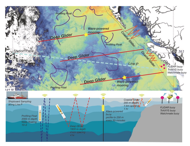
Schematic showing proposed scope of the C-PROOF program. (Top) Sea-surface temperature showing proposed glider monitoring lines (red and orange lines) and wave-powered moorings (yellow stars); sample trajectories of profiling floats (purple lines) and an array of 3 wind and wave buoys (red dots). (Bottom) Not-to-scale side-view schematic showing the typical sampling modes of C-PROOF instrumentation. Operational depths, lateral spacing and repeat times are indicated for each instrument type. Image credit: J. Klymak.
Research
Our oceans are changing at an unprecedented and alarming rate, becoming warmer, more acidic, and more oxygen-limited, with connected and unexpected changes in ocean currents, weather, and marine ecosystems. To quantify and understand the changes and to prepare to adapt to them, we require high-quality, comprehensive observations of the ocean state. However, the oceans are notoriously difficult to sample.
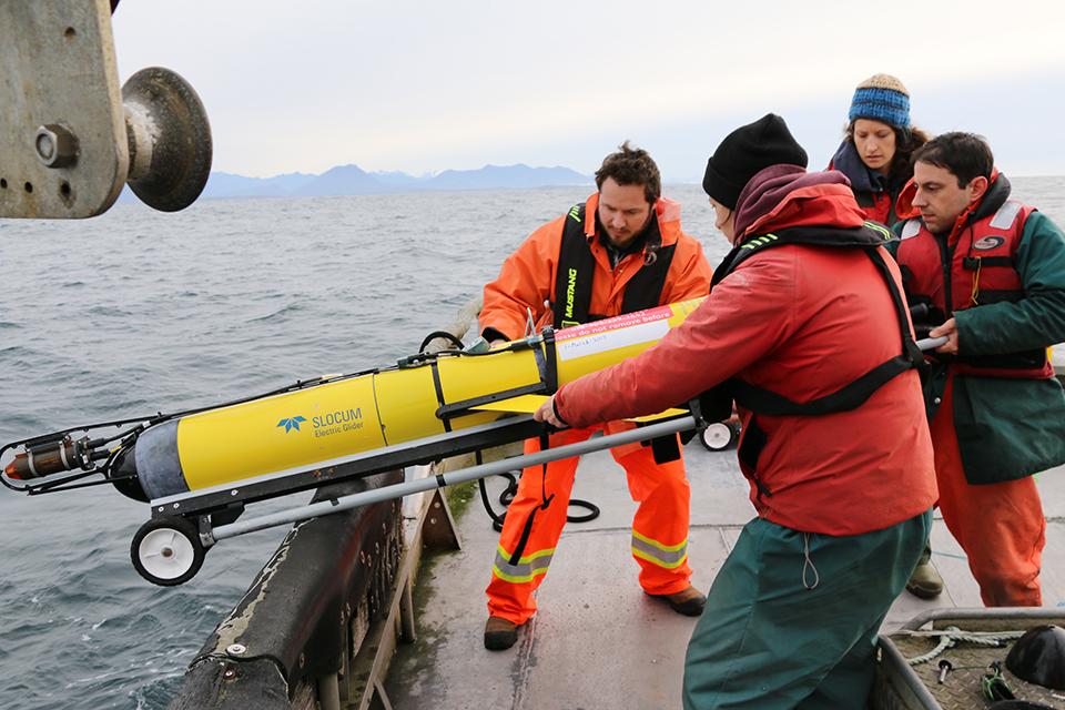
In 2017, a team of oceanographers and ocean engineers from EOAS, the University of Victoria, and Fisheries and Oceans Canada were awarded funds to build a robotic ocean-observing facility to monitor and study BC coastal and offshore waters. We deploy autonomous ocean observing platforms, such as instrumented ocean gliders and profiling floats, to study and monitor BC coastal and offshore waters. These platforms track changes in ocean temperature, salinity and dissolved oxygen, quantify ocean mixing, and measure other biogeochemical ocean properties.
In 2019, C-PROOF achieved the milestone of successfully occupying Line-P, a series of oceanographic sampling stations stretching between the BC coast and Ocean Station Papa - a station in the NE Pacific Ocean that has been routinely sampled by ships since 1959. On its 1400-km journey, the C-PROOF underwater profiling glider “Wall-e” mapped subsurface warmth caused by the recent marine heatwave known as ‘The Blob’. In 2020, the C-PROOF glider “BB” started its occupation of a monitoring line connecting the shallow coastal waters of Queen Charlotte Sound to the deep open-ocean waters beyond the continental shelf, collecting vital oceanographic measurements in the midst of a pandemic. These observations are being used to better understand the mechanisms driving coastal upwelling processes in the region and their important implications for coastal ecosystem health. They will also be used to estimate and explore the ocean carbonate system and ocean acidification in the region.
References
https://www.eoas.ubc.ca/news-events/news/1508310000
https://www.hakai.org/storymap/index.html
https://www.eoas.ubc.ca/news-events/news/1569222000
https://hakai.org/gliding-into-the-deep/
https://hakai.org/bbs-first-mission/
https://hakai.org/what-is-upwelling/
Examining the role of Salpa thompsoni in Southern Ocean biogeochemical processes and food web structure
Alexis Balh, PhD Candidate

I chose to pursue a career in biological oceanography because mitigating the harmful effects of climate change requires honing in on a major player responsible for long-term ocean sequestration: zooplankton. During my masters, I studied environmental science and policy while conducting research on climate change impacts to ocean biogeochemical cycles in earth system models that are utilized by the IPCC for setting global emissions targets. It became clear to me that many models are missing representation of zooplankton processes important for quantifying carbon transport from the ocean surface to the deep. I hope filling this gap will add to a better understanding of how the ocean sink, the world’s largest mitigator of rising carbon emissions, functions so we can prepare for any changes over time.
It will be challenging for UBC to divest from fossil fuels and improve sustainability criteria for investments and assets, though that does not mean it’s not possible. This requires increased transparency from the university administration, acknowledgement of investments and assets that no longer align, which will likely require transitioning away from donors UBC may or may not have a history with. Especially with regard to divesting from fossil fuels, it starts to get political, which will require a ubiquitous commitment on the province level. I am hopeful that UBC can achieve each of the 7 areas outlined in the Declaration and advance the meaning of climate crisis action on all fronts. UBC prides itself on hosting change-makers, an institution sparking innovation fueled by diverse voices, and I certainly believe leveraging these efforts to responsibly combat climate change with a just and inclusive approach is the natural next step. Should the current administration wish to adapt to this changing world and ensure UBC is making the change and not the reason for the harmful change, then it will be done.
Research
My research aims to advance the scientific understanding of ocean processes responsible for transferring atmospheric carbon from the surface layers of the Southern Ocean to the deep where it can reside for long durations of time. This process is known as ocean sequestration, of which the Southern Ocean is most notable, and is especially important for mitigating the effects of rising atmospheric carbon emissions. While ocean mixing plays a large part in this process, research shows that we also have zooplankton to thank1. Therefore, I am focusing on a single zooplankton species, Salpa thompsoni, thought to contribute a large proportion of carbon transfer in the Southern Ocean2. Like other species, Salpa thompsoni, undergoes daily and seasonal migration in the water column, in which it swims to the surface at night to eat and moves back to the depth during the day, otherwise known as active carbon transport3. The uniqueness of S. thompsoni stems from its growing biomass and expansion into territories previously dominated by krill4 (the main prey for many predators, such as whales, penguins, seals, etc.). My goal is to quantify S. thompsoni contribution to passive and active carbon transport and represent the processes in an ecosystem model embedded in a global model, which will be used to predict further expansion and influence on the region’s food web.
I am most excited to contribute to a field of research that will be of benefit to, not only scientists, but to stakeholders mobilizing the science. The results will be utilized by modelers looking to fill data gaps that are essential for predicting, and thus preparing for climate change effects, and fisheries managers that require insight on any changes to the food web to instill conservation efforts. I hope my work can add value in shaping global action and shed light on the importance of all organisms in maintaining a healthy ecosystem.
References
1Atkinson, A., Siegel, V., Pakhomov, E., & Rothery, P. (2004). Long-term decline in krill stock and increase in salps within the Southern Ocean. Nature, 432(7013), 100–103. https://doi.org/10.1038/nature02996
2Gruber, N., Landschützer, P., & Lovenduski, N. S. (2019). The Variable Southern Ocean Carbon Sink. Annual Review of Marine Science.
3Iversen, M. H., Pakhomov, E. A., Hunt, B. P. V., van der Jagt, H., Wolf-Gladrow, D., & Klaas, C. (2017). Sinkers or floaters? Contribution from salp pellets to the export flux during a large bloom event in the Southern Ocean. Deep-Sea Research Part II: Topical Studies in Oceanography, 138. https://doi.org/10.1016/j.dsr2.2016.12.004
4Pakhomov, E. A., Dubischar, C. D., Strass, V., Brichta, M., & Bathmann, U. V. (2006). The tunicate Salpa thompsoni ecology in the Southern Ocean. I. Distribution, biomass, demography and feeding ecophysiology. Marine Biology, 149(3), 609–623. https://doi.org/10.1007/s00227-005-0225-9
Impacts of climate change on marine primary productivity in the northern Pacific Ocean on different time scales
Zhen Li (Amanda), Postdoctoral Fellow
I am interested in the nature process and especially hope to know the mechanism controlling different time-scale climate changes and how the short-term and long-term climate variation could influence an ecosystem including our human’s life in future. Of the 7 areas of action outlined in the UBC declaration of a Climate emergency, the 3rd area is likely to pose as the most challenging. Many people are starting to realize the threats from climate change and are doing their best to influence more people. More policymakers are starting to consider climate issues and young people are understanding and shifting their behaviour towards an action-based climate response.
Research
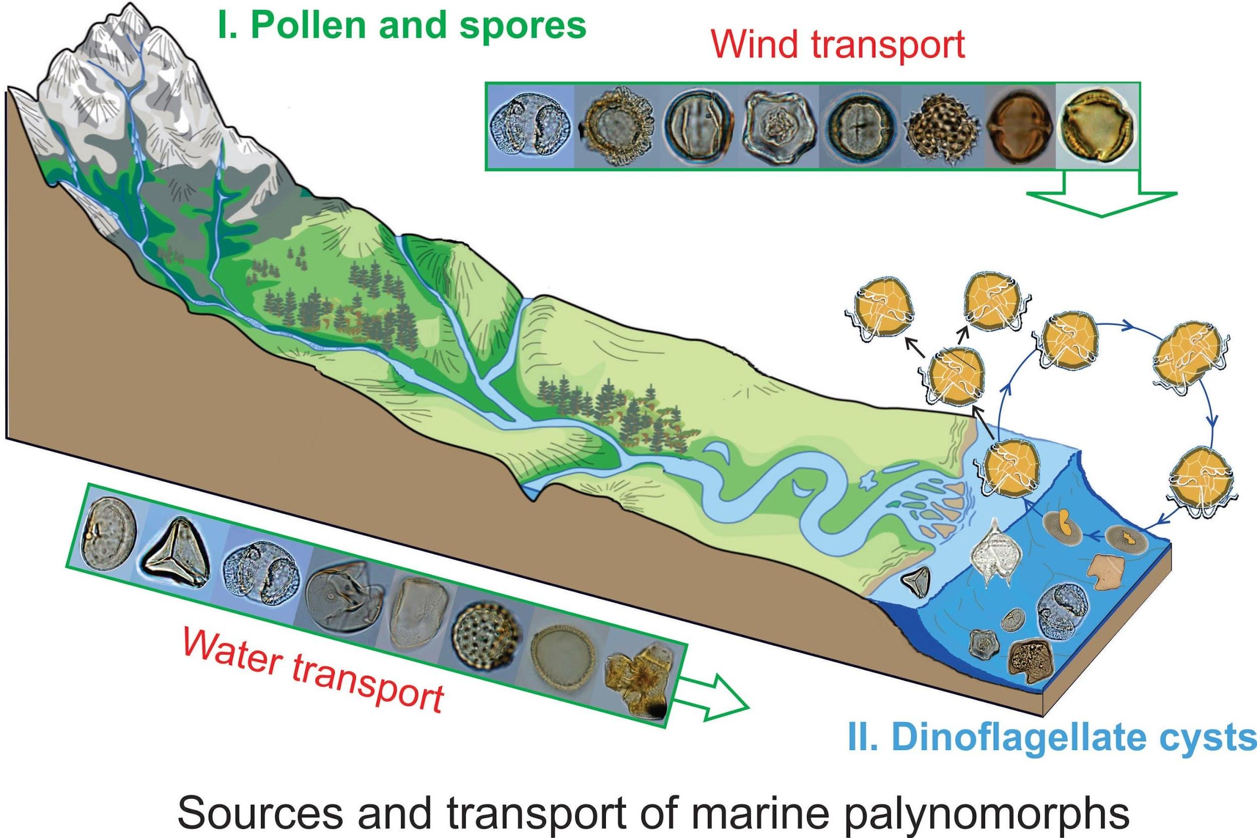
How did climatic change influence primary productivity, and how did the marine ecosystem respond to changes in regional climate and local oceanographic variation? Climate change shows various long-term to short-term periodicities with different driving factors and mechanisms. Understanding climate cycles on various temporal and spatial scales could help us to identify climate mechanisms and their impacts on sedimentary and ecological systems. With this research we may further predict ecosystem and biodiversity response to future hazards associated with climate change and reduce economic losses by making valid strategies for sustainable development. My current research is focused on quantitatively estimating the past oceanographic conditions and the impacts of climate and sea-level change on the planktonic ecosystem on the seasonal to millennial scales. Modern Analogue Technique is used on modern dinoflagellate cysts (rest stages of one of the most dominant groups of phytoplankton) for reconstructing past environmental parameters (e.g temperature). With past environmental parameters established, estimated models can be validated. The validated models are used on the dinoflagellate cyst data of sediment cores from both the east and the west Pacific Ocean for the reconstruction of the primary productivity, sea-surface temperature, salinity, and nutrients in the past. Our estimates of climatic and oceanographic conditions of the northern SCS provided insights into regional climate events in the western low-latitude Pacific Ocean and their impacts on local oceanography and ecology. Time-series analysis allows us to know long-term and short-term climate factors, and correlate the changes in PP with specific factors. The estimated models could also predict the future dinoflagellate assemblages under specific climate scenarios.
It seems to me that research is full of painful and joyful moments. When my experiment results are not as I expected, I feel very frustrated. But such unexpected results might trigger my new ideal or hypothesis which makes me joyful. For me, research always means “new”: new challenges, new findings, new questions, new ideas….no end. This is also the amazing part. The most exciting part of my research is when I find a new species or a rapid change in climatic or oceanographic indicators which is always associated with an interesting story. The micro-story tellers in my research directly tell us the story about climate changes and the history of how they responded to the changes.
Assessing climate-dependent variability in marine primary productivity in the Canadian Arctic Ocean
Robert Izett, PhD Candidate

The ocean and its wildlife have always invoked a sense of awe for me – from family vacations to the beach during my youth, to later living in Victoria, BC where the ocean became so central in my day-to-day life. Now, I recognize the universal connection to the ocean in regulating planetary climate and sustaining the livelihoods and cultural practices of millions of people. This inspires me to seek to understand how and why the ocean is changing under human-induced pressures, and to ultimately advocate for its protection.
As with the national and international climate movements, I see the biggest challenges to UBC progressing on the 7 action items relating to time and money. These items should be acted on immediately by mobilizing the necessary resources, but I see a potential hurdle in a hesitation to do either if UBC’s financial interests end up taking precedence. There are a lot of inspired and inspiring people (including staff, faculty and, perhaps most importantly, students) at UBC and within EOAS – their collective energy, diversity of backgrounds and academic expertise, and passion for fighting the climate emergency give me hope that these key challenges can be addressed.
Research
Microscopic marine plants, called phytoplankton, play a key role in regulating global climate and setting upper limits on oceanic biological carrying capacity. Indeed, through photosynthesis and the subsequent production of organic carbon – a process known as “primary production” (PP) – phytoplankton remove carbon dioxide (CO2) from the atmosphere and nourish larger marine organisms. In the Arctic, the massive summertime bloom in ecosystem productivity is linked to interannual cycles in PP, which, in turn, is controlled by large-amplitude changes in the physical environment. These seasonally productive ecosystems have sustained Inuit livelihoods for thousands of years. Yet, the impacts of planetary warming and receding land and sea ice on the biological productivity of marine waters may be profound and resulting changes to the timing and extent of PP in the Canadian Arctic can have significant implications for food web ecology and the seasonal removal of CO2 from the atmosphere. A key goal of my research is to better quantify and predict the climate-related impacts on marine PP in the Canadian Arctic Ocean.
To achieve these research goals, our group, led by Dr. Phillipe Tortell, employs a range of observational and numerical tools. Through collaborations with researchers at the Department of Fisheries and Oceans Canada, ArcticNet, Université Laval and the Canadian Coast Guard, we deploy a suite of instruments onboard icebreakers to obtain measurements of ocean conditions at high spatial resolution. Combining these data with the output of advanced ocean circulation models produced by Dr. Paul Myers at the University of Alberta, we can derive estimates of marine PP across very broad spatial scales in a conventionally under-sampled ocean region. By examining these trends, we link PP variability to changes in the physical environment, or alterations to other marine processes. Our work, for example, has indicated a strong potential for ice melt from glaciers to elevate marine PP in some regions, while river run-off from vegetated Arctic lowlands may have the opposite effect. These results offer important insights into potential future changes in Arctic PP, particularly as climate change and associated warming and ice retreat is resulting in a rapid acceleration of freshwater loading to the marine system. However, sustained monitoring, facilitated by newer technologies, will be required to evaluate the interannual feedbacks between climate and PP. Through on-going work, we are thus seeking to integrate fully autonomous instrument systems, capable of unattended (i.e. without the need for human oversight) PP measurements, into existing scientific infrastructure. This endeavour represents an exciting opportunity to significantly expand the coverage of PP observations so that climate-dependent changes in its variability can be examined over even broader space and time scales. .
The Birth, Life and Death of Boundary Layer Clouds
Philip Austen, Associate Professor
I am a cloud physicist from Seattle, Washington. I was a physics major interested in environmental problems, and did a summer internship at Woods Hole Oceanographic Institute involving ocean acoustics. Based on that experience, I started graduate school in oceanography at the University of Washington, but midway through my first year I attended a seminar by Marcia Baker on clouds and climate. Her presentation was compelling enough to get me to switch from oceanography and join her cloud physics group.
I think the major challenge facing climate progress will be managing the transition to a carbon neutral economy in a way that raises the standard of living for median-wage workers. Without a positive vision, building a large enough coalition to produce economic changes of the magnitude required is not going to happen. The fact that the United Steel Workers union has joined the BlueGreen Alliance is an example of the kind of coalition building that will determine whether we succeed or fail at implementing policies like the Evergreen Action Plan.
Sketch2 of three different ways boundary layer clouds in current climate models respond to a warming climate: 1) increased cloud cover (stabilizing feedback) 2) reduced cloud cover (amplifying feedback) 3) cancellation (neutral feedback).
Research
The fact that different climate models produce different 50-year forecasts given the same emission scenarios is due largely to differences in the way these models represent clouds, which transport energy and moisture, reflect sunlight and emit longwave radiation back to space1. My research has focused on how clouds mix with their environment and the impact of that mixing on the microphysics (droplets and ice crystals), dynamics (updrafts and downdrafts) and bulk properties (cloud thickness and cloud fraction) of shallow clouds2,3. These boundary layer clouds play a major role in reflecting sunlight over the dark ocean (hence cooling the planet) and transporting energy and moisture into the tropics, where deep convection drives the global atmospheric circulation. They are too thin and too small to be resolved by any climate model, so their behavior has to be “parameterized”; that is, linked to large-scale features that climate models do resolve, such as the average vertical profile of temperature and moisture or the wind speed and direction. The condensation of water vapor into cloud droplets happens in an instant, releases a large amount of thermal energy and produces millions of reflecting and emitting surfaces that completely change the optical properties of the atmosphere. My colleagues and I use detailed computer models of clouds to help bridge the gap between fine scale cloud features and their unresolved effect on the large-scale properties of the atmosphere.
Over 80% of the energy of the atmosphere is transported in the form of water vapor and released in cloudy updrafts. Water vapor is also the dominant greenhouse gas, and clouds determine the strength of the water vapor greenhouse effect by mixing vapor throughout the atmosphere, and removing it via precipitation. The tight coupling between clouds and the global energy and moisture budgets of the atmosphere and ocean, mean that it is extremely hard to develop any intuition about the final effect of all these feedback loops – the history of cloud/climate research over the past forty years has been full of surprises.
References
1Zelinka et al., 2020: Causes of higher climate sensitivity in CMIP6 models, GRL, 10.1029/2019GL085782
2Zhang et al., 2013: CGILS: Results from the first phase of an international project to understand the physical mechanisms of low cloud feedbacks in single column models, JAMES, 10.1002/2013MS000246
3Dawe,J. T. and P. H. Austin, 2013: Direct entrainment and detrainment rate distributions of individual shallow cumulus clouds in an LES, Atmos. Chem. Phys. 10.5194/acp-13-7795-2013
Atmospheric waves and weather extremes
Rachel White, Assistant Professor
I became an atmospheric scientist for two reasons – I find the dynamics of the atmosphere beautiful and fascinating; and also because climate change is one of the biggest challenges humans as a species will face in the coming decades, and I want to work on something that can help with this.
One of the biggest challenges we face in making progress is that humans are typically not very good at thinking and planning long-term, so actions that cost us now (whether that’s a financial cost, resource or time) but for which we will see the benefit in 30-50 years, are easy to postpone. Also our society is typically centered around a belief that things ‘making money’ = success, and typically the people making decisions have succeeded in this system and so are more likely to believe in it. So we collectively struggle to take actions that will be less profitable in the short term (e.g. divesting from fossil fuels) even if we know that it will benefit all of us in the long term.
There is so much more movement on this issue now, nationally and globally – this is a constant conversation, not something that appears every time there is a catastrophic weather event but then disappears again a few weeks afterwards. And this continuous movement and pressure on our leaders and our politicians is working to bring about changes in policy and behaviours – we just have to keep building up momentum.
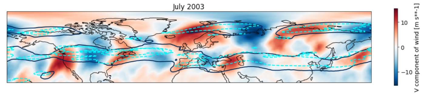
This figure shows the atmospheric circulation in July 2003, when there was a record-breaking heatwave over Europe, resulting in the deaths of an estimated 70,000 people. The colours show meridional (north-south) winds: Rossby waves can be seen as consecutive regions of northward (red) and southward (blue) winds. While Rossby waves are common in the atmosphere, they usually move from west to east and we experience them as transient weather systems – what was unusual in July 2003 was that this wave was so strong, and stayed approximately in one place for so long (several weeks), that it can be seen in the monthly mean values shown above. This contributed to the extreme heatwave in Europe, as well as other extreme events around the world. The black and cyan contours indicate the presence of ‘atmospheric waveguides’ – my research looks at how these waveguides may influence the Rossby waves and contribute to these extreme events.
Research
Extreme weather events, including heatwaves, cold snaps, droughts and flooding, have a devastating impact on humanity, but there are still large uncertainties in how these might change in intensity and frequency with human-caused climate change. In 2017 British Columbia experienced a record-breaking wildfire season driven by unusually hot and dry weather; the burnt area was estimated to have been increased by a factor of between 7-11 by anthropogenic climate change. Many extreme weather events are associated with wave patterns known as Rossby waves in the large-scale atmospheric circulation. My research aims to better understand how such large-scale patterns increase the probability of extreme weather. This includes the research questions:
How will changing circulation patterns in the next 100 years affect the intensity and frequency of extreme weather events?
How well can we predict the probability of extreme weather 1-3 months in advance? Can large-scale atmospheric patterns help improve our predictions?
My overall goal is for my research to help reduce the impact of future extreme weather events.
Honey as a biomonitor for urban metal distribution
Kate Smith, PhD Candidate and Environmental Chemist

I became an environmental chemist because I am interested in how built environments - especially cities - affect the (bio)geochemical cycling of chemicals like heavy metals, PAHs, PCBs, pesticides, and pharmaceuticals. I believe the main challenges hindering climate action and environmental justice are rapid urbanization and population growth, human displacement due to climate change, and health inequalities. I have hope for climate progress, especially when I see increased funding for environmental and climate research, greening initiatives in cities such as city gardens and careful monitoring of new and legacy pollutants, improved ‘ecodensity’ in cities that maximize space for housing and improve transit systems, and environmental education and outreach, especially for pollutants such as lead (Pb).
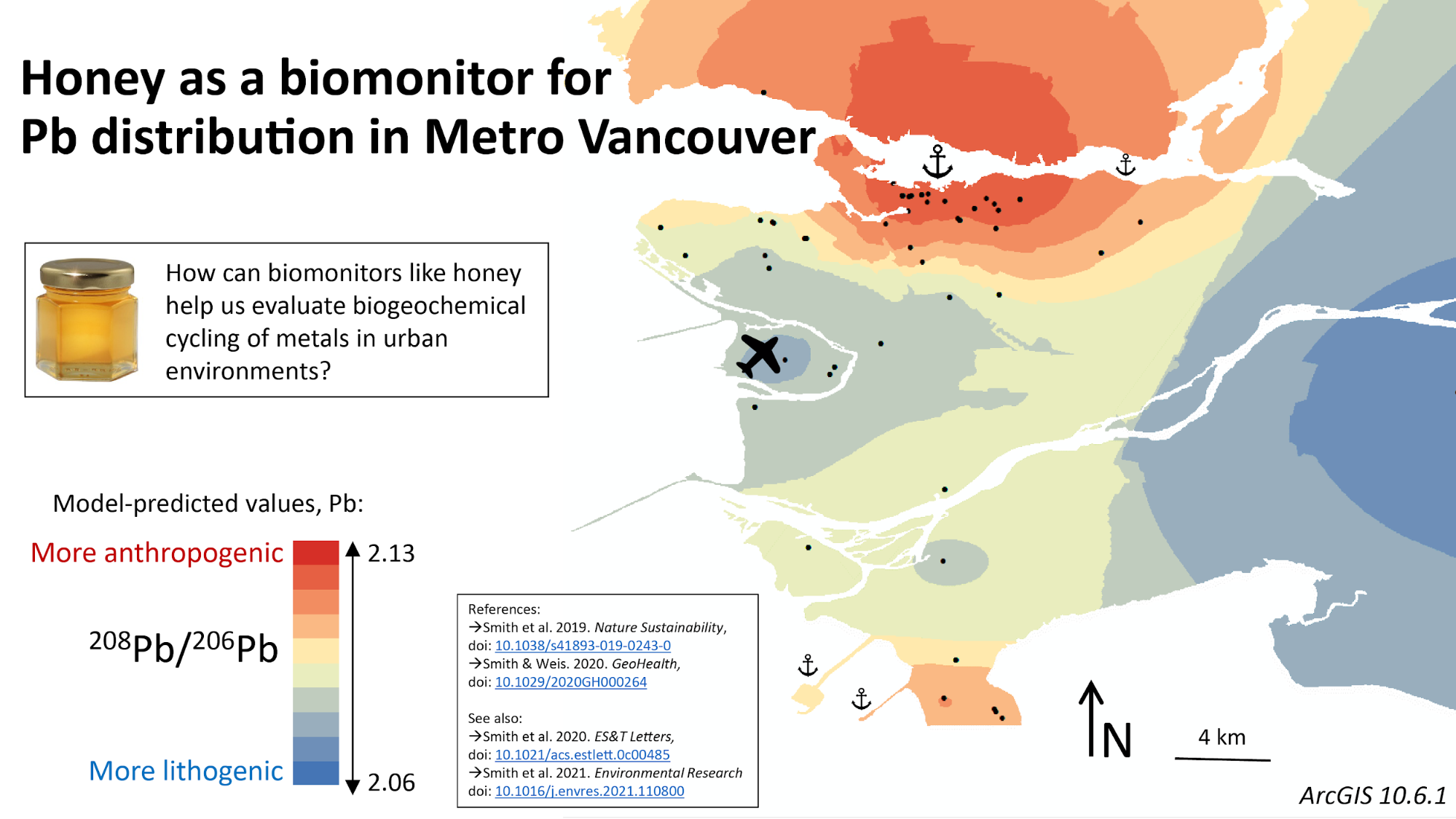
Research
My research explores the impacts of pollution in cities using honeybees as biomonitors. Trace element and isotopic compositions of honey samples (and other bee products) from Metro Vancouver provide chemical snapshots of ~2 km-diameter regions (the range of a typical honeybee). Thus, we can assess small-scale variations in certain elements, and their isotopes, of particular interest to pollution processes. This work is relevant to current critical environmental and agricultural concerns, including climate change (especially in coastal cities), sustainability, food safety, declining pollinator populations and rapid urbanization. The relative affordability of honey sampling and analysis makes this work ideal for adapting and implementing in other cities around the world.
References
Smith, K.E., Weis, D., Amini, M. et al. Honey as a biomonitor for a changing world. Nat Sustain 2, 223–232 (2019). https://doi.org/10.1038/s41893-019-0243-0
Smith, K.E. and Weis, D. 2020. Evaluating spatiotemporal resolution of trace element concentrations and Pb isotopic compositions of honeybees and hive products as biomonitors for urban metal distribution. GeoHealth, 4, e2020GH000264.
Smith, K.E., Weis, D., Chauvel, C., and Moulin, S. 2020. Honey maps the Pb fallout from the 2019 fire at Notre-Dame Cathedral, Paris: A geochemical perspective. Environmental Science & Technology Letters, 2020, 7, 10, 753-759.
Smith, K.E., Weis, D., Scott, S.R., Berg, C.J., Segal, Y., and Claeys, P., (2021) Regional and global perspectives of honey as a record of lead in the environment, Environmental Research,195.
Application of trace metal concentrations and lead (Pb) isotope ratios in different spatial and temporal settings: Geochemical variation in three environments
Brooke Hoppstock-Mattson, PhD Student, Geochemist
I am fascinated by how living things and their by-products can capture chemical changes in their habitats. Biomonitoring is “use of organisms/materials to measure to obtain quantitative information on certain characteristics of the biosphere” (AL-Alam et al., 2019). Metal contaminants can have a pernicious effect on nature and tend to exist for a long time once they have been released into the environment by industrial processes. Before arriving at UBC I had the opportunity to explore how collected moss from near a mining site in remote northwestern Alaska reflected the deposition of ore dust from the transport of mined materials. In this work, I was able to examine the variation of Pb isotopes and correlate the isotopic trends with concentrations of indium and bismuth throughout the study area. This opened my eyes to how biomonitoring allows us to sample large areas throughout time with relatively low costs.
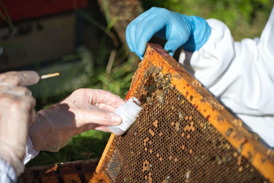
Sampling honey for the COVID-19 lockdown study at the UBC Orchard beehives
Research
My work often relates to tracing and monitoring the aftermath of various industrial activities. The novel use of metals, and specifically isotope systems, is on the rise and will be a powerful tool in helping us understand how metal pollutants behave in earth’s natural systems. I am hopeful about the use of geochemical tracers as a tool for monitoring large areas for relatively low cost over long periods of time. As we continue to refine this tool, we hope that it can be applied to a diverse range of environments to answer environmental, geological, or biological questions.
Environmental monitoring is a key facet to conservation and management of anthropogenic activities that can affect nature. Through my current work, I am developing this geochemical tool and testing its efficacy in a three-pronged approach using biomonitors. The primary goal of my project is to further develop Pb isotope ratios and trace metal concentrations as environmental monitoring tools.
The first approach builds upon previous work with honey and bee tissue that has been done to assemble an atmospheric geochemical map of Vancouver using hives throughout the metropolitan area. I have analyzed honey and bees from 2020 and 2021 to determine if we can detect acute changes in atmospheric metals as the result of the COVID-19 lockdown and general shifts in traffic patterns. The Vancouver, Canada, honey will be compared to honey collected during lockdown in Brussel, Belgium, to examine differences between cities with different Pb histories and transit patterns. The second portion of my thesis involves quantifying geochemical differences between Pacific chum salmon from different stocks, specifically contrasting Asian and North American stocks. And lastly, I will be measuring Pb isotope in bowhead whale baleen plates from the Hudson Bay to try resolve a pre-industrial or less anthropogenically influenced Pb isotope ratios from the baleen plates. This would be an excellent tool to apply to environments where lead has been ubiquitous since industrialization. Understanding the limits of these methods in various settings of time and space will help scientists apply the tools better to their own work.
Related Projects
Zhou et al. (2018) Env. Sci. & Tech. 52 991-1001;
Smith et al. (2019) Nat. Sustain. 2 223-232;
Li et al. (2020) Anthro. 29 100234;
Smith and Weis (2020) GeoHealth. 4;
Smith et al. (2020) Env. Sci. & Tech. 7 753-759;
Smith et al. (2021) Env. Res. 195 110800
Carbonation of the Oman Ophiolite during subduction and emplacement
David Zeko, MSc Candidate
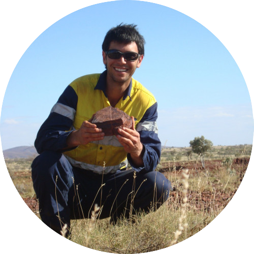
I became a geological scientist to pursue a career where I could follow my curiosity and sense of adventure. I love being outside, learning about the natural world, and visiting new places. One of the main challenges I see towards climate progress is fossil fuel powered transport: the study of geology inherently involves a large amount of travel, often to remote places accessed by aviation. I have hope for progress because of the availability of carbon offsetting schemes and a decision-making framework that considers the need to fly - small changes in the propensity of each person to travel can amount to a significant change collectively.
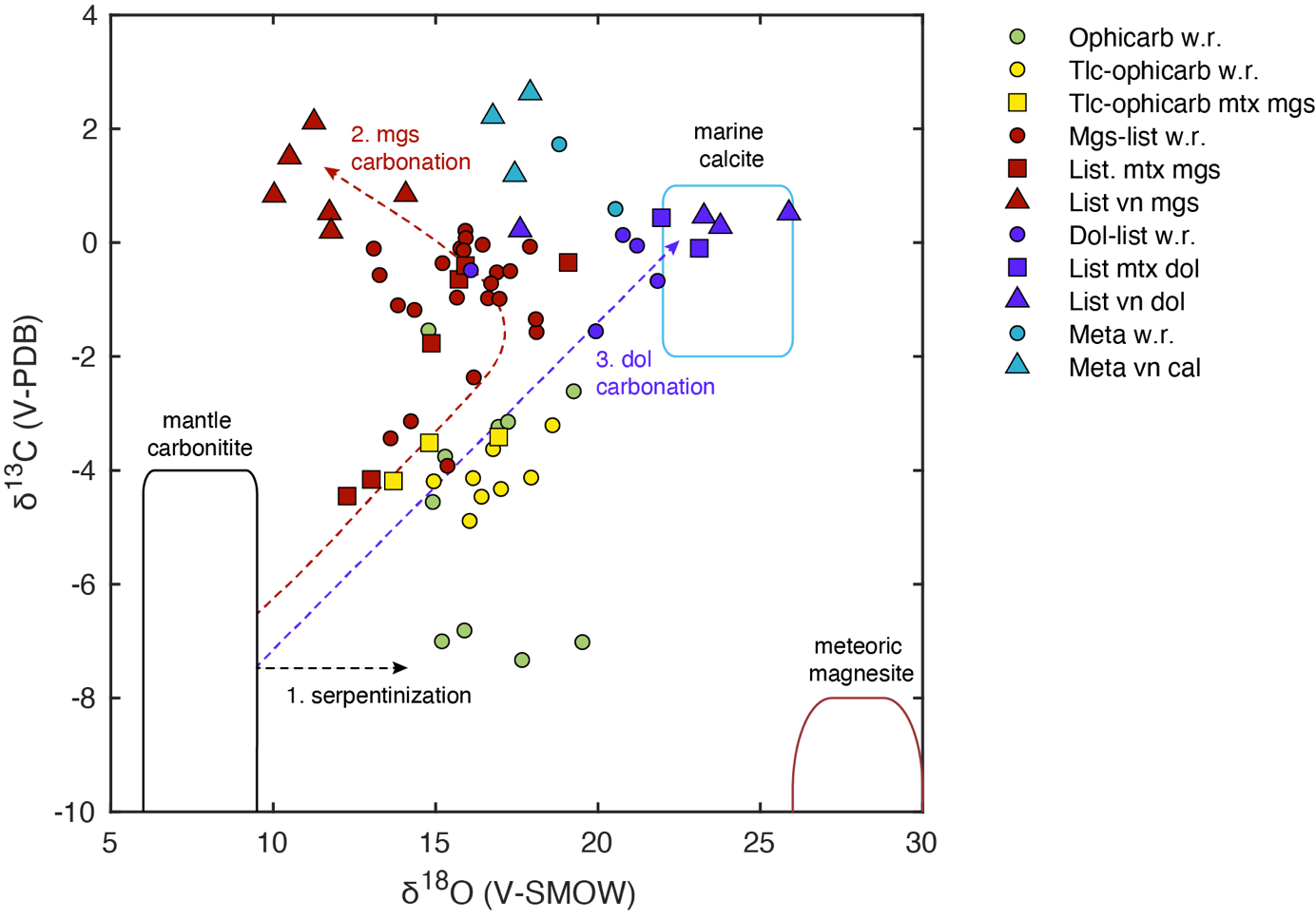
Stable carbon and oxygen isotope values of carbonates labelled by rock type (symbols) and compared to other carbonates (fields). Green denotes serpentinized and partially carbonated mantle rocks (ophicarb) while maroon and purple denote the fully carbonated mantle rocks known as listvenite (list). Progressive carbonation results in the dilution of the mantle carbon isotopic signature (green circles with negative values) by the marine calcite signature (blue circles and triangles with low positive values). Isotopes also indicate that the underlying metamorphic rocks (meta) are a likely source of the carbon dioxide. The field for meteoric and cryptocrystalline magnesite is from Quesnel et al. (2013), mantle carbonatites from Deines (2002) and marine calcite from Qing and Veizer (1994). w.r = whole-rock, mtx=mgs and vn = vein.
Research
Ultramafic rocks are rich in metals such as magnesium and iron and have the ability to absorb large amounts of carbon dioxide by forming stable carbonate minerals such as magnesite. In the Sultanate of Oman, ultramafic rocks that formed deep below oceanic crust were tectonically thrust onto land. During this process, billions of tonnes of carbon dioxide was sequestered through mineral carbonation. My research shows that mineral carbonation in Oman proceeded via a series of chemical reactions that broke down minerals in the oceanic crust, such as olivine and orthopyroxene, to form new minerals such as talc, magnesite and dolomite. These reactions were driven by two pulses of carbonating fluids that originated from carbonate-bearing metamorphic rocks immediately below. The carbonating fluids varied in temperature between 50 and 250 ℃ and contained upwards of 0.01% carbon dioxide. These conditions could be replicated in engineered mineral carbonation systems to sequester CO2.
References
Deines, P. (2002). The carbon isotope geochemistry of mantle xenoliths. Earth-Science Reviews, 58(3), 247–278. https://doi.org/https://doi.org/10.1016/S0012-8252(02)00064-8
Qing, H., & Veizer, J. (1994). Oxygen and carbon isotopic composition of Ordovician brachiopods: Implications for coeval seawater. Geochimica et Cosmochimica Acta, 58(20), 4429–4442. https://doi.org/https://doi.org/10.1016/0016-7037(94)90345-X
Quesnel, B., Gautier, P., Boulvais, P., Cathelineau, M., Maurizot, P., Cluzel, D., Ulrich, M., Guillot, S., Lesimple, S., & Couteau, C. (2013). Syn-tectonic, meteoric water–derived carbonation of the New Caledonia peridotite nappe. In Geology (Boulder) (Vol. 41, Issue 10, pp. 1063–1066). Geological Society of America, Inc. https://doi.org/10.1130/G34531.1
Constraining the sensitivity of landscapes, surface processes and terrestrial sedimentary archives to past climate changes
Mitch D’Arcy, Assistant Professor

I am a geomorphologist and assistant professor from London, England. I became a geomorphologist so I could address fundamental geoscience questions that span the disciplines of plate tectonics, climate science, and palaeoclimate, and involve a range of methods including field-based mapping and geomorphology, theoretical models, geochemistry, and remote sensing. My primary aim is to understand how climate changes in the past have impacted Earth’s surface processes, landscapes, and terrestrial sedimentary deposits.
Research
My research aims to understand how past climate changes have affected Earth’s surface. I focus on constraining how sediment production, transport and deposition have reacted to changes in hydroclimate associated with Earth’s orbital cycles. The influence of climate on surface processes has important implications for our understanding of how sensitive landscapes are to climate change, how palaeoclimate signals get transmitted into stratigraphic archives, and how we can use sedimentary records to reconstruct Earth’s past climate states.
Earth’s climate has changed throughout its history, over many different timescales and in a variety of ways. It’s exciting to be able to read geological records of Earth’s evolution, and I find ancient climate changes particularly fascinating. It’s important that we have a strong, fundamental understanding of ancient climate changes and their consequences for the Earth’s surface. These events offer clues about how anthropogenic climate changes in the future could impact the landscapes we live and depend on.
Climate change and human diet in prehistory
Kendra Chritz, Assistant Professor
I have always been curious and I love learning about the deep history or inner workings of things. I got hooked on geochemistry and paleoecology while during a summer research project in undergrad in Ireland on an extinct Ice Age mammal called the Irish elk (a deer with a 3.5 m antler span). I love that we can use chemistry to go back in time and learn about the lives and environments of long dead or even extinct creatures.
Climate change is an overwhelming crisis that can often lead to a feeling of powerlessness. I hope that we can stay committed and focussed to the task ahead as each year comes with more pressing climatic and environmental challenges. I remind my students of this a lot: when groups of people have a will to change or a collective goal, we are able to accomplish remarkable things. We’ve solved some tremendous environmental crises on this planet, and we can do it again if we’re willing to.
We sample past diet by analyzing the chemistry of teeth. The carbon in your teeth comes from the food you eat (“you are what you eat”), so by analyzing this carbon, we can tell what ancient people and organisms ate. Some of these teeth, like this baboon tooth, are small and delicate, so we shoot the enamel with a laser and analyze the carbon in the gas that comes from the laser shot (the bright white light you see).
Research
The switch from foraging and hunting for wild food to making our own food through domesticated crops and animals is one of the biggest technological innovations in human history. This change in our diet allowed us to develop into the global, urbanized modern world we now live in, and yet we still don’t fully understand how and why it happened. We know that in some places of the world, like Africa, the switch to food production was caused by a big climatic change that happened between 10 - 5,000 years ago, when the climate went from rainy to dry. This diet switch also accompanied other changes, like building ritualistic architecture (like Stonehenge), changing our environment for our purposes, and living most of our lives in one place with lots of other people (sedentism, urbanism). Understanding the close connections between the way we live and how climate change shaped us in the past will help us understand how we might cope with our next coming climatic change, and how we might respond this time around.
I love reconstructing past worlds, especially the world's people like us used to inhabit. This work gives us a little glimpse into how we responded to large scale climatic change once before and how that change shaped modern society. I think understanding how we got here will help provide the context for our current climate crisis. One thing is certain: we are very adaptable and capable of making big changes when faced with environmental challenges.
Earth's tectonic climate control
Mark Jellinek, Professor
I became a scientist because of a passion to understand, grow through the process, teach what I learn, and to enable growth as a result. A main challenge towards progress on 7 areas of action outlined in the UBC Declaration of a Climate Emergency is the initiative for the university to act. Because progress starts only with a decision to evolve.
Research
One of the most astonishing chapters in Earth’s history is “Snowball Earth”: The twice entombing of the whole planet beneath a kilometer-thick layer of ice for tens of millions of years. More improbable still is that the end of the last episode around 635 million years ago somehow helped to spark the rise of the diversity of complex animals and land plants along with the high atmospheric oxygen levels that define the modern world. Surprises were not, however, limited to the biosphere. Through the snowball episodes, Earth’s average global climate switched sharply in character from a relatively warm and ice-free world of the previous billion years to one akin to present day, marked by glacial cycles, dynamic ice sheets and profound climate variability of varying intensity over time scales ranging from years to millions of years. How did Earth’s climate become so cold after being warm for so long? Why did consequent global glaciations persist for tens of millions of years and why were there two episodes? What triggered snowball Earth in the first place and how did Earth eventually escape this climatic death sentence? Why is Earth’s current climate so nervous—so sensitive to, for example, anthropogenic sources of CO2. My work explores how effects of plate tectonics including the intermittent formation and fragmentation of supercontinents modulates the major volcanic and weathering controls on Earth’s average climate, setting the stage for protracted periods of warmth, for variability akin to present day and for snowball Earth. Unraveling the particular reasons for Earth’s remarkable and enigmatic climate resilience is simply inspiring: How has Earth maintained a stable, clement climate over its history while neighboring planets Mars and Venus have each gone through different forms of climate collapse? Earth’s current sensitivity to human-controlled CO2 emissions to the atmosphere is a relatively new feature in Earth climate history: Earth was both warmer and less prone to climatic mood swings around 2 billion years ago when the sun was considerably weaker. Why does anthropogenic climate change occur at all?