News
Stay up-to-date with what's happening in EOAS
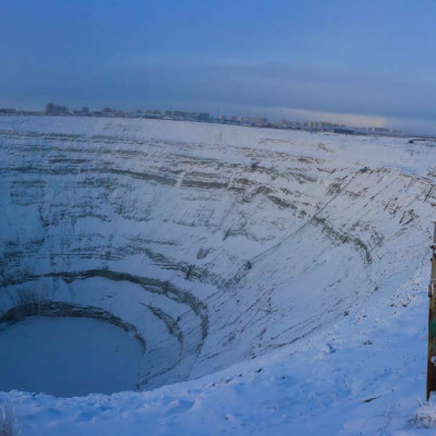
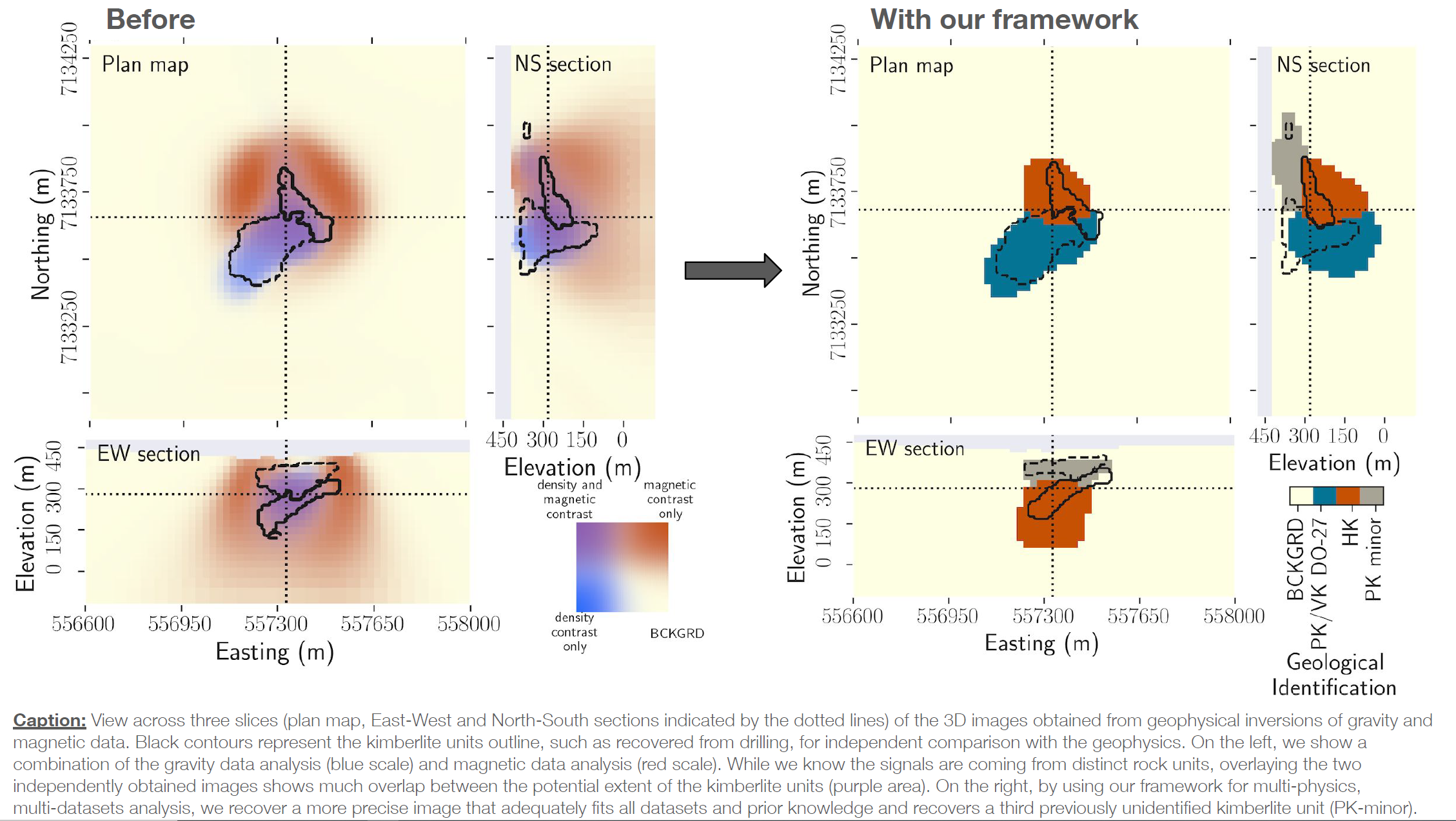
Uncovering the subsurface by merging physics and geology with data science: A diamond exploration study
Thibault Astic, Dominique Fournier, and Doug Oldenburg
The DO-27 kimberlite pipe is a geologic structure located in the Northwest Territories, Canada. Two known kimberlite facies are found within the pipe: one is diamondiferous and characterized by a low-density while the other is magnetic but sterile. They respectively produce gravity and magnetic anomalies that can be measured remotely and used to image the subsurface and map underground resources through a mathematical process called inversion. When multiple surveys with different physics are collected over the same area, combining them in a coherent interpretation can be complicated by apparent inconsistencies between the inversion results from each method due to the lack of integration. Our novel inversion framework, which merges physics simulation with data science, overcomes those issues by performing multi-physics analysis that incorporates petrophysical and geological information, thus making a step forward bridging geology and geophysics. By jointly analyzing the gravity and magnetic responses produced remotely by the pipe, We improved the delineation of the 3-D subsurface structures of the two known kimberlite facies and located a third previously unidentified facies. Those new tools are highly flexible, making them suitable for many problems related to estimating the resources available for a sustainable future, such as minerals, water, and carbon sequestration capacity.
Day(s) in the Life - Yayla Sezginer and Katrina Schuler
Join UBC Oceanography graduate students Yayla Sezginer and Katrina Schuler for a second of every day during their recent research cruise in the Arctic.
Meet Shandin Pete - Hydrogeologist and Science Educator
Dr. Shandin Pete was raised in Nłq̓alqʷ (“Place of the thick trees”, Arlee, Montana). His mother is from the Bitterroot Band of Salish in Montana and his father is Diné from Beshbihtoh Valley in Arizona. He is a hydrogeologist and science educator with interest in Indigenous research methodologies, geoscientific ethnography, Indigenous astronomy, social-political tribal structures, culturally congruent instructional strategies, and indigenous science philosophies. Most of his work in recent years has focused on community engagement to understanding shifts in an Indigenous paradigm of research for science knowledge production. This work has included extensive collaboration with tribal knowledge holders across Native communities and Indigenous academic scholars at institutions nationally and internationally.
Meet Maite Maldonado - Oceanographer
Maite is an oceanographer who specializes in marine phytoplankton and the role that natural & human-produced trace metals play in their population levels. Phytoplankton may be microscopic, but on an annual basis, they convert around 45 gigatons of carbon dioxide to organic carbon, which is roughly half the total carbon fixation on the planet! She also studies how much of that converted carbon then sinks into the deep ocean (and how that sinking process happens). However, not all parts of the Earth’s oceans are equally vibrant with microbial life. Maite has studied which areas are more productive, and why, putting her on the front lines of our understanding of climate change.
Meet Ross Beaty - Geologist
Throughout his 47-year career, Ross Beaty has been a leader in the international mining and renewable energy industries, making a significant and lasting impact in BC and around the world. Driven by his passion for people, communities, and nature, he has brought together the worlds of mining and environmentalism to demonstrate that mining and environmental protection are not incompatible.
After graduating from the University of British Columbia in 1979 in geology and law, Ross began a geological contracting company, Beaty Geological, which he operated from 1980 through 1987. In 1985, Ross established Equinox Resources, a public exploration and gold mining company. In 1994, Ross sold Equinox and founded Pan American Silver. Based in Vancouver, Pan American is now one of the world’s largest silver mining companies with 10 operating mines in the Americas and over 12,000 employees. Between 1994 and 2017 Ross founded 11 other mineral exploration companies and a renewal energy company that has become one of Canada’s largest independent power producers. In 2018, Ross began Equinox Gold, which now operates eight mines in the Americas with over 6,000 employees.
Through all his endeavours, Ross has been committed to sustainable development and high standards of environmental, social and governance practices. Ross’s professional accomplishments are matched by his philanthropic efforts. In 2007 he established the Sitka Foundation with a mission to protect the environment and promote biodiversity. The Foundation partners with more than 70 Canadian and global environmental organizations focused on land conservation, education, scientific research and public policy in support of protection of the environment.
Deploying ocean-bottom seismometers to study the Queen Charlotte Fault
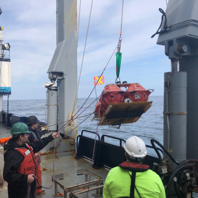
In the summer of 2021, EOAS Ph.D. student Geena Littel and her supervisor Michael Bostock participated in a research cruise offshore, during which they deployed ocean-bottom seismometers (OBS) offshore the Alaskan panhandle. The work was part of a US-Canada collaborative project to study the Queen Charlotte Fault, which runs offshore Haida Gwaii and extends up to Alaska. The fault system represents the largest seismic hazard to southeastern 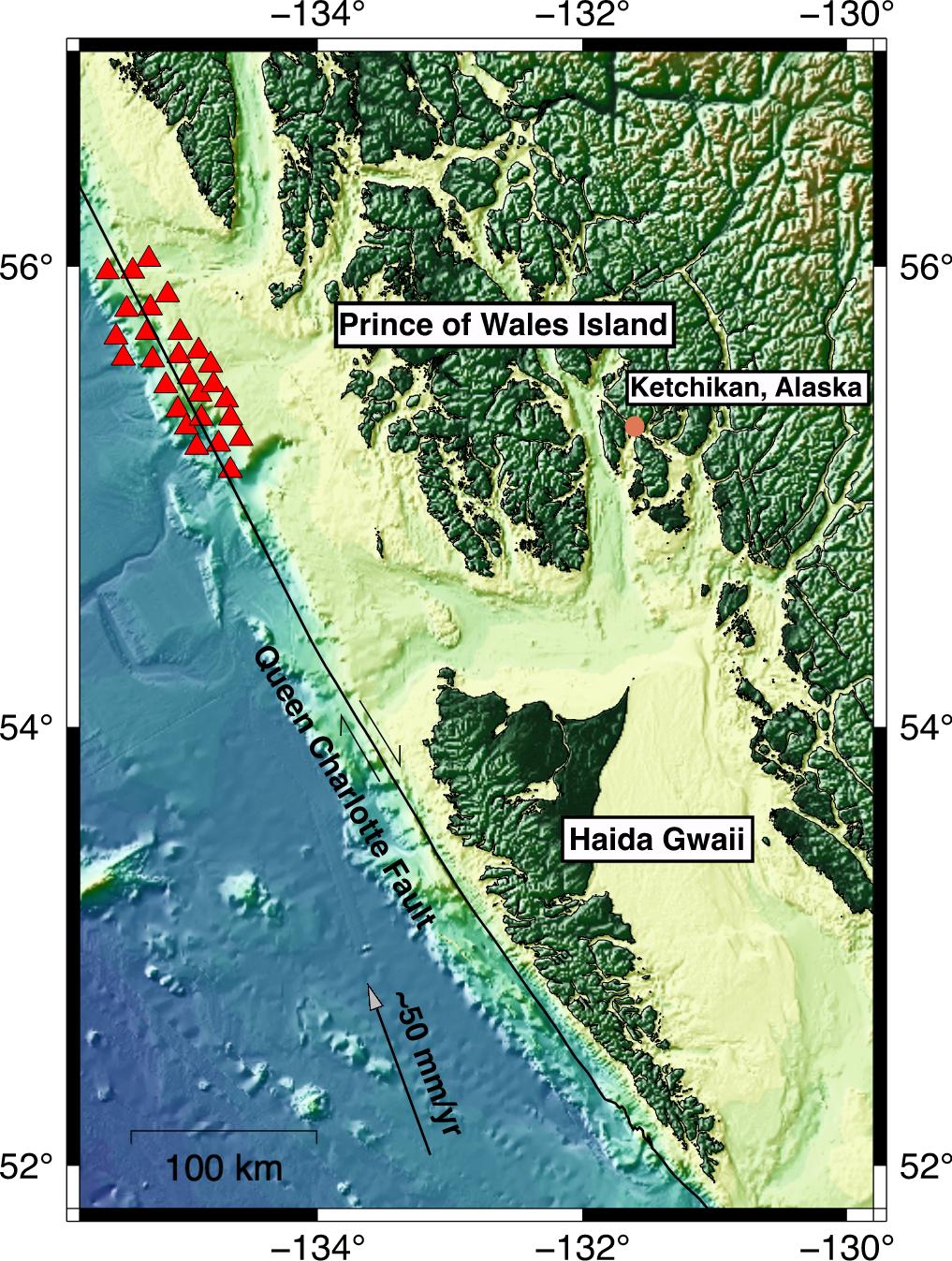 Alaska and Canada outside of Cascadia, and in-depth characterization of it will provide a better understanding of the system and insights into hazard assessment and earthquake forecasting.
Over the course of the 10-day research cruise, the science team and technical OBS team deployed 28 ocean-bottom seismometers offshore Prince of Wales Island, Alaska (see map). They worked around the clock to make sure the instruments were deployed in a timely manner. The OBS will stay out for a year recording earthquakes until next year when the researchers will go back to retrieve them.
The research team set sail from Ketchikan, Alaska and returned to port in Seattle, WA on board the Marcus G. Langseth ship. Before they boarded the ship, it was out with a team of scientists and crew who collected multi-channel seismic data along the fault. Multi-channel seismic data acquisition involves using air guns that are towed behind the ship and generate large sound bubbles as the ship moves. These waves propagate through the water and upper crust and are then recorded by sensors towed along by the ship. This allows scientists to generate images of the structure of the upper crust of the oceanic seafloor.
The goal of the project is to study variations in structure along the Queen Charlotte Fault and the relationship with variations in earthquake behavior along the fault. The project was known as TOQUES: Transform Obliquity of the Queen Charlotte Fault and Earthquake Study. This is because the Queen Charlotte Fault becomes progressively more oblique at an angle to the orientation of the prevailing plate motions as one moves from the north along Alaska to Haida Gwaii, where it is the most oblique. This obliquity has caused a large magnitude 7.8 thrust earthquake in 2012 offshore Haida Gwaii. You can visit this website to learn more about the project: https://qcfhazards.net
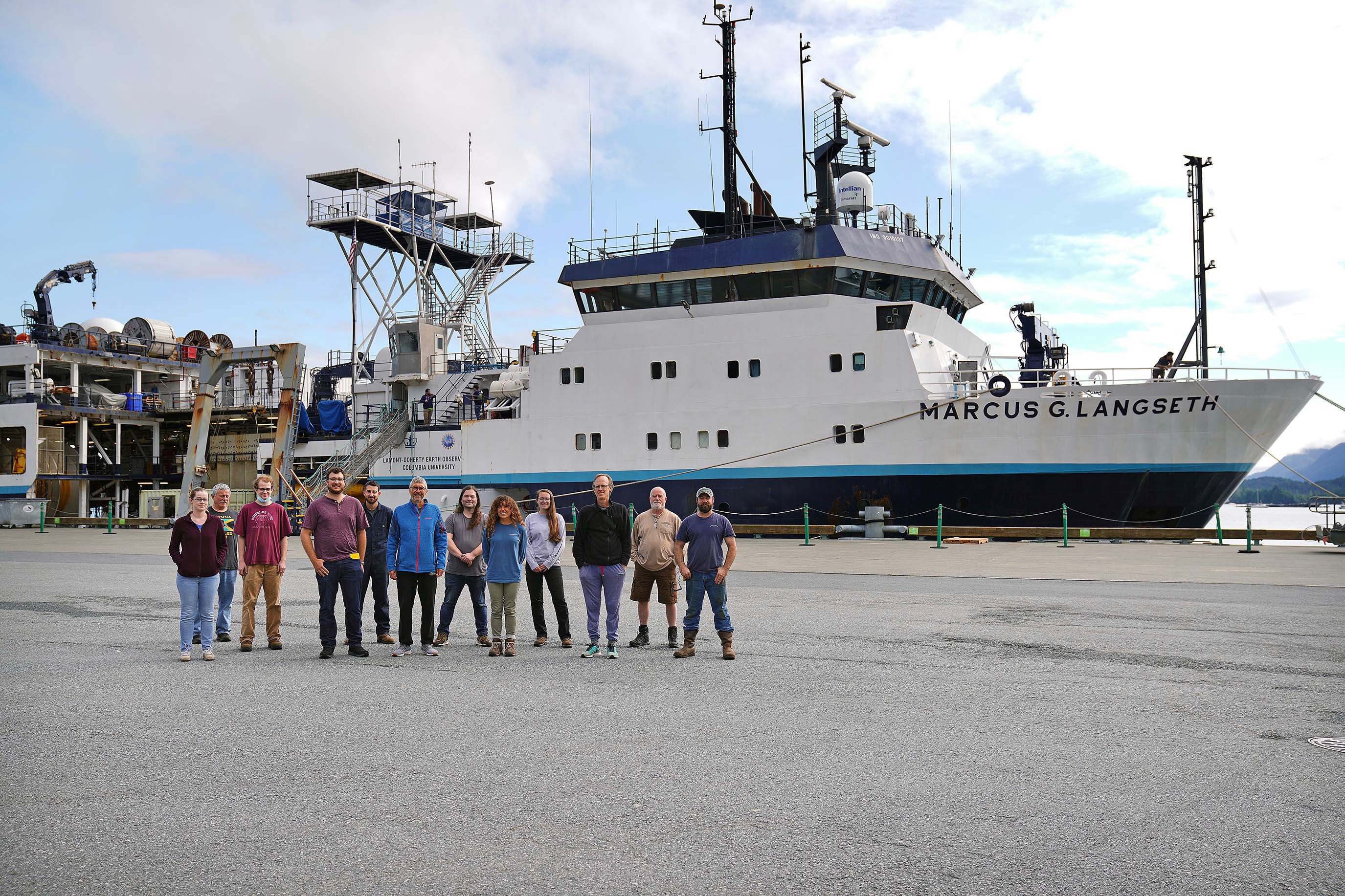
Science team and technical team in front of the Marcus G. Langseth. Pictured: Andrew Barclay, Pete Liljegren, Hannah Brewer, Chris Carchedi, Geena Littel (UBC EOAS), Katie Bosman, Charlie Kleindins, Josh Kassinger, Todd Jensvol, Michael Bostock (UBC EOAS), and Mladen Nedimovic (Dalhousie University). A team of ocean bottom sensor technicians are also on board. Credit: Dustin Safranek