News
Stay up-to-date with what's happening in EOAS

EOAS Climate Myth Busters
We are excited to announce that our newest video series, Climate Myth Busters, is live now! This series showcases brief, 1-minute videos featuring EOAS graduate students and faculty debunking widespread misconceptions about Earth's climate. We are excited to share this content with the public, sparking meaningful conversations around climate science. Watch the videos on Youtube or on our Climate Crisis page.
Climate myth busted #1: Climate change is real but its too late to do anything about it
Xueya Lu, Ph.D. student
Climate myth busted #2: Climate models are unreliable and predicting future climate is impossible
Eva Gnegy, Ph.D. student
Climate myth busted #3: There is no difference between weather and climate
Dr. Rachel White, Assistant Professor
Climate myth busted #4: Climate changes of the likes we are experiencing is part of a natural cycle
Ruth Moore, Master's student

Dr. Catherine Johnson has been elected to the National Academy of Sciences
Dr. Catherine Johnson, Professor in the Department of Earth, Ocean and Atmospheric Sciences, has been elected to the National Academy of Sciences. Dr, Johnson is among 120 new members and 23 international members elected this week, and she joins five other UBC Science researchers as a member of the Academy. The National Academy of Sciences is a private, non-profit institution that was established under a congressional charter signed by President Abraham Lincoln in 1863. It recognizes achievement in science by election to membership, and—with the National Academy of Engineering and the National Academy of Medicine—provides science, engineering, and health policy advice to the federal government and other organizations. Members are elected to the NAS in recognition of their distinguished and continuing achievements in original research. Membership is a widely accepted mark of excellence in science and is considered one of the highest honors that a scientist can receive.
Dr. Johnson uses observatory and satellite data to probe the interior structure and history of terrestrial planets, moons and small bodies in our solar system. She has been a co-investigator on several NASA planetary missions. Recent work by Dr. Johnson has delved into the geological characteristics of Mars and Earth’s moon. The research indicates Mars had a global magnetic field much earlier—and much later—in the planet's history than scientists have previously known. Her work with researchers at the Smithsonian using Apollo mission seismic data shows that some shallow moonquakes can be linked to young faults—evidence that the moon, like Earth, is tectonically active.
Read more:
Five UBC Science researchers join Royal Society of Canada
UBC Science: UBC planetary scientist elected to U.S. National Academy of Sciences
National Academy of Sciences Elects Members and International Members
Dr. Catherine Johnson elected as a member of the American Academy of Arts & Sciences
Professor Catherine Johnson Awarded Killam Research Prize
Call for Logo Designs 2023
The Department of Earth, Ocean and Atmospheric Sciences (EOAS) at the University of British Columbia (UBC) is excited to announce a call for submissions to a Logo Design competition. We are looking for a creative and striking logo that reflects the values of our department, and showcases our commitment to advancing research, education and public engagement in the domain of Earth, Ocean and Atmospheric Sciences.
EOAS is the largest and most diverse department of its kind in Canada, and is recognized as a global leader in Earth Ocean and Atmospheric Sciences. Over the past quarter century, we have worked to realize a vision of interdisciplinary collaboration, tackling complex Earth Sciences research questions. Moving forward, we will continue to implement this vision through high-impact research and teaching, and through public engagement and outreach. We aim to advance our scientific understanding of the Earth System and use this information to guide societal actions towards improved stewardship of Earth’s resources.
The winner of the competition will receive a $500 cash prize and have the opportunity to collaborate with UBC EOAS to refine the logo further.
Eligibility
Participants should be undergraduate or graduate students at UBC or a university program in graphic design, digital media or equivalent.
Requirements and Criteria
-
We are mainly looking for a monochrome logo, but also open to duo-coloured options. In the case where color is used, the logo should include the primary color of UBC EOAS (#096261), and may also optionally use the secondary colors (#E2EBEB and #1B1C1E) Dimensions of the logo should be 400 pixels x 400 pixels (minimum 72 DPI).
-
The logo should be useful for print, website, and social media applications.
-
The logo should reflect the multidisciplinary nature of EOAS, communicate our dedication to Earth, Ocean and Atmospheric Sciences, and reflect the interactions between different elements of the Earth System.
Submission and Selection
-
Please submit the logo in high-quality image format to: comms@eoas.ubc.ca with the email subject line: “EOAS Logo Submission - YOUR NAME - YOUR FIELD OF STUDY - YOUR SCHOOL”.
-
Please feel free to write an art statement or explanation for your logo submission.
-
A committee of faculty, staff, and students representing EOAS will serve as the selection committee.
Deadline for Submissions
June 15, 2023
Terms & Conditions
-
Upon selection, the winning participant agrees to transfer all ownership and intellectual property rights of their submitted logo design to UBC EOAS. This transfer enables the organization to freely use and modify the logo without further permission or compensation.
-
UBC EOAS reserves the right to modify the winning logo and may collaborate with the winning participant for further refinements as deemed necessary.
-
Participants confirm that their submissions are original and do not infringe upon any intellectual property or other rights of any third party.
-
Participants acknowledge that UBC EOAS may utilize the winning design for promotional purposes, including but not limited to, featuring the design on its website, social media accounts, and promotional materials.
-
The winning submission is not guaranteed to be officially adopted by UBC EOAS. UBC EOAS reserves the right to choose an alternative design or refrain from using any submitted designs.
-
By submitting a logo design, participants agree to comply with these rules and any additional terms and conditions imposed by UBC EOAS.
Contact
For more information, please contact comms@eoas.ubc.ca.
More about UBC EOAS:
Website: https://www.eoas.ubc.ca/
Facebook: https://www.facebook.com/ubceoas/
Instagram: https://www.instagram.com/ubceoas/
YouTube: https://www.youtube.com/@ubceoas
Twitter: https://twitter.com/UBCeoas

Meet Davi De Ferreyro Monticelli - Ph.D. Student in Atmospheric Sciences
Davi holds a Bachelor's and Master’s degree in Environmental Engineering from the Federal University of Espírito Santo (UFES, Brazil), and is also an alumnus of the University of Auckland, New Zealand, where he studied for two semesters through the Sciences Without Borders program. At the University of British Columbia, Davi is a Ph.D. Student in Atmospheric Sciences, at the Department of Earth, Ocean, and Atmospheric Sciences (EOAS), supervised by Dr. Naomi Zimmerman. He received the President’s Academic Excellence Award, the W.H. Mathew scholarship, and the 4 Year Doctoral Fellowship. His work aims to investigate the air quality impacts of the emerging cannabis industry and explore the links between odours, air quality, and health.
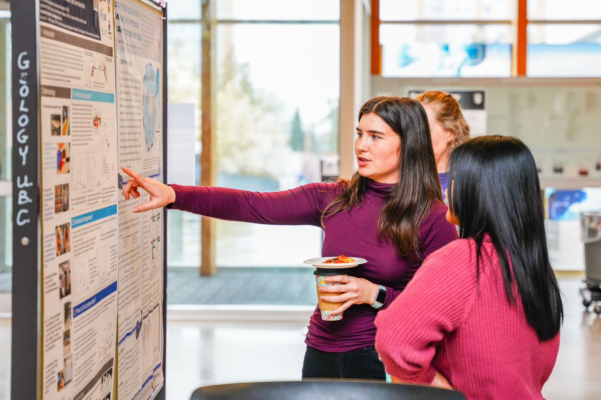
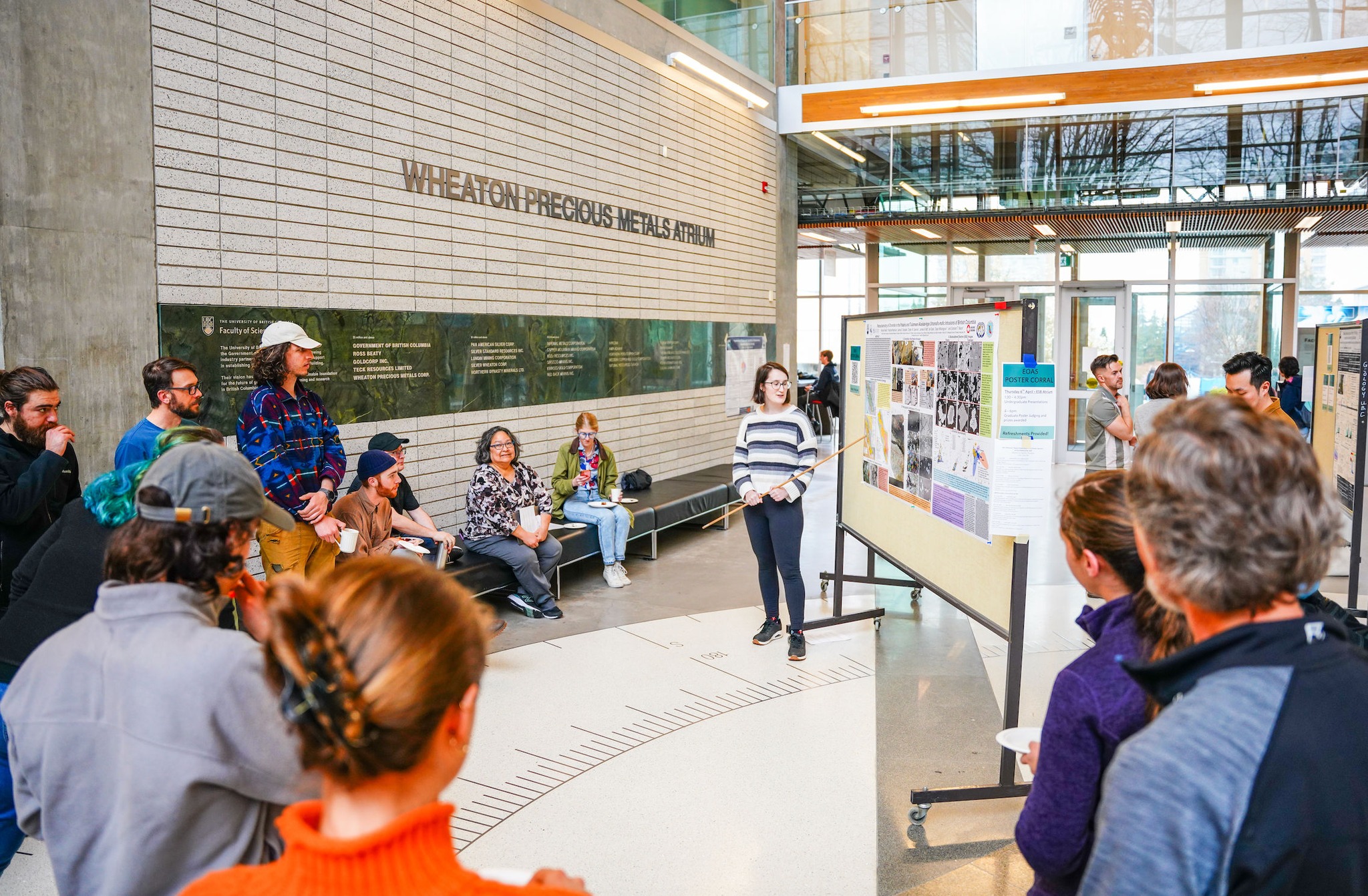
2023 EOAS poster corral
The 2023 EOAS Department Poster Corral took place on April 5th and 6th and a number of graduate and undergraduate posters were displayed in the atrium of the Earth Sciences Building. This has been the first in-person poster corral since 2019, and a wide diversity of work going on across EOAS was shown.
Congrats to the winners!
1st Place: Jasmine Chase
2nd Place: Dr. Colin Rowell
3rd Place: Alexis Bahl
Public-vote undergraduate poster: Rachel Webb
Public-vote graduate poster: Eva Gnegy
Jasmine Chase

Dr. Colin Rowell

Alexis Bahl
Rachel Webb
Study re-evaluates hazards and climate impacts of massive underwater volcanic eruptions
Material left on the seafloor by bronze-age underwater volcanic eruptions is helping researchers better understand the size, hazards and climate impact of their parent eruptions, according to new research from the University of British Columbia.
Roughly 3,600 years ago, the eruption of a semi-submerged volcano in the southern Aegean Sea devastated the island of Santorini, injecting ash, rocks and gas into the atmosphere and depositing kilometres of sediment in terraces on the seafloor.
The catastrophic eruption, and others like it, have traditionally been associated with abrupt climate shifts. But the minor climate impacts of more recent underwater volcanic eruptions, like that of Hunga Tonga-Hunga Ha’apai in 2022, have put that theory in doubt.
Now a multi-year study of ancient Santorini volcano deposits is unravelling the nature of these massive caldera-forming eruptions, and providing new clues as to how future eruptions might impact Earth’s climate.
During massive eruptions, volcanic eruption columns pass through shallow seas as jets of ash, rocks and gases that rise tens of kilometres into the atmosphere. But exactly how, and how much, of that material is then delivered to the sea surface or ground has remained unclear.
“We’ve proved the architecture of volcanic deposits in subaerial and submarine settings can be used to quantitatively constrain the dynamics of the eruption that occurred there, including the vent source and environmental conditions,” said University of British Columbia (UBC) researcher Dr. Johan Gilchrist, lead author the study published in Nature Geoscience (scroll down to watch our interview with Dr. Gilchrist).
“The study also provides crucial lower bounds on eruption strength, jet heights and frequencies and sizes of the sedimentation waves linked to terraced deposits. That will help us predict the evolution of hazards during these caldera-forming eruptions and understand the surprisingly small climate impact of similar events.”
With UBC Earth and planetary scientist Dr. Mark Jellinek, Dr. Gilchrist analyzed the concentric terraces that remain around the Santorini caldera—historically called the Minoan eruption. They discovered that the terrace widths decrease with increasing distance from the vent, and slope backwards up towards the caldera wall, consistent with other terraced caldera deposits. The terraces near the caldera wall are also much broader than those found in caldera from purely submarine or subaerial eruptions.
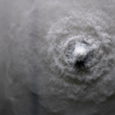
Dr. Gilchrist had a hunch that sedimentation waves collapsing periodically around the volcanic jet spread where they impacted the water surface during shallow submarine eruptions.
To verify the hypothesis, the researchers injected particles into shallow water layers to mimic the submarine Minoan eruption. The experiments proved the descending sedimentation waves caused by shallow water eruptions can impact and spread at the sea surface to create tsunamis and also scour the seafloor, depending on the eruption strength and water depth.
The terraced deposits left a fingerprint outlining what happened during the eruption, the size of the sedimentation waves, and how they interacted with the water and seafloor.
“The limits this study has uncovered will guide a next generation of hydrovolcanic climate models aimed at understanding how the mass partitioning properties of eruptions like Hunga Tonga-Hunga Ha’apai—as well as the largest and most impressive volcanic phenomena in the geological record—minimize their effects on climate change,” said Dr. Jellinek.
Added Dr. Gert Lube, a volcanologist with Massey University not involved in the study: "For the case of three submarine caldera-forming eruptions, this study provides the first direct relationships between the deposit architecture and parental eruption conditions. The results of this study are intriguing and could possibly be extended to non-marine, caldera-forming and smaller eruption events.”
Read the paper here: Submarine terraced deposits linked to periodic collapse of caldera-forming eruption columns
Watch our interview with Dr. Johan Gilchrist: