News
Stay up-to-date with what's happening in EOAS
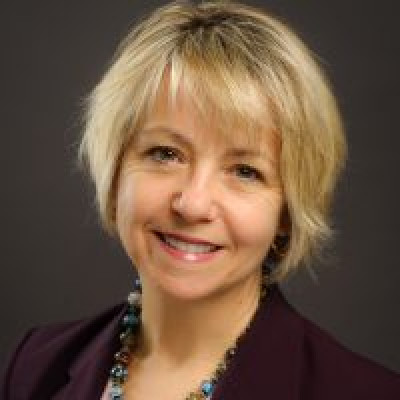
On Earth with Dr. Bonnie Henry - Public Health Officer
Dr. Bonnie Henry was appointed as British Columbia’s Provincial Health Officer in 2018 following three years as the Deputy Provincial Health Officer. As BC’s most senior public health official, Dr. Henry is responsible for monitoring the health of all British Colombians and undertaking measures for disease prevention and control and health protection. Most recently Dr. Henry has led the province’s response on the COVID-19 pandemic and drug overdose emergency. Dr. Henry’s experience in public health, preventive medicine and global pandemics has extended throughout her career. She served in a number of senior roles at the BC Centre for Disease Control and Toronto Public Health, including as the operational lead in the response to the SARS outbreak in Toronto. She has worked internationally with the WHO/UNICEF polio eradication program in Pakistan and with the WHO to control the Ebola outbreak in Uganda and has been actively involved in mass gathering health planning in Canada and internationally. She is a specialist in public health and preventive medicine and is board certified in preventive medicine in the U.S. She graduated from Dalhousie Medical School, completed a Masters in Public Health and residency training in preventive medicine at University of California, San Diego and in community medicine at University of Toronto. She is an associate professor in the School of Population and Public Health at the University of British Columbia.
Heatwave paper co-authored by EOAS scientists made the N.Y. Times front page
Dr. Roland Stull, Dr. Rosie Howard, and Mr. Christopher Rodell from the Department of Earth, Ocean & Atmospheric Sciences are among the many co-authors on a World Weather Attribution (WWA) paper that made the front page of The New York Times on July 8, 2021. The complete N.Y. Times article can be found here.
According to the team of leading climate researchers, the extreme heatwave that happened very recently in parts of the US and Canada would have been “virtually impossible" without the influence of human-caused climate change, which made the heatwave at least 150 times more likely to happen.
Although the record-breaking temperature observations made it difficult to quantify how rare the heatwave is, the researchers concluded that the event would have been virtually impossible without human influence. The heatwave was about 2°C hotter than it would have been if it had occurred at the beginning of the industrial revolution when global mean temperatures were 1.2°C cooler than today. Looking into the future, an event like this would occur a lot less rare – almost every 5 to 10 years, if we continue living in a world with 2°C of global warming, which could be reached as early as the 2040s at current emission levels.
The researchers found two alternative explanations for how climate change made the extraordinary heat more likely. The first is that the event remains a very unusual event, albeit the aggravation of climate change. The other possible explanation is that nonlinear interactions in the climate have substantially increased the probability of such extreme heat, much beyond the gradual increase in heat extremes that has been observed up to now. This is a possibility that needs to be explored in future studies.
The study provides a strong warning that the rapidly warming climate is leading us into an unknown world that has significant impacts on our life, and that adaptation plans should be designed to prepare societies for a very different future.
The heatwave paper has been cited in over 3,300 news media articles around the world till July 12. A list of the media articles with links can be found here.
See below for the WWA article and the full study.
World Weather Attribution article: Western North American extreme heat virtually impossible without human-caused climate change
Full study, PDF version: Rapid attribution analysis of the extraordinary heatwave on the Pacific Coast of the US and Canada June 2021
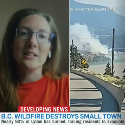
Dr. Rachel White Interviewed on BC's Heat Dome
Dr. Rachel White, an assistant professor in the Department of Earth, Ocean & Atmospheric Sciences, researches climate change and atmospheric dynamics. A major focus of her work is studying how large-scale atmospheric dynamics contribute to extreme weather events such as heat waves and cold snaps.
Her expertise has made her a valuable contact for global news outlets reporting on the recent record-breaking temperatures in British Columbia over the last week. Times Radio in the UK interviewed her on the mechanics of the heat dome and its connection to climate change (interview starts at minute 8:30). The CBC published an interview on understanding the dangers high wet-bulb temperatures pose to human health, and The Globe and Mail on increasing baseline temperatures resulting in unusually hot nighttime temperatures. Catch Dr. White’s live interview on CTV News on the wildfires spreading through BC after the unprecedented heat wave. Check this page for updates as more of her interviews are published.

Happy Pride Month!
To Celebrate Pride Month, we’d like to draw your attention to some of our talented colleagues who identify as part of the LGBTQ2SIA+ Community. Hopefully their stories will help young queer people feel comfortable exploring a future in science. The Pacific Museum of Earth team designed this beautiful geo-Pride Flag using images of rocks and minerals in the museum's collection. Can you name all of the specimens that make up the flag? (answer key is at the bottom of this page)
Professor Kendra Chritz – Geochemist & Paleoecologist
Kendra Chritz is an assistant professor in the Department of Earth, Ocean & Atmospheric Sciences. She looks at the chemistry of ancient biological material (teeth, bones, soils) to tell what past environments were like. Her particular interest is in the intersecting interactions between people and their ecosystems over time: how the environments we evolved in made us who we are, how prone we are to modifying our environments, what we’re doing to environments now. Because of her particular focus on the ancient evolutionary aspect of her work, I do most of my research in museums around the world and in the field in eastern Africa, where we evolved.
Professor Sara Harris – Climate Science Educator
Sara Harris is a Professor of Teaching in the Department of Earth, Ocean and Atmospheric Sciences at the University of British Columbia. She typically teaches climate science, environmental science, and oceanography, which she will continue after she finishes serving in the Faculty of Science Dean's Office as Associate Dean Academic.
Anthony Di Stefano – Atmospheric Scientist
Anthony Di Stefano is a PhD student in the Department of Earth, Ocean & Atmospheric Sciences at the University of British Columbia. Anthony is an atmospheric scientist whose work aims to improve the representation of clouds and precipitation in weather forecast models. His goal is to produce higher-accuracy precipitation forecasts in British Columbia. In the new normal brought on by the COVID-19 pandemic, Anthony is taking time to re-examine his purpose, in research as in everyday life. His aim is to bring social and scientific views of the weather closer together, and to be part of a science community embracing greater standards of inclusion, equity and justice.
Daniel Gowryluk – Museum Educator
Daniel Gowryluk is the Education Outreach Coordinator and Assistant Curator at the Pacific Museum of Earth. Daniel joined the PME team in 2018 following a successful career path through several other science museums—from Manitoba to British Columbia. He has a passion for inspiring curiosity and wonder in all museum visitors and has fundamentally reshaped the museum’s outreach voice through his whimsical and upbeat personality.
Professor Mitch D’Arcy – Geomorphologist
Mitch D’Arcy is an Assistant Professor in the Department of Earth, Ocean & Atmospheric Sciences at the University of British Columbia. Mitch joined the faculty at UBC in March 2020, making him one of the newest faculty members. He is a geomorphologist who studies how climate change influences surface processes on Earth. Originally from London in the U.K., Mitch has been in Germany for the past years prior to his move to Vancouver.
Professor Stuart Sutherland – Micro-Palaeontologist
Stuart Sutherland is a micro-paleontologist and Professor of teaching in the Department of Earth, Ocean & Atmospheric Sciences at the University of British Columbia. Originally from the U.K., Stuart has been in Vancouver since 2000 when he joined the faculty at UBC. He is an award-winning educator and currently serves as the Chairperson of the Pacific Museum of Earth’s Governing Committee.
Geo-Pride Flag answer key:
Bars:
- Red = Zoisite/ Thulite from Canada
- Orange = Opalized wood from Nevada
- Yellow = Sulfur from San Felipe, Baja California, Mexico
- Green = Uvarovite from Russia
- Blue = Lapis from Afghanistan
- Purple = Amethyst from Brazil
Chevrons:
- Black = Hemtatite from Cumberland, UK
- Brown = Crocidolite from South Africa
- Pink = Rhodocrosite, No Location Data
- Blue = Halite/Salt from Saskatchewan
- White = Opal from Coober Pedy, South Australia
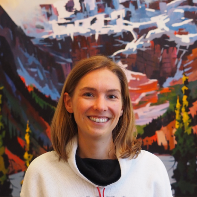
On Earth with Dr. Lindsey Heagy
Lindsey Heagy is joining EOAS as an Assistant Professor this July. She completed her BSc in geophysics at the University of Alberta in 2012 and her PhD at UBC in 2018, where she was a Vanier Scholar. Following the completion of her PhD, she was a Postdoctoral researcher in the Statistics Department at UC Berkeley. Her research interests are in data science and inverse theory, and she is interested in applications including minerals, groundwater, and environmental studies. She is a co-founder and project-lead for SimPEG, an open-source software project for geophysical inversions that has been adopted by geoscientists internationally at multiple universities, national labs, and mining companies. In 2019, she was awarded the Gerald W. Hohmann Outstanding Young Scientist award for advances in simulation and inversion of electromagnetic data and promotion of an open source culture for collaborative, inclusive and reproducible research.
On Earth with Dr. Kendra Chritz
Dr. Kendra Chritz looks at the chemistry of ancient biological material (teeth, bones, soils) to tell what past environments were like. Her particular interest is in the intersecting interactions between people and their ecosystems over time: how the environments we evolved in made us who we are, how prone we are to modifying our environments, what we’re doing to environments now. Because of her particular focus on the ancient evolutionary aspect of her work, I do most of my research in museums around the world and in the field in eastern Africa, where we evolved.