Tools for Landslide Risk Management Decisions

Alex Strouth and Scott McDougall
Quantitative risk assessments are used in BC to estimate life-loss risk at landslide hazard sites, and to compare these estimates with risk tolerance thresholds to determine the necessity for, and extent of, protection measures. The risk estimates are often calibrated by so-called ‘expert judgement’ because historical landslide fatality data are not readily available, and risk tolerance thresholds are referenced without a clear understanding of their origin or limitations. Our recent publications illuminate these issues, providing historical context, data, and suggestions for risk managers who make decisions about landslides that threaten human life. “Historical Landslide Fatalities in British Columbia, Canada” provides data in a format that can be used to calibrate quantitative risk estimates. It shows that landslides cause an average of one fatality per year in British Columbia and summarizes the historical frequency of multiple-fatality events (Figure 1). “Societal risk evaluation for landslides” provides a history of, and suggestions for, risk evaluation tools (in a format like Figure 1) that are used to determine if a community that faces landslide risk is ‘safe enough’. Our future research seeks a method for using the province-wide historical data to calibrate the site-specific risk evaluation tool.
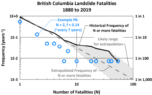
Historical frequency of multiple-fatality landslide events in British Columbia.